
Dunkeld, Bishop's Palace


House (Medieval), Tower House (Medieval)
Site Name Dunkeld, Bishop's Palace
Classification House (Medieval), Tower House (Medieval)
Alternative Name(s) Bishop's Hill; Dunkeld Castle
Canmore ID 27168
Site Number NO04SW 15
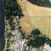
NGR NO 022 426
NGR Description NO c. 022 426
Datum OSGB36 - NGR
Permalink http://canmore.org.uk/site/27168


- Council Perth And Kinross
- Parish Dunkeld And Dowally
- Former Region Tayside
- Former District Perth And Kinross
- Former County Perthshire
NO04SW 15 c. 022 426
(Name centred NO 0235 4252) Bishop's Palace (NR) (Site of)
OS 6" map, Perthshire, 2nd ed. (1901).
Formerly entered at cited location NO 023 427.
Not to be confused with Dunkeld, Bishop's Hill, New Palace (NO 0204 4264), for which see NO04SW 29.
The Bishop's Palace originally consisted of several long thatched houses of two storeys. For greater security a castle was erected close to it in 1408, which comprised a great hall, vaulted granaries, etc. In 1508, a wing was added to the palace and, adjoining to it, a private chapel. Nothing now remains.
New Statistical Account (NSA) 1842
Field Visit (17 April 1975)
The grounds of the Cathedral have been landscaped, and except for a terrace locally believed to have housed a building at NO 0244 4254, and another slight scarp at NO 0233 4253, representing the E and S parts of a large levelled area, there is nothing to indicate the site of the Bishop's Palace nor of the other buildings noted in the NSA.
Visited by OS (AA) 17 April 1975.
Field Visit (April 1989)
There are no visible remains of the Bishop's Palace which is on record in the early 15th century; described as 'a rambling structure in the highland fashion', it is said to have stood to the SW of the Cathedral. Slezer, however, depicts a tower to the W of the Cathedral, probably that built by Bishop Robert de Cardeny (1398-1436) who is also credited with having built 'a hall with larder and granaries underneath'; these may have been within the tower, or could have been separate. Bishop George Brown (1483-1514) added a wing on the W and an oratory.
Visited by RCAHMS (IMS) April 1989.
J Slezer 1693; Dunkeld Rentale 1915.
Note (2008)
These notes were prepared from an examination of post-reformation feus mainly of prebendial mansions in Dunkeld from the printed SRO volumes of the Register of the Great Seal covering 1580-1633, and other sources including on-line. The research was carried out in Northampton using sources to hand, and as with 'Notes on the Medieval town of Scone' produced 20th May last year, demonstrates the need for more thorough documentary research on key medieval towns in Scotland.
The research provided the following insight into the town or city of Dunkeld:
1. That the medieval town lay west and east of the Cathedral, along much the axis of the present Cathedral Street, with the Cathedral standing about the centre of the town, as suggested in the New Statistical Account (p960). After being destroyed by fire in 1689 Dunkeld was rebuilt east of the Cathedral only, and the houses and gardens to the west and north-west of the Cathedral, occupying about five acres, was never rebuilt and became part of the Duke of Atholl's park (Old Statistical Account p413; NSA p960, 962).
2. That part of the medieval town lay south of the River Tay at Little Dunkeld, known in some documents as the Burgh of Little Dunkeld.
3. That the Bishop's Palace may have been south-west of the Cathedral as suggested in the New Statistical Account p972-3. Also one document refers to 'lie muthill' here, which might signify a motte.
4. That the original site of St George's Hospital may have been west of the Cathedral prior to 1689, even if it was rebuilt subsequently in 1757 to the east, where Ell House stands.
5. That the mansion house of the Duke of Atholl prior to 1653 may have been east of the Cathedral.
T C Welsh 2008.
Geophysical Survey (13 November 2019 - 27 February 2020)
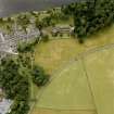
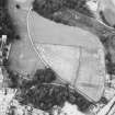
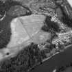
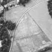
NO 02250 42750 Large-scale geophysical survey and targeted excavations surrounding Dunkeld cathedral. The survey was undertaken between 13 November 2019 and 27 February 2020 in order to identify any potential vallum or enclosing elements that may have been associated with the early use of the ecclesiastical site. Sample excavation outside of the scheduled area over what was interpreted as a possible vallum was then undertaken. This forms part of a wider project investigating the development of early medieval kingdoms in Northern Britain and Ireland (The Comparative Kingship project).
The potential early medieval features include a possible vallum which curves in a roughly east-west arc that seems to be truncated by later features associated with medieval burgh, as well as possible burial monuments, though the latter are a tentative. The majority of both of these features lie outside the scheduled area. Excavation is needed to clarify the dates and function of these features. Other features such as enclosures and field boundaries may be or equally important and early in date,
though these are more difficult to assess thorough geophysical survey alone.
The most spectacular result of the survey was the identification of the western extent of the medieval burgh surrounding the cathedral of Dunkeld. This revealed, in great detail, the layout of individual houses, streets and avenues within the town, but also ancillary features such as roads approaching the town from the north and west. All this is located in areas that by Roy’s mapping was simply gardens/fields. Additionally, the results also reveal an extensive structure to the west of the surveyed area, linked with the town by a wide road or trackway. While we have suggested this may be one of either a country house partially built by the Duke of Atholl in 1830 or the Bishops Palace, excavation is needed to clarify these extensive and complex remains.
Information From James O'Driscoll and Gordon Noble (University of Aberdeen)
OASIS ID: jamesodr1-407623

