
Pricing Change
New pricing for orders of material from this site will come into place shortly. Charges for supply of digital images, digitisation on demand, prints and licensing will be altered.
Lewis, Cunndal


Lazy Beds (Post Medieval)
Site Name Lewis, Cunndal
Classification Lazy Beds (Post Medieval)
Alternative Name(s) Butt Of Lewis
Canmore ID 270561
Site Number NB56NW 29
NGR NB 5150 6560
NGR Description Centred on NB 5150 6560
Datum OSGB36 - NGR
Permalink http://canmore.org.uk/site/270561


- Council Western Isles
- Parish Barvas
- Former Region Western Isles Islands Area
- Former District Western Isles
- Former County Ross And Cromarty
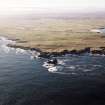
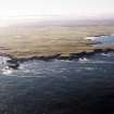
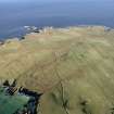
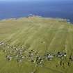
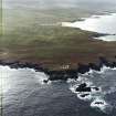
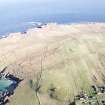
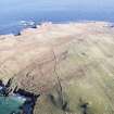
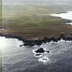
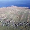
NB56NW 29 centred on 5150 6560
A large expanse of lazy bed cultivation with different alignments stretches from the Butt of Lewis lighthouse (NB56NW 8) to Cunndal. It is overlain by the linear fields of the improved crofts at Eoropie to the E and is probably a continuation of the field-system depicted on the 1st edition of the OS 6-inch map (Island of Lewis, Ross-shire 1853, sheet 1) to the SW (NB56NW 19). Considered together with the cultivation remains visible on the NE coast (NB56NW 28), this expanse represents a very large area of cultivation subsequently abandoned.
Information from RCAHMS (SMDG) 1 February 2005

