
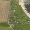
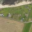
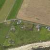
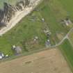
South Ronaldsay, Cara Battery


Gun Emplacement(S) (20th Century)
Site Name South Ronaldsay, Cara Battery
Classification Gun Emplacement(S) (20th Century)
Canmore ID 270379
Site Number ND49SE 28.02
NGR ND 48003 94657
NGR Description ND 48003 94657 and ND 48019 94645
Datum OSGB36 - NGR
Permalink http://canmore.org.uk/site/270379


- Council Orkney Islands
- Parish South Ronaldsay
- Former Region Orkney Islands Area
- Former District Orkney
- Former County Orkney
ND49SE 28.02 48003 94657 and 48019 94645
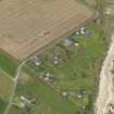
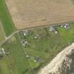
Two shuttered concrete gun-emplacements with rear blast walls. There are very short canopies in both. Entrance is through the rear and sunken concrete pathways lead from the rest of the site.
The holdfast with bolts set into the concrete floorsurvives in both emplacements and a metal plate/ring with graduated scale up to 230 degrees surrounds this fitting.
Built to mount 12-pounder guns.
Visited by RCAHMS (DE, GS), May 1997

