
Pricing Change
New pricing for orders of material from this site will come into place shortly. Charges for supply of digital images, digitisation on demand, prints and licensing will be altered.
Bertha


Roman Fort (Roman)
Site Name Bertha
Classification Roman Fort (Roman)
Canmore ID 26734
Site Number NO02NE 25
NGR NO 0974 2680
NGR Description Centred NO 0974 2680
Datum OSGB36 - NGR
Permalink http://canmore.org.uk/site/26734


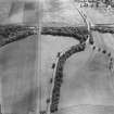
![Photograph of an extract of OS map (NO0826 & NO0926) annotated with measurements.
[This is a close-up section of C59680.]](http://i.rcahms.gov.uk/canmore/l/SC01951306.jpg)


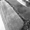


![Photograph of an extract of OS map (NO0826 & NO0926) annotated with measurements.
[This is a close-up section of C59680.]](http://i.rcahms.gov.uk/canmore/s/SC01951306.jpg)


- Council Perth And Kinross
- Parish Redgorton
- Former Region Tayside
- Former District Perth And Kinross
- Former County Perthshire
NO02NE 25 centred 0974 2680
For suggested Roman bridge over the River Tay (at NO 0993 2698), see NO02NE 22.
(NO 0974 2680) Bertha (NAT) Roman Fort (R).
OS 6" map (1959)
A Roman fort here was recognised by Maitland before 1757. He identified north and south ramparts, the latter on the north bank of the Almond, and also refers to an arable mound called the Causewayridge skirting the former and representing a 'Military Way'.
Roy plans the fort astride the Almond, apparently using Maitland's south rampart as his north one, and blaming the river for washing away the remains on the south side.
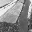
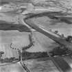
Callander examined the ground in 1917 and produced a plan which seems to have been accepted ever since. He had no doubt about the south rampart (breadth c.20' and up to 6' high), and was also satisfied with traces of the western rampart (a ridge 20 yards broad and 1' high) and the northern rampart (another ridge 30 yards broad and up to 4' high, but note that Maitland refers to a ridge as well as a rampart here), and with the NW and NE angles (described rather vaguely). He concludes by saying that there are so few structural remains that no definite conclusions can be come to regarding the greater part of its boundaries. Crawford, after air (visible on F21.58/RAF/1773: 0017) and ground investigation, also produced a plan, similar to Callendar's, and identifies particularly the NW and SW sides. St Joseph notes that the narrow south rampart is quite different from the massive remains of the northern one, and that 'if it is Roman at all', it may be a late feature reducing the area of the fort, possibly after erosion.
No finds are recorded from within the fort area, but several, now lost, are said to have come from an area between it and Almond Bridge - pillars, urns (one containing a glass phial), a possible amphora, a pig of lead etc (J Cant 1774): some glass vessels from somewhere in the area were presented to SAS 1781, and a 2nd c. inscribed stone 'Discipulinae Augusti' was found c.1958 'close to the site of the Roman Camp of Bertha' (M E C Stewart 1958).
The name'Bertha'is a 14th C invention by John of Fordoun, but a 'Rath inver Amon' (fort at the mouth of the Almond) is recorded in the Dark Ages (O G S Crawford 1949). Richmond identifies the site with Ptolemy's 'Tamia' (I A Richmond 1922).
J G Callander 1919; W Maitland 1757; W Roy 1745; J K St Joseph 1958
The NW and SW sides of the fort remain visible as broad mounds in cultivated fields, but there is no trace of the NE side except for a suggestion of its commencement at the N corner of the fort. Two offset ramparts of earth in a wood on the edge of the river bank may represent remnants of the S. side, but they are un-Roman-like in appearance and may be later features.
Surveyed at 1/2500.
Visited by OS (JTT) 11 November 1965
The slab mentioned by Stewart was found in the river-bed near the S bank of the river Almond, opposite the fort. St Joseph suggests that there seems to have been more than one period of occupation of this fort.
R P Wright 1959; J K St Joseph 1965
The alignments of the SW and NW ramparts of the fort are still marked by the broad ridge described by Callander and the approximate centre can be readily ascertained at point A and B (see plan). The alignment of the NW side is clear E of the railway, and a similar but narrower ridge, not mentioned by Callander, running clear of the hedge, almost certainly represents the alignment of the NE rampart. The crop mark of the two ditches shown on St Joseph's AP (AKC 73) when plotted fall either side of the ridge marking the SW rampart. The gap noted by Callander 55 yds from the N end is no longer evident and does not show on the APs. Two sections (at approximately C and D) cut in October 1973 confirmed the alignment of a Roman ditch. A section of another ditch outwith the fort and apparently running roughly E-W, has in the course of the past weeks been exposed at 'E'. Further imminent construction work excavations are expected to uncover more of this enigmatic ditch.
Revised at 1:2500.
Visited by OS (AA) 9 May 1974
Three pot sherds, one mortaria, one orange fabric, one tile, stray finds from Bertha fort have been donated to Perth Museum and Art Gallery (Accession no 1988.90.1-3).
A G Reid 1988.
Material from Bertha Roman fort excavation in 1973, including a fragment of an upper quern-stone, pottery and ironwork, is now in Perth Museum and Art Gallery (Accession no:1989.178).
M D King 1990.
NO 097 268. Analysis of a collection of previously unreported fieldwalking finds collected by the Cumbernauld Historical Society during the 1970s, but never before studied, provided evidence that the fort (as has long been suspected) was occupied in the Antonine period as well as the Flavian.
Sponsor: Roman Gask Project.
D J Woolliscroft 1999
The small archive from the 1973 excavations at Bertha have been catalogued. It consists of photographic material, manuscripts and drawings.
Historic Scotland Archive Project (FO) 1996
Project (2008)
NO 097 268 Resistance and magnetic surveys were conducted on the surviving parts of the fort itself, along with an area to its N. The site has never shown well from the air and little excavation has taken place, but the survey revealed a series of internal structures with unusual clarity, including barracks, rampart ovens and possible courtyard buildings as well as the defences and internal road network. In the W, two ditches were found running across the fort interior. These may suggest that the site was cut down (or extended) at some point, or that what had been thought to be the western end of the fort is actually an annexe. Outside the fort, a
considerable area of rig and furrow cultivation was visible along with a ditch running parallel to the fort’s northern defences, but c80m from them.
Archive: 55 Broadwalk, Pownall Park, Wilmslow, Cheshire, SK9 5PL
Funder: The Roman Research Trust
DJ Woolliscroft and B Hoffmann (The Roman Gask Project), 2008
Earth Resistance Survey (2008)
NO 097 268 Resistance surveys.
Archive: 55 Broadwalk, Pownall Park, Wilmslow, Cheshire, SK9 5PL
Funder: The Roman Research Trust
DJ Woolliscroft and B Hoffmann (The Roman Gask Project), 2008
Magnetometry (2008)
NO 097 268 Magnetic surveys.
Archive: 55 Broadwalk, Pownall Park, Wilmslow, Cheshire, SK9 5PL
Funder: The Roman Research Trust
DJ Woolliscroft and B Hoffmann (The Roman Gask Project), 2008
Aerial Photographic Transcription (22 November 2019)
An interpretative transcription, or mapping, of information on oblique aerial photographs was produced on 22 November 2019.
Metal Detector Find
NO 0987 2690 Illegal metal detecting within the scheduled area of Bertha Roman fort recovered mostly non-descript, modern detritus along with a Romano-British copper alloy brooch and a 19th-century dress fitting. The brooch is an enamelled umbonate disc brooch with a catch-pin fastening. It measures 40 x 39.4mm; max thickness 17.4mm; and weighs 19.12g (with some adhering soil, including charcoal flecks). It is comparable, though not identical to a disc brooch from Newstead. It presumably falls within a 2nd 3rd-century date bracket. Although the majority of the blue and red chevron enamel cells are intact the central, round cell, is empty and the brooch is generally abraded, with damage to the projections and the pin (the tip of which is missing).
The enamelled copper alloy dress fitting is in a style, colouring and condition which suggest a medieval inspired, 19th-century date. It measures 18.2mm in diameter, with a closed length of 16.1mm and a fully open length of 47.9mm. It weighs 5.33g. On one side is a crescent moon and star (the moon infilled with scrolls against white enamel; the star surrounded by pellets against a blue enamel ground). The other side shows a bird that looks rather like a flamingo, but may be intended as a pelican in her piety image. Two pairs of closing rings are hinged by small floral studs. Two further single rings may have lost their matching opposites.
Claimed as Treasure Trove (TT 85/10), allocated to Perth Museum and Art Gallery, with no finder reward being paid
Perth Museum and Art Gallery/ National Museums Scotland

