
Pricing Change
New pricing for orders of material from this site will come into place shortly. Charges for supply of digital images, digitisation on demand, prints and licensing will be altered.
Ardargie


Moated Site (Medieval)
Site Name Ardargie
Classification Moated Site (Medieval)
Canmore ID 26671
Site Number NO01SE 2
NGR NO 0827 1437
Datum OSGB36 - NGR
Permalink http://canmore.org.uk/site/26671


- Council Perth And Kinross
- Parish Forgandenny
- Former Region Tayside
- Former District Perth And Kinross
- Former County Perthshire
NO01SE 2 0827 1437.
(NO 0827 1437) Roman Camp (R) Earthwork.
OS 6" map, Perthshire, 2nd ed., (1901); OS 6" map, (1959)
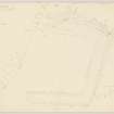
Listed as a Homestead Moat (information from RCAHMS). It is 38ft wide on three sides, enclosing a platform 200ft across. There was originally a bank on both sides of the moat, the outer bank being best preserved on the S.W. side. A steep gully replaces the moat on the east side and there are faint possible traces of an inner bank. There is no entrance gap. The site and visible remains have nothing Roman about them and a Medieval or Dark Age date is more likely (information from RCAHMS).
O G S Crawford 1949.
This homestead moat is as described above.
Resurveyed at 1/2500.
Visited by OS (J T T) 8 November 1965.
This site is listed in an Atlas of Scottish History (McNeill and MacQueen 1996) as a moated site.
Information from RCAHMS (DE) September 1997
Field Visit (15 May 1957)
Earthwork, Ardargie
Although it has masqueraded as a Roman fort from time to time, this rectilinear earthwork is certainly medieval. It occupies the forward edge of a plateau-like summit facing W,, and possesses good natural defence on the S in the form of a steep-sided ravine. The ground o the W falls sharply, but from both the N and E the approach is level.
The earthwork is bounded on the S side by the ravine and on the other 3 sides by a substantial ditch measuring 44 ft in width and 11ft in depth. Although the plan shows traces of both internal and external banks, it is not certain, in the absence of excavation, precisely what they represent. Thus, the slight bank inside the ditch on the W may be nothing more than a ruined field boundary, corresponding to those on the N and E sides, while the broad mound immediately outside the ditch on the W seems to be largely natural, its sharply defined foot being in fact a negative lynchet produced by cultivation of the ground immediately outside the earthwork. The external bank on the N side seems, on the other hand, to be artificial, although it has been cut back by ploughing.
On the W side the ditch presumably ran in to the ravine, the present gap at the S end being of recent origin. On the E, however, the rounded end of the ditch may conceivably indicate the site of the original entrance, although this can hardly have been as wide as the present gap between the ditch terminal and the ravine. The interior of the earthwork is under cultivation, and no internal structures are visible. The formidable nature of the ditch suggests that this earthwork may be an early castle site, similar to St John Graham’s castle in Stirlingshire, rather than a homestead moat.
Visited by RCAHMS 15 May 1957
Field Visit (1996 - 2003)
Russell Coleman managed an Historic Scotland funded project to record medieval moated sites in Scotland. Gazetteers were produced for each regional council area between 1996 and 2002 with an uncompleted overall review in 2002-03. The results of the first year of the project were published in Tayside and Fife Archaeological Journal, Volume 3 (1997).

