
Pricing Change
New pricing for orders of material from this site will come into place shortly. Charges for supply of digital images, digitisation on demand, prints and licensing will be altered.
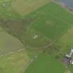
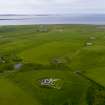
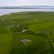
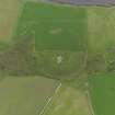
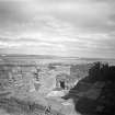
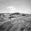
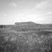
Wyre, Cubbie Roo's Castle


Castle (Medieval)
Site Name Wyre, Cubbie Roo's Castle
Classification Castle (Medieval)
Alternative Name(s) Kolbein Hruga; Cobbie Row's Castle; Castle Of Cobbie Row; Cubbie Row's Castle
Canmore ID 2665
Site Number HY42NW 5
NGR HY 44179 26296
Datum OSGB36 - NGR
Permalink http://canmore.org.uk/site/2665


- Council Orkney Islands
- Parish Rousay And Egilsay
- Former Region Orkney Islands Area
- Former District Orkney
- Former County Orkney
HY42NW 5 44179 26296
(HY 4418 2630) Cubbie Row's Castle (NR)
OS 1:10,000 map, 1977.
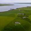
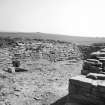
Dating from the Norse occupation, remains of the oldest medieval castle known to exist in Scotland. The Orkneyinga Saga tells how, about 1145, Kolbein Hruga built a fine stone castle (steinkastala) on the island of Wyre. Cobbie Row is a corrupted form of this name, and as examination has failed to yield traces of earlier structures, then the existing remains are the steinkastala (W D Simpson 1954).
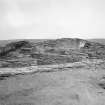
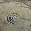
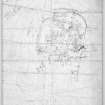
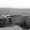
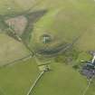
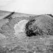
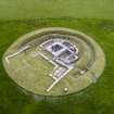
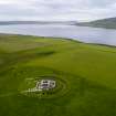
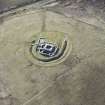
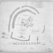
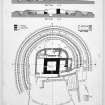
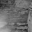
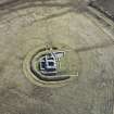
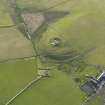
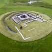
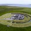
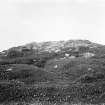
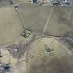
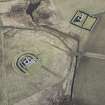
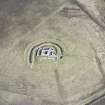
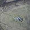
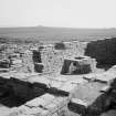
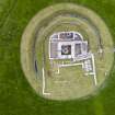
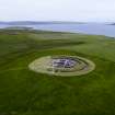
The site, which occupies the summit of a considerable hillock has for its outer defence a crescentic ditch (partly destroyed) some 5 ft 9 ins wide at the bottom and now about 6 ft deep. A low mound crowns the counter- scarp, while the scarp bears the remains of a wall which appears to have originally enclosed an oval area, approximately 95 by 75 ft. At a later date, the wall was demolished in the SW sector and a rectangular extension built outwards (see RCAHMS 1946 plan fig.325). Inside the wall, a second ditch has been excavated through rock, leaving a level central platform, some 48 by 54 ft, on which the principal buildings stand. These buildings can be referred to four main periods
of construction.
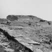
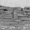
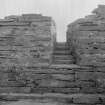
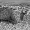
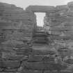
Near the centre of the platform and earliest in date is a small tower, almost square, which stands to a height of about 8 ft. It measures 25 ft 7 ins by 26 ft over walls 5 ft 7 ins thick at base, and its masonry is of undressed flagstones. Dr Marwick points out that the entrance must have been in the missing first floor and what remains is a well-room and storehouse. There is insufficient evidence from which to date this tower. The masonry in no way resembles that of the enclosing wall, which may be considered original. It does not differ greatly in construction from the walling of the chapel (HY42NW 4) but it is better and more substantial. It is unsafe to assume that a personal tower was erected by a layman as early as the middle of the 12th century, especially in the total absence of any evidence. A fragment of chain mail found on the site might belong to any period from the 12th to 15th century.
First Addition: By a subsequent addition to the NE corner, the tower became L-shaped. This addition had at least one upper floor.
Second Addition: This extended from the N side of the tower, and a forestair against the E wall is evidence for an upper storey.
Third Addition: In a subsequent expansion, the W part of the platform was entirely covered by a building enveloping the W side of the tower and its second addition.
Fourth Addition: Against the E walls of both wing and addition, and end-on to the N side of the passage rose another small extension, possibly a soil-chamber.
On the S of the passage and the masonry platform extending from the tower are vestiges of still later buildings, including a hall.
RCAHMS 1946, visited 1935; W D Simpson 1950.
Cubbie Row's Castle (as per DoE [HBM] plaque): As described and planned by the RCAHMS.
Surveyed at 1:2500.
Visited by OS(ISS) 13 October 1972.
'Cubbie Roo's Castle'
Information from Orkney Islands Council and Tourist Board to OS 4 August 1982.
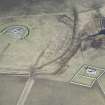
Sites identified as part of a desk-based assessment followed by a broad-scale landscape survey.
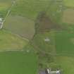
HY 44175 26295 Cubbie Roo's Castle
HY 44159 26293 A sub-rectangular stony mound containing some areas of coursed masonry, although not forming any particular structure measuring approximately 15m by 6m and orientated north south. Possible spoil heap containing archaeological material.
HY 44187 26303 A sub-rectangular building platform on the slope of the mound and just east of the castle. This is orientated north-south and measures approximately 20m by 8m. This site relates to where a hen house once stood in the early 20th century, although this was thought to incorporate the remains of a much earlier structure.
Antonia Thomas 2006.
Field Visit (June 1982)
Cubbie Row's Castl HY 4418 2630 HY42NW 5
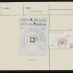
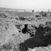
Kolbeinn Hruga was a powerful magnate of the mid-twelfth century who has passed into folk-memory as the giant 'Cubbie Row'. This structure on a rounded hilltop is evidently the 'good stone-castle' which according to Orkneyinga Saga he built in Wyre shortly before 1150 and in which, in Hakonar Saga, the slayers of Earl Paul stood siege in 1231. The latter source differentiates between the 'castle' proper, represented by a nearly square mortar-built tower surviving to a height of 2.4m, and an 'outer castle' which must refer to the substantial outer wall with its outer ditch and counterscarp bank, and to the buildings between it and the tower. Excavated by HM Office of Works in the 1920s, it is in guardianship and in good order. Finds in NMAS.
RCAHMS 1982, visited June 1982
(Orkneyinga Saga eh. lxxxiv; Hakonar Saga eh. cxli; 'Jo Ben', sixteenth century, in Barry 1805, 438; Wallace 1883, 32; Barry 1805, 63 and 227; Dietrichson 1906. 121-2, Norwegian text, 33, separately paginated English text, summary; Marwick 1928a; Clouston 1931; RCAHMS 1946, i, p. 49; ii, pp. 235-9, No. 619; Cruden 1960, 20-1; Simpson 1961, 5-6; Dunbar 1966, 38; Talbot 1974, 39-40; Lamb 1980, 94; OR 796)
Publication Account (1996)
"At that time there was a very able man named Kolbein Hruga farming on Wyre in Orkney. He had a fine stone fort built there, a really solid stronghold" - so records Orkneyinga Saga of events around 1150, and the same castle is described as a difficult place to attack in 1231 in Haakonar Saga. Although in the past there has been controversy over its date, the small stone castle surviving on Wyre is now genera lly accepted as that built in the 12th century by Kolbein, whose Norse nickname would have been Kobbie or Kubbie, hence the modern name, Cubbie Roo (Hruga has become Roo). It is thus one of the earliest stone-built castles in Scotland and certainly the best preserved, having been excavated in the late 1920s and later consolidated.
In its original design, the castle consisted of an almost square keep, about 8m across with mortared walls almost 2m thick, surrounded at a distance of about 8m by outer defences: a srone wall with an outer ditch and bank. Only the ground floor of the keep survives complete, but it must have risen at least two more floors to have achieve a good view over the island and the surrounding seaways; the narrow projecting ledge that supported the timber first floor can be seen on the inner face of the north wall. Access to the upper floors would have been by internal wooden ladders, and the sole entrance to the keep was at first-floor level, again reached by a retractable wooden ladder (although this doorway no longer survives, it was recorded in the late 17th century). The ground floor was probably used for storing supplies, as were those of later tower-houses, and a rectangular tank cut into the solid rock was presumably used either to store drinking water or to keep a living supply of fish. It is doubtful that the keep was a permanent residence; it seems more likely that it was used as a refuge in times of trouble, for its size is quite unsuited to the establishment of an important Norse family, and the name of the adjacent modern farm, the Bu of Wyre, suggests the existence of a separate Norse farmstead with its great hall and outbuildings. The church belonging to the 12th-century estate still survives (no. 42).
The enclosing defences survive only to the west, north and east of the keep, for elsewhere they have been obliterated by later building. The excavations identified at least five phases of subsequent building and modification around the keep, some of which may be as early as the 13th century, and the entire complex is testimony to the success of the original design. Neither of the other two fortifications mentioned in Orkneyinga Saga, at Cairston near Stromness and on the island of Damsay, survived so long.
Information from ‘Exploring Scotland’s Heritage: Orkney’, (1996).

