Accessibility

Font Size

100% 150% 200%

Background Colour

Default Contrast
Close Reset

Rousay, Trumland House

Architectural Fragment(S) (Medieval), Country House (19th Century)

Site Name Rousay, Trumland House

Classification Architectural Fragment(S) (Medieval), Country House (19th Century)

Canmore ID 2664

Site Number HY42NW 47

NGR HY 42865 27767

Datum OSGB36 - NGR

Permalink http://canmore.org.uk/site/2664

Ordnance Survey licence number AC0000807262. All rights reserved.
Canmore Disclaimer. © Bluesky International Limited 2025. Public Sector Viewing Terms

Toggle Aerial | View on large map

Digital Images

Detail of armorial panel on north west gable
Detail of armorial panel on north west gableDetail of architectural fragment.Detail of architectural fragment.Group of archaeologists at Trumland House, Rousay. From left to right - Professor Childe, Mr Houston, Dr Callender, Mr Grant.Oblique aerial view centred on the house and gardens, taken from the NW.VIew from southView from south eastView from eastGeneral view from northNorth west entrance with date plaque and rope mouldingWalled garden, view from north west with Trumland House in backgroundDetail of stone archway.Detail of stone archway.Rousay, Trumland House, HY42NW 47, Ordnance Survey index card, RectoView from north westView from northArchway leading to walled garden, detail of re-used carved capitalWalled garden, south west to north east path, view from south west with gate in backgroundDetail of stone archway pier.Detail of stone archway.Detail of architectural fragment.Detail of architectural fragment.Oblique aerial viewDetail of coat of arms above 1st floor window on north west frontArchway leading to walled garden, detail of re-used carved fragmentWalled garden, glass house in north corner, view from southDetail of stone archway.Detail of architectural fragment.Detail of architectural fragment.General view of entrance front
Digital image of O 564Oblique aerial view centred on the house and gardens, taken from the SSE.Oblique aerial view centred on Trumland House, taken from the SSE.Oblique aerial view centered on the chambered cairn at Taversoe Tuck with Trumland House adjacent, taken from the SSE.View of the 16th century armorial panel known as the Halcro Stone 'found serving as the pivot stone for a gate some 25 yds south of the church'.Archway leading to walled garden, detail of re-used carved capitalArchway leading to walled garden, detail of re-used carved capitalArchway leading to walled garden, detail of re-used carved arched fragmentDetail of stone archway pier.General view of side elevation
Digital image of O 565General view from southView from north westView of archway leading to walled gardenDetail of carved fragment located in small courtyard to north of houseDetail of stone archway.Detail of stone archway.Detail of stone archway.Detail of stone archway.Detail of stone archway.Detail of architectural fragment.Detail of architectural fragment.Oblique aerial view centred on the house and gardens with the remains of the chambered cairn adjacent, taken from the SE.View from north westDetail of date plaque above north west entranceWalled garden, north west wall, view from south westWalled garden, gate, view from south westView of stone archway to kitchen garden.Detail of stone archway pier.Detail of stone archway.Detail of stone archway.Detail of stone archway.Detail of architectural fragment.Oblique aerial view centred on the house and gardens, taken from the SSW.Oblique aerial view centred on the house and gardens, taken from the SSE.General view from north westView from north westArchway leading to walled garden, detail of re-used carved arched fragmentDetail of carved fragment located in small courtyard to north of houseDetail of stone archway.Detail of stone archway.Detail of architectural fragment.Detail of architectural fragment.Detail of architectural fragment.

Administrative Areas

  • Council Orkney Islands
  • Parish Rousay And Egilsay
  • Former Region Orkney Islands Area
  • Former District Orkney
  • Former County Orkney

Archaeology Notes

HY42NW 47 42865 27767.

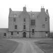
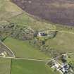
David Bryce was commissioned by Lt Gen Frederick W Traill Burroughs to design this house. Built in the Scottish Jacobean style, three stories high with an attic. The first owner's initials and the date are carved on a panel above the rear door. There is a gateway over the path leading to the kitchen-garden built of sculptured stones found in the vicinity of St Mary's Church and the Wirk. They are high quality architectural fragments, some of 13th century date.

A Ritchie 1996

Site Management (31 July 1992)

Large Jacobean-style Victorian mansion of 3 bays with garret, harled with a slated roof. Corbie-stepped gablets and a canted bay window sit in the south elevation. Side elevations feature crowstepped gables. The rear door features a carved panel with the initials F. W. T. B. and the date 1873. Built to replace Westness House for General Sir Frederick W. Trail-Burroughs (1831-1905) who inherited Rousay and Wyre from his grand-uncle George W. Traill. (ref: Historic Scotland)

Activities

Note (1982)

Westside

Architectural fragments; those that are provenanced are known to have come from the neighbourhood of The Wirk (HY33SE 17) and St Mary's Church (HY33SE 16); now built into an ornamental gateway over the path to the kitchen-garden, with others piled on the W terrace of Trumland House. See Introduction p. 10.

RCAHMS 1982

(RCAHMS 1946, ii, p. 191, No. 549; OR 488)

Publication Account (1996)

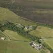
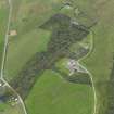
An unusually sheltered spot was chosen for this house, a small valley through which a burn runs down to the sea and where it has been possible to coax woodland to grow. Previously the family seat of the Traill family of Rousay was the 18th-century Westness House (HY 383290), but, after his marriage, Lt Gen Frederick W Traill Burroughs decided to commission the celebrated architect, David Bruce, to design a more imposing residence. The result was a mansion in the Scottish Jacobean style, three storeys high with an attic. The first owner's initials and the date 1873 are carved on a panel above the rear door.

The extraordinary gateway over the path leading to the kitchen-garden is built of sculptured stones found in the vicinity of St Mary's Church and the Wirk (HY 373302; see Rousay excursion). They are high quality architectural fragments, carved of red sandstone, some of 13th-century date and some of 16th-century date, and it is thought that the 13th century pieces may have been 'spares' ftom St Magnus Cathedral. More architectural fragments are built into the east end of the later St Mary's Church, and others were found in the debris of the monastery on Eynhallow (no. 44). The entrance archway into Trumland's home farm is crowned by a tower with a dovecote incorporated into its steep pyramidal roof.

Information from ‘Exploring Scotland’s Heritage: Orkney’, (1996).

Photographic Survey (July 2017)

Trumland House was photographed as part of a photographic survey of the buildings of Rousay. The opportunity was taken to improve the cocerage of this important country house by David Bryce. (STG HES)

References

MyCanmore Image Contributions


Contribute an Image

MyCanmore Text Contributions