
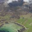
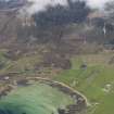
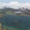
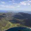
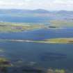
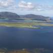
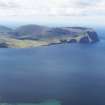
Hoy, General


General View (Period Unassigned), Island (Period Unassigned)
Site Name Hoy, General
Classification General View (Period Unassigned), Island (Period Unassigned)
Canmore ID 265832
Site Number ND29NE 12
NGR ND 25 98
Datum OSGB36 - NGR
Permalink http://canmore.org.uk/site/265832


- Council Orkney Islands
- Parish Walls And Flotta
- Former Region Orkney Islands Area
- Former District Orkney
- Former County Orkney
NMRS REFERENCE:
Orkney Islands, general sites:
Burray, general: ND49NE 36
Eday, general: HY53SE 26
Egilsay, general: HY43SE 16
Flotta, general: ND39SE 65
Hoy, general: ND29NE 12
Mainland, general: HY41SW 248
North Ronaldsay, general: HY75SE 57
Papa Westray, general: HY45SE 100
Rousay, general: HY43SW 49
Sanday, general: HY64SE 111
Shapinsay, general: HY51NW 66
South Walls, general: ND38NW 58
Stronsay, general: HY62SE 39
South Ronaldsay, general: ND48NE 26
Westray, general: HY44NW 0
Ground Survey (October 2013 - October 2014)
In October 2013 a 12 month project began to study the Island of Hoy’s rich WW2 archaeological heritage. The project aimed to determine whether WW2 archaeology could be employed as a community enhancing resource, assess whether this resource could be better utilised to attract tourism, and establish whether it could be utilised as an all-age educational
strategy. A community supported archaeological survey was undertaken to identify and record the extent of surviving WW2 remains on Hoy as well as to encourage and evaluate active adult engagement with wartime heritage through site investigation.
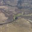
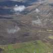
The fieldwork consisted of a focused walkover survey across Hoy and South Walls to verify potential military features identified on post-war aerial photographs from the National Collection of Aerial Photographs and from Cassini grid coordinates recovered from military unit war diaries consulted at The National Archives of the UK. A total of 415 sites specifically relating to WW2 activity on Hoy were recorded during the course of the project, 389 of which were previously unknown; 6 sites were selected for more detailed topographic survey which was primarily used as a public engagement activity.
What was particularly notable from the survey was the number of well preserved sites that have survived predominantly as earthworks. Entire classes of site that were previously absent from the wartime record have been identified, such as anti-aircraft light machine gun pits, defensive firing positions, mortar pits, observation posts and bomb craters. Many of the sites recorded were found to be incredibly well preserved and rank highly amongst the best examples of WW2 military offensive, defensive, supply and support structures in the UK. Three concentrations of military sites around Wee Fea, Lyness and Rinnigill were identified and are considered of such high historic value, that they merit consideration for group protection as conservation areas.
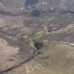
On Wee Fea, the hillside rising up behind the WW2 Naval Base at Lyness, 232 previously unrecorded sites were logged across a 1.5km² area; 156 of these sites were slit trenches c2m long by 1m wide and c1m deep. Some
of the trenches were completely filled with water and others showed signs of partial collapse, erosion or natural infilling. The trenches were supported by 14 weapons pits consisting of mortar pits and light and heavy machine gun positions. A group of three mortar pits near to the summit of Wee Fea are quite remarkable with curved corrugated iron ammunition lockers set into the rear of wedgeshaped pits. Further down the slope of the hill to the E, an incredibly unusual 4m long slit trench with a pair of half
depth corrugated iron Anderson type shelters dug side by side into the rear wall of the trench remains in excellent condition. According to copies of the Hoy Defence Scheme, kept as appendices to the infantry war diaries, Wee Fea formed a distinct sector of an island-wide defence scheme intended to protect vital points, such as the Wee Fea underground oil fuel store and Lyness Naval Base, from attack by the landing of airborne forces or a seaborne commando force. The combined assemblage of prepared defence sites on Wee Fea form a WW2 defence landscape of
unprecedented scale, completeness and preservation and may well represent one of the best surviving examples and densest concentrations of prepared trench positions from WW2 in the UK.
Archive: Island of Hoy Development Trust Office. Report and GIS database: Orkney SMR
Funder: The 12 month position of Wartime Heritage Officer was funded by Scotgrad Graduate Placement Scheme, Highland and Islands Enterprise, Orkney Islands Council Community Development Fund and Heritage Lottery Fund Sharing Heritage Grant.
Gavin J Lindsay – Island of Hoy Development Trust
(Source: DES)

