|
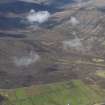
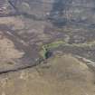
Photographs and Off-line Digital Images |
D 86379 CS |
RCAHMS Aerial Photography |
Aerial view of Hoy showing Bay of Creekland and Bay of Quoys from S. |
4/6/1997 |
Item Level |
|
|
Photographs and Off-line Digital Images |
D 86380 CS |
RCAHMS Aerial Photography |
Aerial view of Hoy showing Bay of Creekland and Bay of Quoys from S. |
4/6/1997 |
Item Level |
|
|
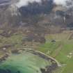
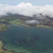
Photographs and Off-line Digital Images |
D 86381 CS |
RCAHMS Aerial Photography |
Aerial view of Hoy, Burra Sound, Bay of Creekland and in the background, Sandy Loch, from ENE. |
4/6/1997 |
Item Level |
|
|
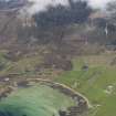
Photographs and Off-line Digital Images |
D 86382 CS |
RCAHMS Aerial Photography |
Aerial view of Hoy, Burra Sound, Bay of Creekland and in the background, Sandy Loch, from NE. |
4/6/1997 |
Item Level |
|
|
Photographs and Off-line Digital Images |
ORD 7/13 |
Copies from a collection of material relating to Inveraray Castle and Estate, Argyll, Scotland |
Photographic copy of part of drawing showing chart of the Orkney Islands. |
1790 |
Item Level |
|
|
Photographs and Off-line Digital Images |
ORD 7/14 |
Copies from a collection of material relating to Inveraray Castle and Estate, Argyll, Scotland |
Photographic copy of part of drawing showing chart of the Orkney Islands. |
1790 |
Item Level |
|
|
Photographs and Off-line Digital Images |
ORD 7/15 |
Copies from a collection of material relating to Inveraray Castle and Estate, Argyll, Scotland |
Photographic copy of part of drawing showing chart of the Orkney Islands. |
1790 |
Item Level |
|
|
Photographs and Off-line Digital Images |
ORD 7/16 |
Copies from a collection of material relating to Inveraray Castle and Estate, Argyll, Scotland |
Photographic copy of part of drawing showing chart of the Orkney Islands. |
1790 |
Item Level |
|
|
Prints and Drawings |
ORD 7/1 |
|
Distribution map of brochs in the Orkney Islands. |
|
Item Level |
|
|
Prints and Drawings |
ORD 7/8 |
|
Ordnance survey map sheet 4, showing S Orkney Islands. |
1910 |
Item Level |
|
|
Prints and Drawings |
ORD 7/9 |
Records of the Royal Commission on the Ancient and Historical Monuments of Scotland (RCAHMS), Edinbu |
Map of the Orkney Islands, showing locations of principal monuments in RCAHMS Inventory. |
1939 |
Item Level |
|
|
Prints and Drawings |
ORD 7/10 |
Records of the Royal Commission on the Ancient and Historical Monuments of Scotland (RCAHMS), Edinbu |
Draft map of the Orkney Islands, showing locations of principal monuments in RCAHMS Inventory. |
1939 |
Item Level |
|
|
Prints and Drawings |
ORD 7/11 |
Records of the Royal Commission on the Ancient and Historical Monuments of Scotland (RCAHMS), Edinbu |
Draft map of the Orkney Islands, showing locations of principal monuments in RCAHMS Inventory. |
1939 |
Item Level |
|
|
Prints and Drawings |
ORD 7/12 |
Records of the Royal Commission on the Ancient and Historical Monuments of Scotland (RCAHMS), Edinbu |
Draft map of the Orkney Islands, showing locations of principal monuments in RCAHMS Inventory. |
1939 |
Item Level |
|
|
Manuscripts |
MS 307/275 |
|
Statistical Account.
Agricultural survey. |
|
Item Level |
|
 |
On-line Digital Images |
DP 060133 |
RCAHMS Aerial Photography Digital |
General oblique aerial view lookings towards the White Glen, Hoy, taken from the N. |
13/5/2009 |
Item Level |
|
 |
On-line Digital Images |
DP 060134 |
RCAHMS Aerial Photography Digital |
General oblique view of the Bay of Quoys with the Howes of Quoyawa beyond, taken from the NE. |
13/5/2009 |
Item Level |
|
 |
On-line Digital Images |
DP 060135 |
RCAHMS Aerial Photography Digital |
General oblique view of the Bay of Quoys with the Howes of Quoyawa beyond, taken from the NE. |
13/5/2009 |
Item Level |
|
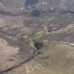 |
On-line Digital Images |
DP 060151 |
RCAHMS Aerial Photography Digital |
Oblique aerial view centred on woodland on the banks of the Burn of Berriedale, taken from the WNW. |
13/5/2009 |
Item Level |
|
 |
On-line Digital Images |
DP 060152 |
RCAHMS Aerial Photography Digital |
Oblique aerial view centred on woodland on the banks of the Burn of Berriedale, taken from the WSW. |
13/5/2009 |
Item Level |
|
 |
On-line Digital Images |
DP 060156 |
RCAHMS Aerial Photography Digital |
General oblique aerial view across North Bay, taken from the E. |
13/5/2009 |
Item Level |
|
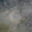 |
On-line Digital Images |
DP 060157 |
RCAHMS Aerial Photography Digital |
Oblique aerial view of Brocken Spectre around the shadow of the aircraft. |
13/5/2009 |
Item Level |
|
|
Manuscripts |
MS 879/125 |
|
Photocopies (A£) of documents in the Public Record Office (National Archives) of maps relating to the islands in Scapa Flow.
from AIR 13/103, 104 and 106 showing barrage balloon positions on Cava, Fara, Flotta and Hoy.
from WO 199/2721 map and documentation on the Ground defence of Cava. |
1940 |
Item Level |
|
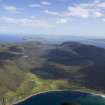 |
On-line Digital Images |
DP 083416 |
RCAHMS Aerial Photography Digital |
General oblique aerial view looking over Rackwick Bay towards the village of Rackwick, taken from the SW. |
6/8/2009 |
Item Level |
|


