
Wyre, St Mary's Chapel


Burial Ground (12th Century), Chapel (12th Century)
Site Name Wyre, St Mary's Chapel
Classification Burial Ground (12th Century), Chapel (12th Century)
Alternative Name(s) St Peters Chapel; Peter's Kirk
Canmore ID 2656
Site Number HY42NW 4
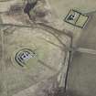
NGR HY 44298 26285
Datum OSGB36 - NGR
Permalink http://canmore.org.uk/site/2656


- Council Orkney Islands
- Parish Rousay And Egilsay
- Former Region Orkney Islands Area
- Former District Orkney
- Former County Orkney
HY42NW 4 44298 26285
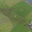
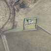
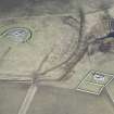
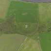
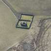
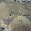
(HY 4430 2628) Chapel (NR)
(remains of)
OS 1:10,000 map, 1977
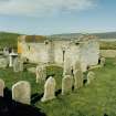
St Mary's Chapel (as shown on DoE (HBM) plaque) is as described and planned. The burial ground has been extended and is still in use. Revised at 1:2500.
Visited by OS (ISS) 13 October 1972.
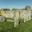
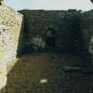
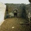
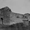
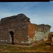
HY 443 262 Recording was undertaken on the S wall of the nave of St Mary's Chapel (HY42NW 4) between July and August 2002. The S wall of the nave currently bulges dangerously outwards, threatening to collapse, thus requiring part of it to be rebuilt.
After the wall was recorded, some of the upper courses were removed. There was some difficulty in being precise about the exact boundary between original stonework, late 19th-century rebuild and 1930s consolidation. This is partly because some of the original stones have been reused, but mostly because of the way the dismantling disturbed, but did not remove, some of the stone, and the way the rebuild interleaves with the original.
Archive to be deposited in the NMRS.
Sponsor: HS
P Sharman, D Murray and G Ewart 2002.
Antiquarian Observation (1846 - 1870)
Plans and drawings by Sir Henry Dryden in folio titled 'Churches in Orkney and Shetland', dated 1846, 1851-2, 1855, 1863, 1866 and 1870 in the Society of Antiquaries of Scotland Collection.
Orkney Smr Note (June 1982)
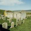
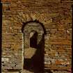
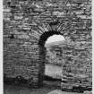
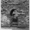
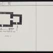
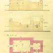
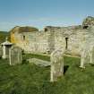
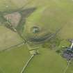
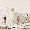
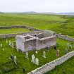
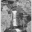
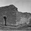
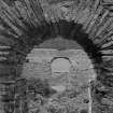
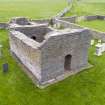
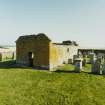
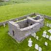
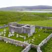
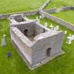
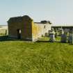
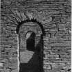
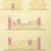
The chapel is a neat Romanesque building comprising nave, 19ft 3in x 13ft and chancel, 7ft 11in x 7ft 3in, with round-arched W entrance door to nave and round chancel-arch. The building is a close parallel to a chapel at Lybster, Caithness and probably dates from the second half of the C12th. It is now more entire than when surveyed by Dryden, according to Craven it was General Burroughs who paid for the initial restoration in the late C19th. Earlier, it was reported as ruinous in the Statistical Account of 1791, and Tudor in 1883 comments on the neglected condition of the churchyard. [R1], [R6], [R10], [R11]
There is some confusion over the dedication of this chapel. The late C16th writer Jo Ben states that the whole island was dedicated to St Peter the Apostle. Dietrichson follows Jo Ben in giving the chapel a dedication to St Peter; Macgibbon and Ross and Anderson give no dedication but call it the Cubberow or Cubbie Row chapel, evidently a localy current name in the C19th; Archdeacon Craven however ascribes it to St Mary, and RCAMS in 1929 were told locally that this is the correct dedication although it was originally attributed to St Peter. The description of Macgibbon and Ross, Anderson and Dietrichson - Anderson in Scotland in Early Christian Times as well as in Orkneyinga Saga - depend heavily on a comprehensive survey made by Sir Henry Dryden in 1866. Muir uses Dryden but makes some drawings himself.
[R2], [R3], [R4], [R7], [R8], [R9]
According to Craven, a font bowl, its interior triangular in shape, and broken into two, had been found at the chapel and was preserved at Trumland House. His drawing shows what appears to be a trough quern. [R5]
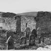
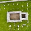
In guardianship, and in good order. Burial ground extended and in use.
Information from Orkney SMR (RGL) Jun 82.
Field Visit (June 1982)
St Mary's Chapel HY 4430 2629 HY42NW 4
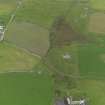
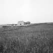
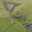
This chapel, which stands at the foot of the hill occupied by Cubbie Row's Castle, has also been called Peter's Kirk; but the Marian dedication was accepted by Archdeacon Craiven and subsequently recorded by RCAHMS in 1929 from a good local source. It is a neat building, close in style and design to the chapel at Lybster, Caithness, and dating from the middle or second half of the twelfth century; the nave has a round-arched W door and a round arch into the square-ended chancel. Ruinous by 1791, it was cleared and partly rebuilt in the late nineteenth century at the instigation of General Burroughs; now in guardianship, and in good order.
RCAHMS 1982, visited June 1982
('Jo Ben', sixteenth century, in Barry 1805, 438; Stat. Acct., vii, 1793, 337, also 1978, 198; Anderson 1873, pp. xcvi-xcvii; Anderson 1881, 60-1; Tudor 1883, 345; Muir 1885, 67 and 114; MacGibbon and Ross 1896-7, i, 113-16; Craven 1901, 74-7; Dietrichson 1906, 122-3 (Norwegian text), 33 (separately paginated English text, summary); RCAHMS 1946, ii, pp. 234-5. No. 618; Radford 1962, 186-7; OR 795)
Publication Account (1996)
This typical Romanesque chapel was built in the 12th century to serve the Christian Norse family whose hall or Bu is remembered in the name of the modern farm, the Bu of Wyre, and for whom Cubbie Roo's Castle (no. 36) was built. Although roofless, it is in good repair not only because it is in State care bur also because it was partially restored in the late 19th century by General Traill Burroughs of Trumland House on Rousay.
Consisting of a rectangular nave and a square chancel, both chancel and have a reentered through semicircular arches, and traces of the original plaster may be seen on the inside walls and, beneath modern hariing, on the exterior. A single window survives high in the south wall of the nave and another in the chancel.
Information from ‘Exploring Scotland’s Heritage: Orkney’, (1996).
Excavation (15 July 2002 - 7 August 2002)
HY 443 262 Recording was undertaken on the S wall of the nave of St Mary’s Chapel (HY 42 NW 4) between July and August2002. The S wall of the nave currently bulges dangerously outwards, threatening to collapse, thus requiring part of it to be rebuilt. After the wall was recorded, some of the upper courses were removed. There was some difficulty in being precise about the exact boundary between original stonework, late 19th-centuryrebuild and 1930s consolidation. This is partly because some of the original stones have been reused, but mostly because of the way the dismantling disturbed, but did not remove, some of the stone, and the way the rebuild interleaves with the original.
P Sharman, D Murray, and G Ewart 2002
Sponsor: Historic Scotland
Kirkdale Archaeology
Excavation (30 June 2009)
HY 4429 2628 As part of survey work to monitor movement of the chapel walls four small holes were excavated around the chapel on 30 June 2009. No finds or features of archaeological significance were recorded in any of the 125mm deep holes.
Archive: RCAHMS (intended)
Funder: Historic Scotland
Andrew Hollinrake – Kirkdale Archaeology
OASIS ID - kirkdale1-249711

