Clachan An Diridh
Four Poster Stone Circle (Bronze Age)
Site Name Clachan An Diridh
Classification Four Poster Stone Circle (Bronze Age)
Alternative Name(s) Clachan Direach
Canmore ID 26308
Site Number NN95NW 5
NGR NN 9251 5574
Datum OSGB36 - NGR
Permalink http://canmore.org.uk/site/26308
- Council Perth And Kinross
- Parish Moulin
- Former Region Tayside
- Former District Perth And Kinross
- Former County Perthshire
NN95NW 5 9251 5574.
(NN 9251 5574) Clachan an Diridh (NAT)
OS 6" map, Perthshire, 2nd ed., (1900)
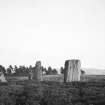
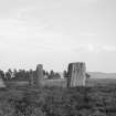
A stone circle, with a diameter of 15'4", called locally Clachan-direach. Three stones are standing, 5'10", 6', and 3'3" in height respectively. Fragments of a demolished fourth stone lie about the ground, but there is no clear indication of its original position.
F R Coles 1908.
Information from RCAHMS emergency survey, 1942
Listed by Burl (1971) as a four poster, a feature for which he suggests a date of c. 1600 BC.
H A W Burl 1971.
The three standing stones described and illustrated and the fragments of a possible fourth are situated in dense afforestation on the shoulder of a slight rise. The largest measures 1.7m high, 1.8m wide and 0.4m thick. The name is now no longer in use and they are now known locally as "The Druids' Stones". This is probably the remains of a "four poster".
Surveyed at 1:10560.
Visited by OS (R D) 16 February 1971.
Field Visit (20 October 1942)
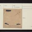
This monument stands at an elevation of about 1150ft above OD, between Lochan na Moine Moire and the track leading from Port na Craig to Tullpowrie. The adjacent ground shows no signs of agricultural improvement. The monument consists of three stones set in the manner shown in the following diagram, that is to say, two, in echelon, 16ft apart, with their major axes to NNE and SW, and another 14ft from both the others, with its major axis NE and SW. It is recorded (Mitchell, 59) that a fourth stone originally existed; nothing remains to show how this stone was placed, and failing this information it is impossible to classify the monument as a circle or a double alignment. The details of the individual stones are as follows:
A. Height, 5ft 10in; breadth 3ft 8in; thickness 1ft 8in in the lower part but less at the top, where the breadth has also been reduce by the formation of a kind of shoulder.
B. Height, 3ft; breadth, 3ft 8in at base, but reduced to 2ft 10in a few inches above ground-level; thickness, up to 8in.
C. Height, 5ft 11in; breadth, 5ft 11in; thickness, 1ft 1in.
See also Dixon, Pitlochry Past and Present pl. 50.
Visited by RCAHMS (AG) 20 October 1942.
[sketch in MS]
Magnetometry (20 August 2012 - 7 September 2012)
Geophysical surveys were conducted at Clachan an Diridh stone circle near Pitlochry in Perth and Kinross. The works comprised high resolution geomagnetic and earth electrical surveys of the stone circle and its immediate vicinity. The works were commissioned by AOC Archaeology Group and conducted by Archaeological Services Durham University.
Information from Oasis (archaeol3-133547) 15 February 2013
Earth Resistance Survey (20 August 2012 - 7 September 2012)
Geophysical surveys were conducted at Clachan an Diridh stone circle near Pitlochry in Perth and Kinross. The works comprised high resolution geomagnetic and earth electrical surveys of the stone circle and its immediate vicinity. The works were commissioned by AOC Archaeology Group and conducted by Archaeological Services Durham University.
Information from Oasis (archaeol3-133547) 15 February 2013
Test Pit Survey (2 October 2012 - 3 October 2012)
NN 9251 5574 A geophysical and laser scan survey of this four-poster stone circle was undertaken 2–3 October 2012. The resistivity and magnetometer surveys indicated that significant buried archaeology extends beyond the visible surface remains. The results of the 3D laser survey were integrated with geophysical results to produce a 3D visualisation of all elements of the site.
Archive: RCAHMS
Funder: Forestry Commision Scotland
Gemma Hudson, AOC Archaeology Group
2012
Project (1 September 2012 - 29 September 2012)
A laser scan topographic survey and geophysical prospection, involving resistivity and magnetometry, was undertaken at Clachan an Diridh ‘four poster’ stone circle on behalf of Forestry Commission Scotland. The geophysical results are inconclusive but may suggest the presence of sub-surface archaeology near the standing stones. The results of the 3D survey above ground were integrated with the geophysical results to produce a 3D visualisation of all elements of the site.
Information from Graeme Cavers, Gemma Hudson, Jake Streatfeild-James
& Duncan Hale (AOC Archaeology) October 2012
OASIS ID: aocarcha1-136133
Earth Resistance Survey (1 September 2012 - 27 September 2012)
Resistivity survey.
Information from Graeme Cavers, Gemma Hudson, Jake Streatfeild-James
& Duncan Hale (AOC Archaeology) October 2012
OASIS ID: aocarcha1-136133
Test Pit Survey (1 September 2012 - 27 September 2012)
A topographic, geophysical and test-pit survey was carried out at Clachan an Diridh four poster in order to assess the potential damage caused by a nearby forestry track, assess the potential for buried archaeological deposits and provide a baseline record of the site.
Information from Graeme Cavers, Gemma Hudson, Jake Streatfeild-James
& Duncan Hale (AOC Archaeology) October 2012
OASIS ID: aocarcha1-136133
Measured Survey (1 September 2012 - 27 September 2012)
A topographic, geophysical and test-pit survey was carried out at Clachan an Diridh four poster in order to assess the potential damage caused by a nearby forestry track, assess the potential for buried archaeological deposits and provide a baseline record of the site.
Information from Graeme Cavers, Gemma Hudson, Jake Streatfeild-James
& Duncan Hale (AOC Archaeology) October 2012
OASIS ID: aocarcha1-136133
Magnetometry (1 September 2012 - 27 September 2012)
Magnetometry survey.
Information from Graeme Cavers, Gemma Hudson, Jake Streatfeild-James
& Duncan Hale (AOC Archaeology) October 2012
OASIS ID: aocarcha1-136133


