Pricing Change
New pricing for orders of material from this site will come into place shortly. Charges for supply of digital images, digitisation on demand, prints and licensing will be altered.
Field Visit


Date 20 October 1942
Event ID 980249
Category Recording
Type Field Visit
Permalink http://canmore.org.uk/event/980249
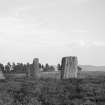
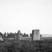
This monument stands at an elevation of about 1150ft above OD, between Lochan na Moine Moire and the track leading from Port na Craig to Tullpowrie. The adjacent ground shows no signs of agricultural improvement. The monument consists of three stones set in the manner shown in the following diagram, that is to say, two, in echelon, 16ft apart, with their major axes to NNE and SW, and another 14ft from both the others, with its major axis NE and SW. It is recorded (Mitchell, 59) that a fourth stone originally existed; nothing remains to show how this stone was placed, and failing this information it is impossible to classify the monument as a circle or a double alignment. The details of the individual stones are as follows:
A. Height, 5ft 10in; breadth 3ft 8in; thickness 1ft 8in in the lower part but less at the top, where the breadth has also been reduce by the formation of a kind of shoulder.
B. Height, 3ft; breadth, 3ft 8in at base, but reduced to 2ft 10in a few inches above ground-level; thickness, up to 8in.
C. Height, 5ft 11in; breadth, 5ft 11in; thickness, 1ft 1in.
See also Dixon, Pitlochry Past and Present pl. 50.
Visited by RCAHMS (AG) 20 October 1942.
[sketch in MS]