
Muir O' Fauld


Watch Tower (Roman)
Site Name Muir O' Fauld
Classification Watch Tower (Roman)
Alternative Name(s) Gask Ridge
Canmore ID 25990
Site Number NN91NE 5
NGR NN 9821 1897
Datum OSGB36 - NGR
Permalink http://canmore.org.uk/site/25990


- Council Perth And Kinross
- Parish Trinity Gask
- Former Region Tayside
- Former District Perth And Kinross
- Former County Perthshire
NN91NE 5 9821 1897
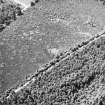
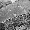
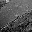
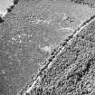
(NN 9821 1897) (OS 6" map annotated by O G S Crawford, 4 July 1925) Roman signal station, partially excavated in 1900. (D Christison 1901) The diameter of the mound is 52'. The ditch is 11' wide on the west side; a causeway 8' 6" wide and 9' long leads across it towards the road.(O G S Crawford 1949)
A Flavian date is suggested. (A L F Rivet 1964)
Clearly visible in 1964 (OS 6"map annotated by A L F Rivet, 19 January 1964)
D Christison 1901; O G S Crawford 1949; A L F Rivet 1964.
A signal station, generally as described above. There is a low, spread, outer bank.
Surveyed at 1/2500.
Visited by OS (W D J) 1 August 1967.
There is no change to the existing record.
Visited by RCAHMS (IF), 7 November 1995.
Publication Account (1987)
The watch-towers in this sector were intended to control movement on the road between Strageath and Bertha, and the system may have been continued south to Ardoch and perhaps further. They should be seen as a sort of linear frontier, an early precursor of more complex barriers such as the Antonine Wall, but they were also distinct elements in a surveillance system of roadside installations which controlled movement of the native population into and out of Fife. For example, it has been suggested that the towers between Ardoch and Kaims Castle (no. 82) may also have served as a forward line of communication for the fort at Ardoch; these watch-towers have two ditches and thus appear to belong to a group distinct from the Gask Ridge series. The towers, separated by intervals which range from about 0.8 km to 1.5 km were some 3.5 m square with stout corner-posts, and excavations have revealed that some of these posts were connected by sleeper-trenches to provide additional support for the superstructure-a two-storey signalling tower of the type clearly illustrated on Trajan's Column; the pits in which these posts stood may be seen on the air photograph of Westerton (NN 873145); in some examples the tower was surrounded by an earthen rampart, probably surmounted by a timber breast-work, and by a ditch (over 3 m wide and at least 1 m deep), occasionally with an outer bank. The ditch was interrupted opposite the entrance (also visible on the air photograph) to allow access from the road; an indication of the road-line is given on the photograph by the roadside quarry-pits seen as dark patches. The general appearance of the watch-towers is shown in the reconstruction drawing, reminding us perhaps that although the surviving traces are slight, the towers once formed part of an effective military communications-system, which successfully imposed Roman control over east-central Scotland.
Among the best preserved and most accessible sites are those listed below.
Muir O' Fauld (NN 982189) HBM (SDD). Park at the entrance to the forestry road at NN 985191 and walk to the west along the track (on the line of the Roman road) for 350 m; the watch-tower is sign posted to the south of the track in a fenced enclosure. The rampart, ditch, causeway and outer bank can be seen.
Information from ‘Exploring Scotland’s Heritage: Fife and Tayside’, (1987).

