
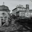
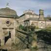
Glasgow, Pollokshaws Road, Pollok Park, Pollok House, Eastern Garden Pavilion


Pavilion (20th Century), Tunnel Chamber (Post Medieval), Well Head (Period Unknown)
Site Name Glasgow, Pollokshaws Road, Pollok Park, Pollok House, Eastern Garden Pavilion
Classification Pavilion (20th Century), Tunnel Chamber (Post Medieval), Well Head (Period Unknown)
Canmore ID 259435
Site Number NS56SW 31.09
NGR NS 54907 61802
Datum OSGB36 - NGR
Permalink http://canmore.org.uk/site/259435


- Council Glasgow, City Of
- Parish Eastwood (City Of Glasgow)
- Former Region Strathclyde
- Former District City Of Glasgow
- Former County Lanarkshire
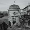
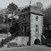
Lodge, Pollok House, 97 Haggs Road, 1892, R Rowand Anderson. Scottish classical with shallow conical slate roof over a broad semicircular bay window. Shawmuir Lodge, Pollok Avenue, 2060 Pollokshaws Road, 1891, Robert Rowand Anderson. Scots Classical Lodge with bell-cast slate hipped roof. Tall square gatepiers with urns and decorative wrought-iron gates. Estate Bridge over River Cart, 1757. Single wide segmental arch, balustraded parapet, roadway widens at abutments. Stables Range, 17th to 19th century. Courtyard Range on site of previous house, the Laigh Castle, includes handsome Renaissance gateway (north-west side) and more 17th-century work incorporated into later buildings. Weir, Sawmill and Power Station, c.1860 for Sir John Stirling-Maxwell. Weir may be 18th century. Single-storey brick sawmill with early machinery, although a turbine replaces the low-breast water wheel. Late 19th-century Power Station, with Waverley turbine by Carrick & Ritchie of Edinburgh.
Taken from "Greater Glasgow: An Illustrated Architectural Guide", by Sam Small, 2008. Published by the Rutland Press http://www.rias.org.uk

Excavation (22 June 2009 - 26 June 2009)
NS 549 618 Prior to this year’s survey the Land Services team for Pollok Country Park had informed Glasgow Archaeological Society of the existence of a sandstone-lined chamber sealed by an iron manhole cover beside the main entrance to Pollok House (NS56SW 31.0). As estate maps show no record of a well or cistern at this location the chamber was included in this year’s work.
The modern manhole cover sits on top of a brick and concrete base, c0.75m high by 1.2m square. The chamber itself is c5m deep and 3m wide and contained water to a depth of 2m. The true depth of the cistern or well is unknown as depth measurements taken with a weighted line indicated a layer of black slit below the present water level. The chamber is constructed of tight-fitting sandstone ashlar blocks, which do not appear to have weathered or decayed even though there is extensive tree root ingress. This stone work is the same heavily occluded sandstone or Barrhead Grit as was recorded during the stable block survey and appears to have been locally quarried. A timber beam c3.5m long by 0.5 x 0.5m has been deposited within the chamber.
Further investigation on the surface recorded a large sandstone block approximately 3m from the manhole cover. The initial view had been that the concrete base of the manhole extended out c1 or 2m from the base of the modern cover. However, further investigation revealed that the sandstone block extended back to the manhole base and appeared to be completely intact.
Further clearing of the topsoil eventually revealed a sandstone disc in six separate pieces, consisting of two full quarters on the western side of the disc and four shaped plates on the eastern side which are joined together by a clay mortar bond. This sandstone is not the same material as the chamber lining; it is a more common ‘bed’ sandstone, which was readily available throughout the region in the 17th–20th centuries. The original rippled bed face is exposed on five of the six segments. The sixth, in the north-eastern section, is the worked face and a smooth surface is presented on this section.
Once the disc had been cleared two slots were dug, on the north-western and south-western edges, to investigate the depth of the stone slabs used in the construction of the feature. On re-opening the manhole the edges of the disc plates were recorded and measured. The sections were approximately 0.4m deep. The modern access is placed above an earlier cut in the stonework to allow access into the chamber below.
While the surface of the disc was fully exposed, two 1m long by 7.5mm slot trenches were dug. The limited number was to ensure that the structural integrity of the well cap was not compromised. The sandstone slabs measured 0.4m deep and the disc at its widest point is 4m. It was calculated that the entire well cap weighs c11.6 tonnes. On the northern top quarter disc a hole appears to have been cut into the disc and then filled in with a similar clay mortar bond. The function and purpose of this cut is not readily understood, though it may be associated with some form of pumping mechanism that was placed above the chamber after the cap was put in place. The slot on the SW side contained several small finds, including three pieces of green glaze pottery dated to the 14th or 15th century as well a cut slate and fragmentary remains of a green glass bottle. Substantial rubble remains were also found in this slot. The slots also showed that the cap was sitting proud of the actual cistern/well and the wellhead was visible below the cap. However, the regularised stone used within the visible part of the wellhead immediately below the cap appears to be the same phase of construction as the
well cap.
The interpretation of these two structures and associated small finds is complex. The dimensions of the stone-lined chamber do not appear to indicate a well, when compared to the other known wells within the confines of the modern Country Park. The stonework observed in the chamber is too regularised in its cut and build quality to indicate a pre 17th- or 18th-century structure. However, that is not to say that it does not have an earlier origin than the one suggested, as there is a strong association between Pollok and St Conal from before the 12th century, including a well (NS56SW 18) dedicated to St Conal in the immediate vicinity.
The recovery of 14th- and 15th-century green glaze pottery fragments adjacent to the cistern or well is not indicative of an earlier phase of activity, however, as later glasswork was also recovered from the same area. These finds were deposited with building rubble and this appears to indicate that the fill around the wellhead may be made up of material from several phases of activity, which may even pre-date the site. Also, due to the sites proximity (c30m), to the entrance to Pollok House, it is likely that there have been multiple phases of landscaping from the 18th century onwards.
The chamber is most likely to be associated with the 17th-century Pollok House, which is shown on Robert Ogilvy’s 1741 estate plan to be close to the site. It may either be a cistern associated with agricultural activity, a cold house for the house or part of a drainage system. The well cap is of considerable interest due to its size and scale. It appears to be too large to be a simple cap for the chamber and may represent another phase of activity in the 18th or 19th century, when there is a possibility that the chamber and the cap were used as an ornamental garden feature, which may explain the slate and rubble recovered in the SW slot trench. The timber
beam in the chamber is too well preserved to be of any great antiquity and may have been deposited when the modern manhole cover was put in place.
The site was fully recorded (including photographically and topographically) and a 1:20 scale plan of the well cap including the modern manhole was made. The structure’s position was also recorded on a GPS. The site was covered with sand after the work was completed to protect it from the elements while Glasgow City Council conducted a structural engineering report on the well cap and cistern, with a view to permanently displaying this monument to the general public. This work was undertaken on 22–26 June 2009.
Archive: RCAHMS (intended)
Funder: Glasgow Archaeological Society
Mark Mitchell and Stephen Driscoll – Glasgow Archaeological Society
Excavation (19 September 2009 - 26 September 2009)
NS 549 618 Following fieldwork in June 2009 a limited excavation of a 5 x 5m trench on the NW side of the well cap was undertaken on 19–26 September 2009. Several deposits associated with the well cap were recorded including a dump of shaped sandstone, the largest piece 1 x 0.4m by 0.25m deep, which appears to be associated with an earlier phase of activity around the well or cistern head itself. An incomplete field drain was also uncovered, which terminated against upper courses of the western side of the cistern chamber. Small finds consisted of a variety of green glaze pottery dated to the 14th or 15th century, 17th- to 19th-century
glazed pottery, three types of roofing slate, three types of roof nail including round, square and triangular heads, early 20th-century shotgun cartridges and glassware ranging from the 17th to the 20th century. Two samples of mortar, clay and the other sandstone were also recovered from the site. The base of a 17th-century glass vessel was recovered from the sandstone mortar sample, which was still attached to the shaped stone described earlier.
The site stratigraphy appears to indicate that the well cap placement took place in one phase, with the chamber and the surrounding ground level being raised by at least 1m in places. Below the main context of this fill was a layer of grey boulder clay. This construction phase has, however, made accurate sequencing of the wellhead difficult due to the associated dumping and re-depositing of material in the area of the excavation.
While the well cap excavation was taking place a small magnetometer and topographic survey was undertaken directly to the N and E of the site. The survey consisted of five full 20 x 20m square grid and one 10 x 20m ‘half grid’ utilising an FM-16 fluxgrade magnetometer recording at 1m intervals.
The topographic survey recorded the position of these grids, the position of the well cap and the trench features and edges. The geophysical survey revealed several possible building features within the area and these appear to be consistent with structures shown on the 1741 estate plan.
Archive: RCAHMS (intended)
Funder: Glasgow Archaeological Society
Mark Mitchell and Stephen Driscoll – Glasgow Archaeological Society

