
Edinburgh, The Crawley Tunnel


Pipeline (Period Unassigned), Tunnel (Period Unassigned)
Site Name Edinburgh, The Crawley Tunnel
Classification Pipeline (Period Unassigned), Tunnel (Period Unassigned)
Alternative Name(s) Water Tunnel; Water Pipeline; Glencourse Reservoir To The Mound
Canmore ID 259410
Site Number NT27SE 5844
NGR NT 2569 7328
NGR Description NT c.2567 7282 to NT c.2536 7385
Datum OSGB36 - NGR
Permalink http://canmore.org.uk/site/259410


- Council Edinburgh, City Of
- Parish Edinburgh (Edinburgh, City Of)
- Former Region Lothian
- Former District City Of Edinburgh
- Former County Midlothian
NT27SE 5844 from c. 2567 7282 to c. 2536 7385
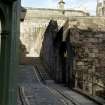
The former aqueduct known as the 'Crawley Aqueduct' which runs from approximately from The Meadows to a point near the foot of The Mound (NT27SE 923). The aqueduct was built in 1821, around the same time as Glencorse Reservoir (NT26SW 63.00), and took a line from The Meadows under the Royal Infirmary (NT27SE 480.00) and the Grassmarket to the foot of The Mound. A further section possibly runs through to Scotland Street.
A small section of the tunnel was revealed during road excavations in Princes Street in 1958, the hole being subsequently filled in afterwards. Sections of the tunnel still survive underground.
Information from RCAHMS (DE), June 2004.
Watching Brief (2013)
The Crawley Tunnel is an aqueduct that runs approximately from The Meadows to at least Hannover Street and crosses Princes Street at the foot of The Mound. Built about 1821 to house the pipes bringing water into Edinburgh, the structure consists of stone walls with an arched stone roof. Previously a small section of the tunnel was revealed during road works
on Princes Street in 1958, when the roof of the tunnel was damaged and the resulting hole repaired. The archaeological works carried out during construction for the Edinburgh Tram network was initially intended to record an exposed length of the Crawley Tunnel. However, further sections of the main tunnel and part of a second tunnel were revealed, necessitating
further archaeological work both on these structures and on previously unrecorded Victorian drains adjacent to the tunnels.
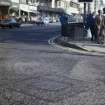
A 15 m long section of the Crawley Tunnel was exposed where it crosses Princes Street, the tunnel curves round from the foot of the Mound across Princes Street before continuing along the east side of Hannover Street. The roof and sides of the tunnel was cleaned and examined and several features were noted in the fabric including an area that had been damaged and patched with concrete and concrete kerb stones. Other features noted on the structure include a truncated section that was capped by a concrete base topped with brick build culverts. The culverts ran towards another section at the corner of the Mound that had been re-built in brick over the original stone walls and was capped with steel plates bolted to the brick and concrete walls. The extent of the tunnel affected by the tram
works was exposed and cleaned, during which process areas of damage, repair and rebuilding were revealed. The damaged and repaired section consisted of an area of approximately 1.5 m by 2m and had been repaired using concrete kerbstones, bricks and concrete. In other areas of the tunnel roof grooves for services and pipes had been gouged out of the stonework while other areas had been damaged by the construction of foundations and culverts associated with the earlier tram lines.
As the exposed section of the tunnel would carry the new tram lines on Princes Street, the existing tunnel structure was not suitable therefore once the tunnel was recorded the arched roof was removed and replaced with a reinforced concrete slab.
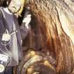
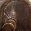
Access into the tunnel was established at the foot of the Mound at a point where the roof consisted of curved steel plates bolted together and fitted into supporting iron girders. Each steel plate was 1.6m by 1.07m and 15m thick with a 0.3 m circular plate in the centre attached by five bolts. These plates covered a circular hole each circular plate had three bolts forming a
bracket on the underside (inside the tunnel) possibly to hold a pipe. Two of the plates bolted together and supported on girders spanned the chamber. Each plate was curved across the width to give a bend of 0.12m at the centre. When the plates were removed two small squares were cut out of the plates so that chains could be attached, each of these squares 140mm by 140mm weighed 2.212kg which gives an indication of the scale of the engineering involved. A possible original manhole was identified in the roof at the north end of the chamber, this was built from girders and sealed with short lengths of similar iron girders with concrete and brick. A five metre section of the steel roof was removed to reveal a brick built chamber with walls 2m high that was 2m wide at the north end but widened to nearly 3m at the south with a narrow chamber off to the west. The lower section of the east wall consists of four courses of presumably the original stone wall of the tunnel but the upper portion is built of 11 courses of brick. The west wall is built completely from bricks (21 courses) and has seven square metal fittings attached to it. These fittings are 0.6m by 0.6m with a square recess in the middle and a bracket at the bottom. These fittings continue beyond the limits of the chamber to the north where there are similar fittings on the east wall too. These fittings presumably relate to testing or maintenance of the pipework. As part of the current work a new pipe had been inserted through the west wall into the chamber. To the north the chamber continued with a steel plate roof before reverting back to the arched tunnel. At this point the arch and ‘mouth’ of the tunnel is built of brick and a metal gate has been inserted to block off access to the tunnel. The tunnel section on the south-east corner of Princes Street and the Mound appears to have been rebuilt as the walls had been built in brick, while one area of the roof consisted of curving
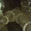
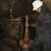
iron sheets that had been bolted to the walls. The tunnel was recorded by chemical and digital photography, by measured drawing and by written description. A large iron water pipe that runs down the west side of the Mound and links across to the pipes within the Crawley Tunnel was replaced during these works, and a large stone built drain was uncovered directly beneath the existing pipe, the uncovered drain was photographed and recorded prior to being dismantled. The drain comprised two irregular-coursed masonry walls, each 0.3 m thick and about five courses high (0.65 m). The interior faces were well made and vertical while the exterior faces were irregular. The walls were built over a stone base slab and were capped by large flat stones. The interior of the drain was completely filled with a deep deposit of grey gritty silt with frequent inclusions of gravel. The base of this deposit consisted of orange/brown grit.
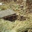
As archaeological recording of the Crawley Tunnel was being completed, another similar section of tunnel was uncovered to the east immediately to the north of the Royal Scottish Academy. As work continued it appears that this tunnel joins with the first tunnel at the foot of Hannover Street as at the northern limit of the excavation both tunnels converge. Due to the construction programme and disturbance caused by the later insertion of deep sewers with manholes that cut through the tunnel, it was not possible to investigate the full length of the tunnel as it crossed Princes Street. Similarly although the tunnel appeared to continue under the pavement and even under the Royal Scottish Academy building this was not confirmed as this section was not affected by tram construction works and remained undisturbed (the presence of live services along the pavement edge also meant it was not possible to investigate further in this
area). The section of tunnel investigated was approximately 10 m long north-south, at some point in the past the stone roof had been partly removed and the tunnel completely filled in with earth and rubble. This material, was removed by machine under archaeological supervision,
was sifted and investigated using a metal detector in order to retrieve any datable artefacts. Once the section of the tunnel had been emptied it was cleaned and recorded. The tunnel roof was 1.7 m high and 1.5 m wide (internally) with a small chamber off the east side. The north end was blocked by the insertion of a deep stone built manhole that connected with a sewer 5m below that was still in use, another manhole this time made from concrete had been cut into the west wall of the tunnel. The floor, walls and roof of the tunnel were built of rectangular coursed sandstone masonry with an arched roof. The building stones were on average 0.9 m by 0.25 m by 0.3 m.
On the east side of the tunnel was a small chamber 3.4 m by 1 m, the roof of which consisted of large rectangular flat stone slabs up to 1.8 m by 0.5 m by 0.2 m. These slabs were removed along with the soil and rubble that partly filled the interior. This revealed that some of the stones forming the floor had been removed to reveal a light brown clay subsoil and that a large
steel pipe had been inserted through the north wall. At the doorway in the south west corner linking the room with the main tunnel, the stones had been cut away and the wall face angled presumably to facilitate running the pipe through and along the tunnel to the south. At the north end of the tunnel another pipe had been inserted through the west wall and part of the
east wall opposite had also been cut away. This second tunnel was different from the other tunnel in that the walls were higher (internal
dimensions 1.7 m high and 1.5 m wide while the main Crawley Tunnel was 1.4m high and 1.5m wide). The Royal Scottish Academy was built between 1822-26 and is therefore contemporary with the construction of the Crawley Tunnel as construction started in 1821 and it maybe that
the two tunnels reflect a change in the design or route to accommodate the building of the Royal Scottish Academy the tunnel being diverted to the Mound.
Once the tunnel and side chamber was recorded the stonework was protected by geotextile and the tunnel completely filled in with gravel.
Information from Christine Rennie and Bob Will (GUARD Archaeology) 20 February 2013. OASIS ID: guardarc1-171032
Watching Brief (21 January 2014)
An archaeological evaluation was undertaken by AOC Archaeology Group on behalf of Cala Homes (East) prior to the redevelopment of a brownfield site at Burdiehouse Road, Edinburgh. The evaluation comprised the machine excavation of single trench positioned across the suspected line of the early 19th Century Crawley Tunnel. The trench measured c.0.80 m wide by c.3.2 m deep and extended for nearly 13.0 m. The trenching revealed a thin modern topsoil over c. 0.5 m to 1.0 m of redeposited clay over what appeared to be natural clay subsoil which at 3.0 m became in situ weathered bedrock. No trace of the Crawley Tunnel was encountered within the trench and beyond some disturbance within the upper 1.0 m of deposits there was no indication that it had been removed. It maybe that the tunnel lies outwith the area available for investigation which was limited by existing properties and trees. Alternatively the construction of the present residential properties on the site, built in the latter half of the 20th century may have removed all trace of the tunnel.
AOC Archaeology 2014 (L. Dunbar) OASIS ID: aocarcha1-170268
Note (1 October 2014)
A water pipeline runs from Glencourse Reservoir to the mound and possibly Leith. Built by the Edinburgh Water Works/Edinburgh and District Water Trust, it was often referred to as the Crawley Tunnel, although through most of its distance it was actually a cast iron pipeline.
For related sites see
NT26SW 63 & 143
NT26SE 165
NT26NE 346
NT27SE 5844, 6016
Information from RCAHMS (AKK) 1 October 2014.
Note (1 October 2014)
Changed classification from Aquaduct to pipeline.
Information from RCAHMS (AKK) 1 October 2014.

