
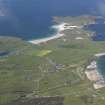
Faraid Head, Rotor Centrimetric Early Warning Radar Station


Quarry(S) (Period Unknown), Radar Station (20th Century), Wall (Period Unknown)
Site Name Faraid Head, Rotor Centrimetric Early Warning Radar Station
Classification Quarry(S) (Period Unknown), Radar Station (20th Century), Wall (Period Unknown)
Alternative Name(s) Leae Fir Dhuirnis
Canmore ID 257707
Site Number NC37SE 4
NGR NC 3880 7158
NGR Description Centred NC 3880 7158
Datum OSGB36 - NGR
Permalink http://canmore.org.uk/site/257707


- Council Highland
- Parish Durness
- Former Region Highland
- Former District Sutherland
- Former County Sutherland
NC37SE 4 centred 3880 7158
Loran Radar station visible on vertical air photographs (V 540/RAF/1631, 0075-077, flown 1 June 1955) at Faraid Head. Several buildings shown on current OS digital 1:2500 scale map.
Information from RCAHMS (DE), May 2004
Information supplied by Mr Ian Brown (Radar Archive) confirms this installation as a ROTOR Radar Station. Built as part of the ROTOR Plan. The station is of postwar date.
Information to RCAHMS via e-mail from Mr I Brown, 13 December 2008.
Field Visit (6 August 2008)
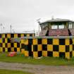
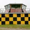
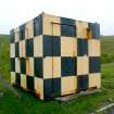
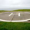
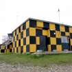
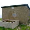
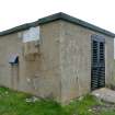
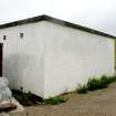
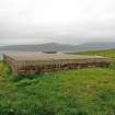
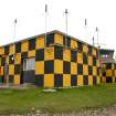
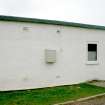
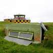
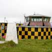
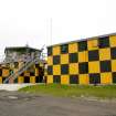
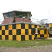
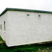
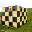
The Cape Wrath Training Centre (CWYC) range control facility on Faraid Head currently comprises a fenced compound, some 9ha (c.22 acres) in size, which contains a number of buildings, a helicopter landing pad and a large area of hard standing. The principal building (CWTC08 282) is the range control tower, which stands on the highest part of the peninsula and is a converted Type 80 modulator building originally built as part of the CEW R10 ROTOR radar station established here in the mid 1950s. The gantry that once supported the radar assembly above the south-west end of the building has been completely removed, and the squat hexagonal observation tower that we see today is a later addition. All of the original fittings have been removed from the interior, which has been refurbished to provide offices and accommodation for range control staff.
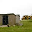
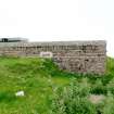
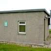
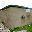
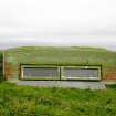
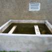
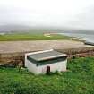
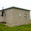
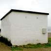
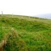
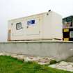
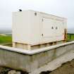
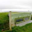
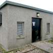
In addition to the modulator building, the original ROTOR complex included several other buildings, the locations of which are captured on vertical aerial photographs taken by the RAF in June 1955 (V 540/RAF/1631, 0075–6). One of these buildings (CWATA08 285), now containing a fuel storage tank, stands 60m north-east of the modulator building. A larger building beside it (CWTC08 284), presently housing a generator, is of more recent construction. An original building (CWTC08 004), which stood at the north end of the compound, has been reduced to little more than a thin spread of rubble, while the site of another on the east side (CWTC08 06) is indicated now by nothing more than a grass-grown platform cut into the slope. Immediately to the SSW of the modulator building is another building (CWTC08 293) that has also been reduced to little more than a platform, while next to the modulator building is a brick-built water tank with a hatch in its concrete roof (CWTC08 295). Two observation buildings (CWTC08 280-1), which have been set into the cliff-top immediately W of the main building, probably date to when the facility became the control centre for the Navy bombing range.
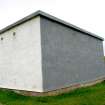
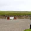
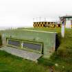
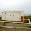
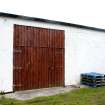
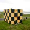
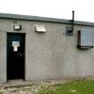
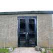
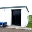
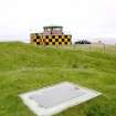
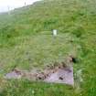
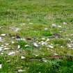
The largest building in the original complex, the R10 Operations Block, stood in the large natural hollow below and about 120m south-east of the modulator building. Remains of this structure and several others close-by survived (at least as footings or concrete floors) until as recently as 2004, when they were photographed from the air by RCAHMS (E40881–6; E43577–9). Since then, however, most have been bull-dozed to form the hard standing that provides a solid footing for artillery pieces firing across the kyle onto a target area (NC37SW 29) on the east flank of Sgribhis-bheinn. Two of the buildings, both now in use as stores, survive intact, one (CWTC08 286) at the east end of the hard standing, the other (CWTC08 287) at the SW corner. The sentry post (CWTC08 288) at the gate in the SW corner of the compound is a steel container that has been placed there since 2004. However, it stands on the site of the original sentry post.
Examination of the 1955 aerial photographs makes it clear that all of the buildings were linked by a network of tracks and cable trenches, then recently dug. Some of these features are still visible today, though grassed over, but they were not recorded by the present survey. Several other features which are visible on the aerial photographs have left little or no trace on the ground; conversely, there are features visible on the ground today which are not apparent on the photographs and must, therefore, post-date the initial use of the ROTOR radar station.
(CWTC08 01–08, 276–88, 293–5, 299)
Visited by RCAHMS (JRS, JH, IP, AL), 4 August 2008.

