 |
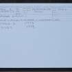
On-line Digital Images |
SC 2390728 |
Records of the Ordnance Survey, Southampton, Hampshire, England |
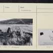
Carse Farm, NN84NW 4, Ordnance Survey index card, page number 1, Recto |
c. 1958 |
Item Level |
|
 |
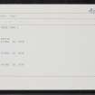
On-line Digital Images |
SC 2390729 |
Records of the Ordnance Survey, Southampton, Hampshire, England |
Carse Farm, NN84NW 4, Ordnance Survey index card, page number 1, Recto |
c. 1958 |
Item Level |
|
 |
On-line Digital Images |
SC 2390730 |
Records of the Ordnance Survey, Southampton, Hampshire, England |
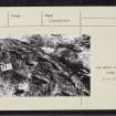
Carse Farm, NN84NW 4, Ordnance Survey index card, page number 2, Verso |
c. 1958 |
Item Level |
|
 |
On-line Digital Images |
SC 2390731 |
Records of the Ordnance Survey, Southampton, Hampshire, England |
Carse Farm, NN84NW 4, Ordnance Survey index card, page number 2, Verso |
c. 1958 |
Item Level |
|
 |
On-line Digital Images |
SC 2390732 |
Records of the Ordnance Survey, Southampton, Hampshire, England |
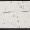
Carse Farm, NN84NW 4, Ordnance Survey index card, Recto |
c. 1958 |
Item Level |
|
 |
On-line Digital Images |
SC 2390733 |
Records of the Ordnance Survey, Southampton, Hampshire, England |
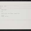
Carse Farm, NN84NW 4, Ordnance Survey index card, Recto |
c. 1958 |
Item Level |
|
 |
On-line Digital Images |
SC 2390734 |
Records of the Ordnance Survey, Southampton, Hampshire, England |
Carse Farm, NN84NW 4, Ordnance Survey index card, Recto |
c. 1958 |
Item Level |
|
 |
On-line Digital Images |
SC 2390735 |
Records of the Ordnance Survey, Southampton, Hampshire, England |
Carse Farm, NN84NW 4, Ordnance Survey index card, Recto |
c. 1958 |
Item Level |
|
 |
On-line Digital Images |
SC 2390736 |
Records of the Ordnance Survey, Southampton, Hampshire, England |
Carse Farm, NN84NW 4, Ordnance Survey index card, Recto |
c. 1958 |
Item Level |
|
 |
On-line Digital Images |
SC 2390737 |
Records of the Ordnance Survey, Southampton, Hampshire, England |
Carse Farm, NN84NW 4, Ordnance Survey index card, Recto |
c. 1958 |
Item Level |
|
 |
On-line Digital Images |
SC 2390738 |
Records of the Ordnance Survey, Southampton, Hampshire, England |
Carse Farm, NN84NW 4, Ordnance Survey index card, Recto |
c. 1958 |
Item Level |
|
 |
On-line Digital Images |
SC 2390739 |
Records of the Ordnance Survey, Southampton, Hampshire, England |
Carse Farm, NN84NW 4, Ordnance Survey index card, Recto |
c. 1958 |
Item Level |
|
|
Photographs and Off-line Digital Images |
SC 2756524 |
Papers of Dr Margaret E C Stewart, archaeologist, Perth, Scotland |
Cinerary urn with other artefacts |
1967 |
Item Level |
|
|
Photographs and Off-line Digital Images |
SC 2756525 |
Papers of Dr Margaret E C Stewart, archaeologist, Perth, Scotland |
Cinerary urn |
1967 |
Item Level |
|
|
Photographs and Off-line Digital Images |
SC 2756731 |
|
Stone Circle |
1972 |
Item Level |
|
|
Photographs and Off-line Digital Images |
SC 2756732 |
|
Stone Circle |
1972 |
Item Level |
|
|
All Other |
BS 171 |
General Collection |
Slides relating to excavations and research by Professor J M Coles:
Coles Photographs BS 171
1 – 2 Culbin (no date)
3 – 5 Kilmelfort (no date)
6-8 Grandtully (Apr 67)
9-33 Morton
34-48 Miscellaneous Metal Artefacts
49-115 Pitnacree
116 - 118 Lundin Links to N.
119 Dreva to NE.
120 - 121 View from Craik Moor
122 Drumchesters to E. Stone huts
123 Craigie Hill fort. Hut circle…..?
124 Traprain Law
125 - 129 Courthill Dalry
130 Balbirnie circle to SE
131 Balbirnie Cist with C & ring
132 Dowally
133 - 134 Cairnpapple to NW
135 Dunmore NO0724 4198
136 Nether Largie South Cairn Neo.
137 – 138 Balnaguard
139 Inchyra
140 Ardestie Angus souterrain
141 Woden Law
142 – 143 White Meldon
144 - 146 Balfarg
147 Little Trochrie
148 -149 Shien Hill
150 Castlelaw fort view to SW. Souterrain on left.
151 Torwoodlee broch to S
152 -153 Mains of Fordie
154 from White Castle. Traprain
155- 158 Carse group
159 Kindallachan barrow
160 Fortingall barrow
161 Huntingtower Perthshire
162 Strathtay
163 -165 Fortingall
166 -168 Croft Moraig 1974
169 Jura st. stone at Tarbert Lodge
!70 -171 Ballinluig
172 Mains Kenmore (Taymouth) east. 30 by 18m by 2.5m ht.
173 Collessie Fife
174 Gall (Gauls)
175 Ninewells |
c. 1970 |
Batch Level |
|
|
All Other |
551 490/1/2/4/13/1 |
Historic Scotland Photographic Library |
Dull Perthshire, Gnerary Urn |
12/10/1970 |
Batch Level |
|
|
All Other |
551 166/1/1 |
Records of the Ordnance Survey, Southampton, Hampshire, England |
Archaeological site card index ('495' cards) |
1947 |
Sub-Group Level |
|
|
All Other |
551 490/1/2/4/13 |
Historic Scotland Photographic Library |
Carse Farm, Dull, Perthshire |
|
Sub-Group Level |
|


