
Brae Of Murthly


Farmstead (Period Unassigned)
Site Name Brae Of Murthly
Classification Farmstead (Period Unassigned)
Alternative Name(s) Pittiely Burn
Canmore ID 25607
Site Number NN84NE 41
NGR NN 8774 4818
Datum OSGB36 - NGR
Permalink http://canmore.org.uk/site/25607


- Council Perth And Kinross
- Parish Logierait
- Former Region Tayside
- Former District Perth And Kinross
- Former County Perthshire
NN84NE 41 8774 4818.
Formerly also entered as NN84NE 56.
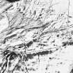
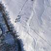
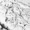
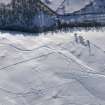
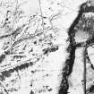
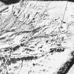
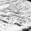
(NN 8774 4818) Brae of Murthly deserted village.
(Undated) information from M E C Stewart to OS.
A farmstead comprising one roofed building is depicted on the 1st edition of the OS 6-inch map (Perthshire 1867, sheet xlix).
Information from RCAHMS (RHM), 7 November 1996
A farmstead comprising two roofed, two unroofed buildings and six conjoined enclosures is depicted on the 1st edition of the OS 6-inch map (Perthshire 1867, sheet xlix).
Five unroofed buildings and an incomplete enclosure are shown on the current edition of the OS 1:10000 map (1977).
Information from RCAHMS (SAH), 5 November 1997.
Standing Building Recording (22 August 2013 - 2 September 2013)
NN 8774 4818 (centred on) A standing building survey was carried out, 22 August – 2 September 2013, in advance of the construction of a house, which required the demolition of two ruinous dry stone structures in the SE of the site. A photographic survey recorded the general details and character of the structures. The other farmstead buildings, lime kilns and cup-marked stone have been demarcated and will not be affected by the development.
Archive: RCAHMS (intended)
Funder: David Wilson
Graeme Brown, Alder Archaeology Ltd, 2013
(Source: DES)

