|
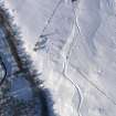
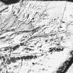
Photographs and Off-line Digital Images |
D 59389 |
RCAHMS Aerial Photography |
Oblique aerial view of the remains of the farmsteads and field banks, taken from the NW. |
12/2/2001 |
Item Level |
|
|
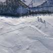
Photographs and Off-line Digital Images |
D 59390 |
RCAHMS Aerial Photography |
Oblique aerial view of the remains of the farmsteads and field banks, taken from the NW. |
12/2/2001 |
Item Level |
|
|
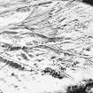
Photographs and Off-line Digital Images |
D 59391 |
RCAHMS Aerial Photography |
Oblique aerial view of the remains of the farmsteads and field banks, taken from the W. |
12/2/2001 |
Item Level |
|
|
Photographs and Off-line Digital Images |
D 59392 |
RCAHMS Aerial Photography |
Oblique aerial view of the remains of the farmsteads and field banks, taken from the WSW. |
12/2/2001 |
Item Level |
|
|
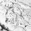
Photographs and Off-line Digital Images |
D 59393 |
RCAHMS Aerial Photography |
Oblique aerial view of the remains of the farmsteads, taken from the S. |
12/2/2001 |
Item Level |
|
 |
On-line Digital Images |
DP 086804 |
RCAHMS Aerial Photography Digital |
Oblique aerial view of the farmsteads and field boundaries, looking NNW. |
2/3/2010 |
Item Level |
|
 |
On-line Digital Images |
DP 086806 |
RCAHMS Aerial Photography Digital |
Oblique aerial view of the farmsteads and field boundaries, looking NW. |
2/3/2010 |
Item Level |
|
 |
On-line Digital Images |
DP 086808 |
RCAHMS Aerial Photography Digital |
Oblique aerial view of the farmsteads and field boundaries, looking WSW. |
2/3/2010 |
Item Level |
|
 |
On-line Digital Images |
SC 1702525 |
RCAHMS Aerial Photography |
Oblique aerial view of the remains of the farmsteads and field banks, taken from the NW. |
12/2/2001 |
Item Level |
|
 |
On-line Digital Images |
SC 1702526 |
RCAHMS Aerial Photography |
Oblique aerial view of the remains of the farmsteads and field banks, taken from the NW. |
12/2/2001 |
Item Level |
|
 |
On-line Digital Images |
SC 1702527 |
RCAHMS Aerial Photography |
Oblique aerial view of the remains of the farmsteads and field banks, taken from the W. |
12/2/2001 |
Item Level |
|
 |
On-line Digital Images |
SC 1702528 |
RCAHMS Aerial Photography |
Oblique aerial view of the remains of the farmsteads and field banks, taken from the WSW. |
12/2/2001 |
Item Level |
|
 |
On-line Digital Images |
SC 1702529 |
RCAHMS Aerial Photography |
Oblique aerial view of the remains of the farmsteads, taken from the S. |
12/2/2001 |
Item Level |
|
 |
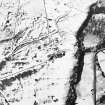
On-line Digital Images |
SC 2390648 |
Records of the Ordnance Survey, Southampton, Hampshire, England |
Brae Of Murthly, NN84NE 41, Ordnance Survey index card, Recto |
c. 1958 |
Item Level |
|
 |
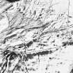
On-line Digital Images |
SC 2390649 |
Records of the Ordnance Survey, Southampton, Hampshire, England |
Brae Of Murthly, NN84NE 41, Ordnance Survey index card, Recto |
c. 1958 |
Item Level |
|


