Accessibility

Font Size

100% 150% 200%

Background Colour

Default Contrast
Close Reset

Pitlessie, 4 Cupar Road, Priestfield Maltings

Brewery (Period Unassigned)

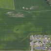
Site Name Pitlessie, 4 Cupar Road, Priestfield Maltings

Classification Brewery (Period Unassigned)

Alternative Name(s) Bonthrone Maltings

Canmore ID 256024

Site Number NO30NW 30.01

NGR NO 33703 09647

Datum OSGB36 - NGR

Permalink http://canmore.org.uk/site/256024

Ordnance Survey licence number AC0000807262. All rights reserved.
Canmore Disclaimer. © Bluesky International Limited 2025. Public Sector Viewing Terms

Toggle Aerial | View on large map

Digital Images

Aerial photograph of field showing maltings
Aerial photograph of field showing maltingsOblique aerial view.Oblique aerial view.View from SouthView from North EastInterior, from North West, along bottom of central and North kilns, showing firebox doors and sheet metal sides beneath kilnCast iron column, first floor of maltings (0.17m diameter at base), situated in centre of range between 2nd and 3rd baysWooden hopper and bucket elevators, South corner, first floor of maltingsPitlessie, Cupar Road, Priestfield Maltings
General ViewPitlessie, Cupar Road, Priestfield Maltings
View of kilnsOblique aerial view.Oblique aerial view.View from North WestDetail of replacement kiln ventilator (Maggie) on centre kilnInterior detail, first floor windowCast iron columns (0.20m diameter at base) beneath storage bin at South West end of rangeOblique aerial view centred on the cropmarks of the possible henge, possible barrow and rig with the brewery adjacent, taken from the WSW.Oblique aerial view centred on the cropmarks of the possible henge, possible barrow and rig with the brewery adjacent, taken from the E.View from NEInterior detail of middle kiln floor and fanSack filling and weighing machine beneath storage bins at South West end of range (made by Avery of Birmingham)Oblique aerial view centred on the cropmarks of the possible henge, possible barrow and rig with the brewery adjacent, taken from the S.Detail of water tank (former egg end boiler) at East end of maltings range, from EastInterior detail, top floor windowFirebox doors, South kilnPitlessie, Cupar Road, Priestfield Maltings
General ViewView from South WestDetail of elevator tower and sheet metal revolving ventilatorCast iron column, top floor of maltingsOblique aerial view centred on the cropmarks of the possible henge, possible barrow and rig with the brewery adjacent, taken from the W.Detail of original kiln ventilator (Maggie) on South kiln from EastFirst floor of maltings, interior from South WestPitlessie, Priestfield Maltings
View of kilns and N facing frontage, from NWGeneral oblique aerial view centred on the cropmarks of the possible henge, possible barrow and rig with the brewery and village adjacent, taken from the NNW.Firebox doors, middle kilnCast iron wall plate, first floor level of maltings, North West side of buildingPitlessie, Priestfield Maltings
View of N frontage of buildings from NE, kilns in right backgroundPitlessie, Cupar Road, Priestfield Maltings
General ViewPitlessie, Cupar Road, Priestfield Maltings
General ViewAerial photograph of field with maltingsAerial photograph of field showing maltingsDouble kiln door floor (combined and North kilns) interior from North showing steel mesh floor, partly obscured by pigeon droppingsCast iron column, first floor of maltings (0.17m diamater at base) situated between 1st and 2nd baysSteeping tank, North East end, first floor maltings (1.0m high and 1.98m wide)

Administrative Areas

  • Council Fife
  • Parish Cults
  • Former Region Fife
  • Former District North East Fife
  • Former County Fife

Archaeology Notes

NO30NW 191 33703 09647

A three-storey, two by eleven bay rubble structure with threecombined kilns and malt stores at the W end.

J R Hume 1977

Architecture Notes

NO30NW 191 33703 09647

Now converted into residential flats.

References

MyCanmore Image Contributions


Contribute an Image

MyCanmore Text Contributions