
Aberfeldy, Taybridge Road, Tay Bridge


Road Bridge (18th Century)
Site Name Aberfeldy, Taybridge Road, Tay Bridge
Classification Road Bridge (18th Century)
Alternative Name(s) General Wade's Bridge; River Tay; Aberfeldy Bridge
Canmore ID 25601
Site Number NN84NE 36
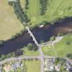
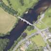
NGR NN 85134 49298
Datum OSGB36 - NGR
Permalink http://canmore.org.uk/site/25601


- Council Perth And Kinross
- Parish Weem
- Former Region Tayside
- Former District Perth And Kinross
- Former County Perthshire
NN84NE 36 85134 49298
Tay Bridge [NAT]
OS 1:10,000 map, 1977.
NMRS REFERENCE:
Architect: William Adam, 1733.
EXTERNAL REFERENCE:
SCOTTISH RECORD OFFICE
Obelisks for the Wade Bridge. 'Thomas Winter is not yet come to the place (Aberuthven) being General Wade has ordered some obelisks to be set over the great pillars of the Bridge of Tay, which Thomas is now about finishing off.'
Letter William Adam to Mungo Graham of Gorthie, 1734.
GD 220/5/1318/3.
(Undated) information in NMRS.
Forming part of the Stirling - Inverness military road (NN84NE 46, MR 3).
M Ferguson 1891.
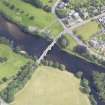
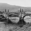
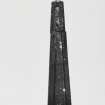
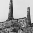
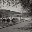
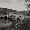
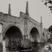
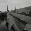
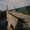
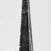
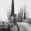
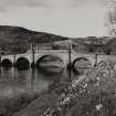
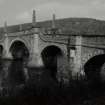
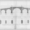
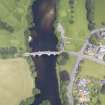
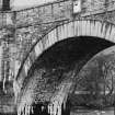
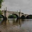
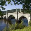
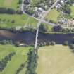
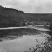
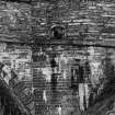
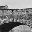
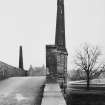
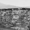
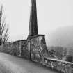
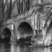
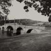
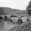
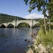
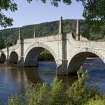
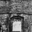
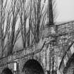
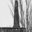
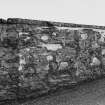
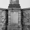
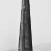
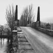
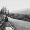
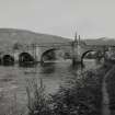
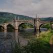
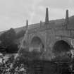
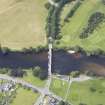
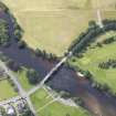
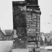
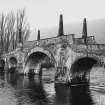
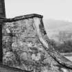
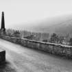
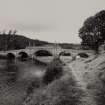
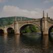
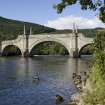
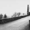
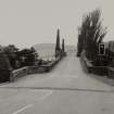
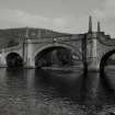
(Location cited as NN 852 493). Aberfeldy, Wade Bridge. Built 1733, the first stone being laid on 23 April, architect William Adam, to the order of Lt-Gen. G Wade. A five-span bridge more than 300 ft (91.4m) long, constructed of grey chlorite schist and with dressed-stone arch rings and rubble spandrels. The starlings are made of oak and the piles beneath the piers and landbreasts are shod with iron. The centre arch is appreciably longer than the other four, and has a raised parapet with four obelisks. The arches are segmental and the cutwaters triangular. The finest bridge, architecturally, on the Scottish military-road system.
J B Salmond 1938; J R Hume 1977.
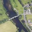
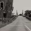
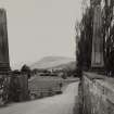
This bridge carries the B846 public road across the River Tay on the NW outskirts of Aberfeldy village (NN84NE 35). This road formerly formed part of the military road MR 3 (LIN 501), and the river here forms the boundary between the parishes of Weem (to the W) and Dull (to the E).
The location assigned to this record indicates the midpoint of the structure. The available map evidence indicates that it extends from NN c. 85100 49306 to NN c. 85168 49290.
Information from RCAHMS (RJCM), 25 May 2006.
Construction (1733 - 1734)
Photographic Survey (1900 - 1930)
Photographs by A Brown & Co of sites across Scotland c1900-1930
Photographic Survey (April 1961)
Photographic survey by the Scottish National Buildings Record in April 1961.
Publication Account (1987)
General Wade was responsible for some 402km of scientifIcally planned roads in the Highlands. They were constructed between 1726 and 1735 and included forty stone bridges, the best known being Aberfeldy Bridge (also known as Tay Bridge), built in 1733. At the time ofits construction it was the only bridge spanning the River Tay, earlier bridges at Dunkeld and Perth having been destroyed.
The five-arched bridge is 112m long and 4.5m wide. It is hump-backed and still in use. The large central arch and stone obelisks at the ends of the level portion of the parapet give it a distinctive appearance.
The designer was William Adam, described by Wade as 'the best Architect in Scotland'. The stone was a chlorite schist from a quarry between Aberfeldy and Kenmore. It took two years to prepare the stones for its construction. At the quarry they were marked and numbered prior to being transported to the site of the bridge. The erection of the bridge was completed in a single year, the piers being supported on timber piles driven into the river-bed.
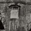
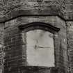
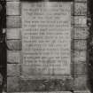
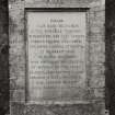
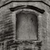
There are two inscriptions engraved in the parapet The fIrst in English reads:
'At the command of His Majesty King George
the 2nd this bridge was erected in the year 1733:
this with the roads and other military works for
securing a safe and easy communication
between the high lands and the tradeing towns
of the low country was by His Majesty
committed to the care of General George Wade,
Commander-in-Chief of the Forces in Scotland
who laid the fIrst stone of this bridge on 23rd
April and fmished the work in the same year.'
The other inscription is in Latin and has been translated as:
'Admire this military road stretching on this
side and that 250 miles beyond the limits of the
Roman one, mocking moors and bogs, opened
up through rocks and over mountains, and, as
you see, crossing the indignant Tay. This
diffIcult work G. Wade, Commander-in-Chief of
the Forces in Scotland, accomplished by his own
skill and ten years labour of his soldiers in the
year of the Christian Era, 1733. Behold how
much avail the Royal auspices of George 2nd.'
Project (2007)
This project was undertaken to input site information listed in 'Civil engineering heritage: Scotland - Lowlands and Borders' by R Paxton and J Shipway, 2007.
Publication Account (2007)
This five-arch bridge, now carrying the B846 road over the Tay, was built in 1733–34 as part of a system of military roads in Scotland amounting to about 250 miles. It is the most ‘architectural’ of 40 bridges planned and laid out under General Wade’s direction from ca.1725. Although generally known as ‘Wade’s Bridge’ it was designed by William Adam and built of a grey-green chlorite schist from nearby Farrockhill quarry.
The nearly semicircular arches are of 30 ft, 35 ft, 60 ft, 35 ft and 30 ft span and the roadway is 14 ft wide. The bridge is carried on some 1200 timber piles shod with iron. It is said that the stones were prepared and numbered at the quarry before being sent to site and that the cost of the bridge was £4095. The timber centring of the main arch may have been struck too early as there is a sag of about 3 in. in the parapet. A small dam downstream of the bridge reduces scour to the bridge foundations.
The bridge is ornamented and elegant as befits the work of Adam but Southey, perhaps reflecting Telford’s view on their visit in 1819, wrote, ‘At a distance it looks well, but makes a wretched appearance upon close inspection. There are four unmeaning obelisks upon the central arch, and the parapet is so high that you cannot see over it.’ The roadway surface may have been raised later as the parapet comment now only applies locally at its upward sweeps or ‘juts’.
R Paxton and J Shipway
Reproduced from 'Civil Engineering heritage: Scotland - Lowlands and Borders' with kind permission of Thomas Telford Publishers.

