
Broich


Palisaded Enclosure(S) (Prehistoric)(Possible)
Site Name Broich
Classification Palisaded Enclosure(S) (Prehistoric)(Possible)
Alternative Name(s) Duchlage; Broich Road Farm
Canmore ID 25493
Site Number NN82SE 68
NGR NN 8673 2018
Datum OSGB36 - NGR
Permalink http://canmore.org.uk/site/25493


- Council Perth And Kinross
- Parish Crieff
- Former Region Tayside
- Former District Perth And Kinross
- Former County Perthshire
NN82SE 68 8673 2018.
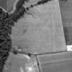
Oblique aerial photography (RCAHMSAP 1996) has recorded the partial destruction of both of these palisaded enclosures by the extension of the nearby North Forr landfill site. The extension stops just short of the cursus monument recorded as intersecting these enclosures (NN82SE 69).
Information from RCAHMS (KB) 2 March 2000
There are no further plans to extend the landfill site.
Information contained in a letter from A D P Burke, Historic Scotland, 11 February 1999.
Scheduled with NN82SE 69 as Broich, cursus, ring-ditch, barrow and palisade.
Information from Historic Scotland, scheduling document dated 8 November 2000.
Aerial Photographic Transcription (11 August 1997 - 12 August 1997)
An aerial transcription was produced from oblique aerial photographs. Information from Historic Environment Scotland (BM) 31 March 2017.
Field Visit (27 March 1997)
NN82SE 68 8673 2018.
There are two palisaded enclosures, probably settlements, revealed as cropmarks by aerial photography (RCAHMSAP 1992) on the leading edge of the terrace on the N bank of the River Earn. The lines of the palisade trenches of both enclosures intersect the eastern ditch of a cursus (NN82SE 69), and each other, but the relative sequence of construction is not clear. The larger of the enclosures (EARNAP 148) is sub-circular and measures about 94m in diameter. The perimeter is somewhat intermittent on the W, and there is a gap, possibly an entrance, on the N. A dark mark on the photograph at the centre of the enclosure is probably geological in origin. The second enclosure is visible as little more than an arc of a palisade trench, measuring at most about 38m along the chord.
(EARNAP 147, 148)
Visited by RCAHMS (DCC) 27 March 1997
Aerial Photographic Transcription (11 January 2019)
An interpretative transcription, or mapping, of information on oblique aerial photographs was produced on 11 January 2019.

