
Pricing Change
New pricing for orders of material from this site will come into place shortly. Charges for supply of digital images, digitisation on demand, prints and licensing will be altered.
Rottal


Clearance Cairn(S) (Period Unknown), Farmstead (Post Medieval), Kiln (Post Medieval)(Possible), Potato Pit(S) (Post Medieval), Rig And Furrow (Medieval) - (Post Medieval)
Site Name Rottal
Classification Clearance Cairn(S) (Period Unknown), Farmstead (Post Medieval), Kiln (Post Medieval)(Possible), Potato Pit(S) (Post Medieval), Rig And Furrow (Medieval) - (Post Medieval)
Alternative Name(s) Balloch
Canmore ID 254868
Site Number NO37SE 27
NGR NO 36807 70095
Datum OSGB36 - NGR
Permalink http://canmore.org.uk/site/254868


- Council Angus
- Parish Cortachy And Clova
- Former Region Tayside
- Former District Angus
- Former County Angus
Field Visit (25 March 1999)
NO37SE 27 36807 70095
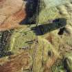
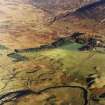
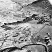
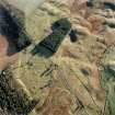
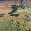
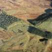
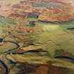
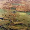
This farmstead, which comprises the robbed remains of nine buildings, is situated in unimproved pasture on the floodplain of the River South Esk, some 450m NW of Rottal. Six of the buildings (CLOVA99 475-8) are disposed around three sides of a yard that is open to the SSW, the seventh (CLOVA99 479) lies 25m to the NNW, the eighth (CLOVA99 421) is situated 70m to the W, and the ninth (CLOVA99 481) lies 90m N. A possible kiln is situated close to the SE corner of the yard and an arcing line of six potato clamps lies 25m to the SW of the main cluster of buildings.
The largest building (CLOVA99 478) lies on the NNE side of the yard and measures 19.9m from NW to SE by 3.8m in breadth within rubble walls 0.6m in thickness and 0.4m in height. It has two compartments and there is an entrance in the SW side; an outshot is attached to the SE end. This building is depicted as roofed on the 1st edition of the OS 6-inch map (Forfarshire 1865, sheet xvii), when the farm bore the name Balloch. This map also depicts a small field immediately to the N of this building, which contains traces of rig-and-furrow, and the enclosure immediately E.
The other buildings in the farmstead range in size from 4.9m to 11.9m in length by between 2.3m and 3.8m in breadth within walls that stand no more than 0.3m in height. Two of these buildings (CLOVA99 421 & 477) have two compartments, while three others (CLOVA99 479-81) have outshots attached. A group of at least twelve clearance cairns is disposed around the northernmost building (CLOVA99 480), while nine further cairns are visible around the westernmost building (CLOVA99 421).
(CLOVA99 421, 475-480)
Visited by RCAHMS (DCC) 25 March 1999

