
Wheen


Building (Post Medieval), Rig And Furrow (Medieval) - (Post Medieval)
Site Name Wheen
Classification Building (Post Medieval), Rig And Furrow (Medieval) - (Post Medieval)
Canmore ID 254389
Site Number NO37SE 16
NGR NO 36114 70325
Datum OSGB36 - NGR
Permalink http://canmore.org.uk/site/254389


- Council Angus
- Parish Cortachy And Clova
- Former Region Tayside
- Former District Angus
- Former County Angus
Field Visit (5 October 1998)
NO37SE 16 36114 70325
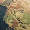
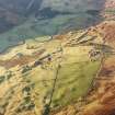
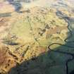
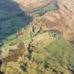
This building is situated in a natural hollow at the NE edge of the floodplain of the River South Esk, some 600m S of Wheen. Rectangular on plan, it measures 11.9m from NW to SE by 1.7m transversely within rubble walls 0.6m in thickness and 0.4m in height. It has an entrance on the SW side and a possible yard to the NE. The building overlies an area of plough-levelled rig-and-furrow cultivation.
(CLOVA99 18)
Visited by RCAHMS (DCC) 5 October 1998

