
Pricing Change
New pricing for orders of material from this site will come into place shortly. Charges for supply of digital images, digitisation on demand, prints and licensing will be altered.
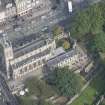
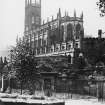
Edinburgh, Princes Street, St John's Episcopal Church, Churchyard


Churchyard (19th Century)
Site Name Edinburgh, Princes Street, St John's Episcopal Church, Churchyard
Classification Churchyard (19th Century)
Canmore ID 254325
Site Number NT27SW 184.01
NGR NT 24810 73667
Datum OSGB36 - NGR
Permalink http://canmore.org.uk/site/254325


- Council Edinburgh, City Of
- Parish Edinburgh (Edinburgh, City Of)
- Former Region Lothian
- Former District City Of Edinburgh
- Former County Midlothian
NT27SW 184.01 24810 73667
INVENTORY OF GRAVEYARD AND CEMETERY SITES IN SCOTLAND REFERENCE:
Address: St. John's Episcopal Church Churchyard, Lothian Road, Edinburgh
Postcode: EH1 2EP, EH2 4BJ
Status: Closed for burials but maintained
Size: 0.05 hectares, 1.24 acres
Polygon: No
TOIDs:
Number of gravestones: Not known
Earliest burial: 1818
Most recent burial: 1965
Description: Burial ground associated with a church. Only graveyard in Edinburgh maintained by an Episcopal church.
Data Sources: OS MasterMap checked 14 September 2005; www.stjohns-edinburgh.org.uk checked 14 September 2005
Archaeological Evaluation (29 April 2008)
NT 24810 73660 An evaluation consisting of peat probing and test pitting to a depth of 0.3m was undertaken in the churchyard on 29 April 2008. The work aimed to establish the depth and condition of any buried recumbent monuments and stub walls. Results indicate that virtually all plot walls present on the 1853 OS plan of the graveyard survive below ground level. Two buried recumbent monuments were also located.
Archive: RCAHMS
Funder: Peter McGowan Associates
Edward Bailey (Headland Archaeology Ltd), 2008
Ground Penetrating Radar (10 November 2009 - 11 November 2009)
NT 251 734 A ground penetrating radar survey of the graveyard at the St John the Evangelist Church was carried out 10–11 November 2009. Several collapses had taken place in the graveyard in during the previous year and the survey aimed to locate areas of possible future collapse. The survey identified several areas of potential subsidence and recumbent stone vault markers that may be at risk of collapse.
Archive: RCAHMS (intended)
Funder: Vestry of St John the Evangelist/John Renshaw Architect
Donna M Maguire – GUARD

