
Stirling,14-20 Pitt Terrace, New Viewforth


Local Government Office (20th Century)
Site Name Stirling,14-20 Pitt Terrace, New Viewforth
Classification Local Government Office (20th Century)
Alternative Name(s) Viewforth Central Region Headquarters
Canmore ID 254109
Site Number NS79SE 704
NGR NS 79629 92749
Datum OSGB36 - NGR
Permalink http://canmore.org.uk/site/254109
Ordnance Survey licence number AC0000807262. All rights reserved.
Canmore Disclaimer.
© Bluesky International Limited 2025. Public Sector Viewing Terms
- Correction
- Favourite

DP 155200
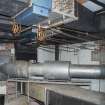
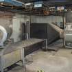
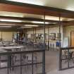
Interior. General view of original air conditioning system in basement room B25.
Records of the Royal Commission on the Ancient and Historical Monuments of Scotland (RCAHMS), Edinbu
22/5/2013
© Crown Copyright: HES

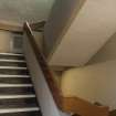
DP 155207
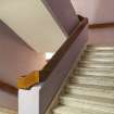
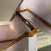
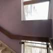
Interior. General view of main staircase.
Records of the Royal Commission on the Ancient and Historical Monuments of Scotland (RCAHMS), Edinbu
22/5/2013
© Crown Copyright: HES

DP 155212
Interior. General view of fire stairs on east wing.
Records of the Royal Commission on the Ancient and Historical Monuments of Scotland (RCAHMS), Edinbu
22/5/2013
© Crown Copyright: HES

DP 155217
Interior. General view of landing/stairhall area on the third floor.
Records of the Royal Commission on the Ancient and Historical Monuments of Scotland (RCAHMS), Edinbu
22/5/2013
© Crown Copyright: HES

DP 155220
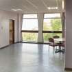
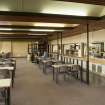
Interior. General view of Architects office in South wing.
Records of the Royal Commission on the Ancient and Historical Monuments of Scotland (RCAHMS), Edinbu
22/5/2013
© Crown Copyright: HES

DP 155222
Interior. General view of Architects office in South wing.
Records of the Royal Commission on the Ancient and Historical Monuments of Scotland (RCAHMS), Edinbu
22/5/2013
© Crown Copyright: HES

DP 155226
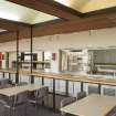
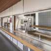
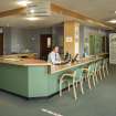
Interior. General view of Restaurant showing serving counter.
Records of the Royal Commission on the Ancient and Historical Monuments of Scotland (RCAHMS), Edinbu
22/5/2013
© Crown Copyright: HES

DP 155228
Interior. General view of Restaurant.
Records of the Royal Commission on the Ancient and Historical Monuments of Scotland (RCAHMS), Edinbu
22/5/2013
© Crown Copyright: HES

DP 155239
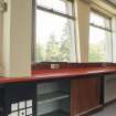
Interior. Detail of underwindow workbench and storage.
Records of the Royal Commission on the Ancient and Historical Monuments of Scotland (RCAHMS), Edinbu
22/5/2013
© Crown Copyright: HES

DP 155257
General view of East wing from South East.
Records of the Royal Commission on the Ancient and Historical Monuments of Scotland (RCAHMS), Edinbu
22/5/2013
© Crown Copyright: HES

DP 155259
General view from North West.
Records of the Royal Commission on the Ancient and Historical Monuments of Scotland (RCAHMS), Edinbu
22/5/2013
© Crown Copyright: HES

DP 155260
Detail of cladding from West looking allong South face of West wing.
Records of the Royal Commission on the Ancient and Historical Monuments of Scotland (RCAHMS), Edinbu
22/5/2013
© Crown Copyright: HES

SC 1390358
View from SSE.
Records of the Royal Commission on the Ancient and Historical Monuments of Scotland (RCAHMS), Edinbu
13/2/2002
© Crown Copyright: HES

DP 176030
Oblique aerial view of the Viewforth Local Government Offices, Stirling, during demolition, looking ESE.
RCAHMS Aerial Photography Digital
7/2/2014
© Crown Copyright: HES

DP 176033
Oblique aerial view of the Viewforth Local Government Offices, Stirling, during demolition, looking NNW.
RCAHMS Aerial Photography Digital
7/2/2014
© Crown Copyright: HES

DP 155185
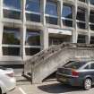
General view from South of entrance on west wing.
Records of the Royal Commission on the Ancient and Historical Monuments of Scotland (RCAHMS), Edinbu
22/5/2013
© Crown Copyright: HES

DP 155229
Interior. General view of serving counters.
Records of the Royal Commission on the Ancient and Historical Monuments of Scotland (RCAHMS), Edinbu
22/5/2013
© Crown Copyright: HES

DP 155232
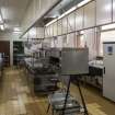
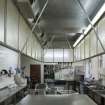
Interior. General view of Kitchen from South.
Records of the Royal Commission on the Ancient and Historical Monuments of Scotland (RCAHMS), Edinbu
22/5/2013
© Crown Copyright: HES

DP 155240
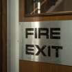
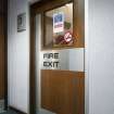
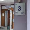
Interior. Detail of signage on Fire door.
Records of the Royal Commission on the Ancient and Historical Monuments of Scotland (RCAHMS), Edinbu
22/5/2013
© Crown Copyright: HES

DP 155241
Interior. Detail of signage on Restaurant entrance.
Records of the Royal Commission on the Ancient and Historical Monuments of Scotland (RCAHMS), Edinbu
22/5/2013
© Crown Copyright: HES

DP 155242
Interior. General view of Fire exit door.
Records of the Royal Commission on the Ancient and Historical Monuments of Scotland (RCAHMS), Edinbu
22/5/2013
© Crown Copyright: HES

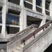
DP 155255
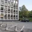
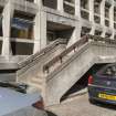
General view of car park and South wing from North West.
Records of the Royal Commission on the Ancient and Historical Monuments of Scotland (RCAHMS), Edinbu
22/5/2013
© Crown Copyright: HES

SC 1390357
View from S.
Records of the Royal Commission on the Ancient and Historical Monuments of Scotland (RCAHMS), Edinbu
13/2/2002
© Crown Copyright: HES

SC 2497124
View from W.
Records of the Royal Commission on the Ancient and Historical Monuments of Scotland (RCAHMS), Edinbu
13/2/2002
© Crown Copyright: HES

SC 2497125
View from W.
Records of the Royal Commission on the Ancient and Historical Monuments of Scotland (RCAHMS), Edinbu
13/2/2002
© Crown Copyright: HES

DP 155201
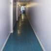
Interior. General view of Basement corridor with lino floor.
Records of the Royal Commission on the Ancient and Historical Monuments of Scotland (RCAHMS), Edinbu
22/5/2013
© Crown Copyright: HES

DP 155208
Interior. General view of main staircase.
Records of the Royal Commission on the Ancient and Historical Monuments of Scotland (RCAHMS), Edinbu
22/5/2013
© Crown Copyright: HES

DP 155216
Interior. HDR Photo. General view of stair and window configuration on third floor.
Records of the Royal Commission on the Ancient and Historical Monuments of Scotland (RCAHMS), Edinbu
22/5/2013
© Crown Copyright: HES

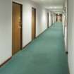
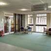
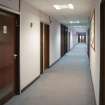
DP 155219
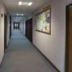
Interior. General view looking West of corridor in West wing.
Records of the Royal Commission on the Ancient and Historical Monuments of Scotland (RCAHMS), Edinbu
22/5/2013
© Crown Copyright: HES

DP 155223
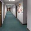
Interior. General view of corridor in North wing leading to the Restaurant.
Records of the Royal Commission on the Ancient and Historical Monuments of Scotland (RCAHMS), Edinbu
22/5/2013
© Crown Copyright: HES

DP 155238
Interior. HDR Photo. General view of Coffee shop from South.
Records of the Royal Commission on the Ancient and Historical Monuments of Scotland (RCAHMS), Edinbu
22/5/2013
© Crown Copyright: HES

DP 155243
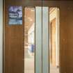
Interior. General view of Restaurant door showing signage.
Records of the Royal Commission on the Ancient and Historical Monuments of Scotland (RCAHMS), Edinbu
22/5/2013
© Crown Copyright: HES

DP 155245
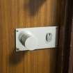
Interior. Detail of door furniture.
Records of the Royal Commission on the Ancient and Historical Monuments of Scotland (RCAHMS), Edinbu
22/5/2013
© Crown Copyright: HES

DP 155249
General view from North of West face of North wing..
Records of the Royal Commission on the Ancient and Historical Monuments of Scotland (RCAHMS), Edinbu
22/5/2013
© Crown Copyright: HES

DP 155254
General view from South West of entrance on West wing.
Records of the Royal Commission on the Ancient and Historical Monuments of Scotland (RCAHMS), Edinbu
22/5/2013
© Crown Copyright: HES

DP 155258
General view of North wing from North.
Records of the Royal Commission on the Ancient and Historical Monuments of Scotland (RCAHMS), Edinbu
22/5/2013
© Crown Copyright: HES

SC 1390354
View from W.
Records of the Royal Commission on the Ancient and Historical Monuments of Scotland (RCAHMS), Edinbu
13/2/2002
© Crown Copyright: HES

SC 2497119
View from SSE.
Records of the Royal Commission on the Ancient and Historical Monuments of Scotland (RCAHMS), Edinbu
13/2/2002
© Crown Copyright: HES

DP 155186
General view from South of West wing.
Records of the Royal Commission on the Ancient and Historical Monuments of Scotland (RCAHMS), Edinbu
22/5/2013
© Crown Copyright: HES

DP 155189
General view from East of rear entrance on North Wing.
Records of the Royal Commission on the Ancient and Historical Monuments of Scotland (RCAHMS), Edinbu
22/5/2013
© Crown Copyright: HES

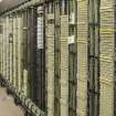
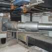
DP 155198
Interior. General view of original air conditioning system in basement room B25.
Records of the Royal Commission on the Ancient and Historical Monuments of Scotland (RCAHMS), Edinbu
22/5/2013
© Crown Copyright: HES

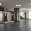
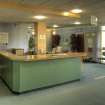
DP 155204
Interior. General view of reception area.
Records of the Royal Commission on the Ancient and Historical Monuments of Scotland (RCAHMS), Edinbu
22/5/2013
© Crown Copyright: HES

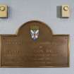
DP 155205
Interior. Detail of wall plaque commemorating the opening of the extension to the building on 29th Feb 1972.
Records of the Royal Commission on the Ancient and Historical Monuments of Scotland (RCAHMS), Edinbu
22/5/2013
© Crown Copyright: HES

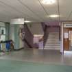
DP 155209
Interior. General view of open stairhall area on first floor.
Records of the Royal Commission on the Ancient and Historical Monuments of Scotland (RCAHMS), Edinbu
22/5/2013
© Crown Copyright: HES

DP 155221
Interior. General view of Architects office in South wing.
Records of the Royal Commission on the Ancient and Historical Monuments of Scotland (RCAHMS), Edinbu
22/5/2013
© Crown Copyright: HES

DP 155224
Interior. General view of corridor in North wing leading to the Restaurant.
Records of the Royal Commission on the Ancient and Historical Monuments of Scotland (RCAHMS), Edinbu
22/5/2013
© Crown Copyright: HES

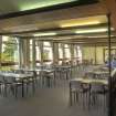
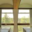
DP 155227
Interior. HDR Photo. General view of Restaurant showing windows and vaulted celing.
Records of the Royal Commission on the Ancient and Historical Monuments of Scotland (RCAHMS), Edinbu
22/5/2013
© Crown Copyright: HES

DP 155237
Interior. General view of Coffee shop from North West.
Records of the Royal Commission on the Ancient and Historical Monuments of Scotland (RCAHMS), Edinbu
22/5/2013
© Crown Copyright: HES

DP 155256
General view of entrance on Soth face of South wing.
Records of the Royal Commission on the Ancient and Historical Monuments of Scotland (RCAHMS), Edinbu
22/5/2013
© Crown Copyright: HES

SC 2497113
View from W.
Records of the Royal Commission on the Ancient and Historical Monuments of Scotland (RCAHMS), Edinbu
13/2/2002
© Crown Copyright: HES

SC 2497115
View from SSW.
Records of the Royal Commission on the Ancient and Historical Monuments of Scotland (RCAHMS), Edinbu
13/2/2002
© Crown Copyright: HES

SC 2497121
View from E.
Records of the Royal Commission on the Ancient and Historical Monuments of Scotland (RCAHMS), Edinbu
13/2/2002
© Crown Copyright: HES

DP 155194
General view from South showing Langarth to the right.
Records of the Royal Commission on the Ancient and Historical Monuments of Scotland (RCAHMS), Edinbu
22/5/2013
© Crown Copyright: HES

DP 155195
General view from West of North wing.
Records of the Royal Commission on the Ancient and Historical Monuments of Scotland (RCAHMS), Edinbu
22/5/2013
© Crown Copyright: HES

DP 155196
Interior. General view of original telephone system in basement room B04.
Records of the Royal Commission on the Ancient and Historical Monuments of Scotland (RCAHMS), Edinbu
22/5/2013
© Crown Copyright: HES

DP 155202
Interior. HDR Photo. General view of reception area.
Records of the Royal Commission on the Ancient and Historical Monuments of Scotland (RCAHMS), Edinbu
22/5/2013
© Crown Copyright: HES

DP 155213
Interior. General view of open stairhall area on second floor.
Records of the Royal Commission on the Ancient and Historical Monuments of Scotland (RCAHMS), Edinbu
22/5/2013
© Crown Copyright: HES

DP 155214
Interior. General view of open stairhall area on second floor.
Records of the Royal Commission on the Ancient and Historical Monuments of Scotland (RCAHMS), Edinbu
22/5/2013
© Crown Copyright: HES

DP 155218
Interior. General view looking West of corridor in West wing.
Records of the Royal Commission on the Ancient and Historical Monuments of Scotland (RCAHMS), Edinbu
22/5/2013
© Crown Copyright: HES

DP 155230
Interior. HDR Photo. Detail of windows and vaulted celing in Restaurant.
Records of the Royal Commission on the Ancient and Historical Monuments of Scotland (RCAHMS), Edinbu
22/5/2013
© Crown Copyright: HES

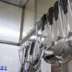
DP 155234
Interior. Detail of utensils hanging on extractor hood.
Records of the Royal Commission on the Ancient and Historical Monuments of Scotland (RCAHMS), Edinbu
22/5/2013
© Crown Copyright: HES

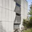
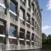
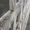
DP 155262
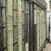
Detail of cladding on South wing.
Records of the Royal Commission on the Ancient and Historical Monuments of Scotland (RCAHMS), Edinbu
22/5/2013
© Crown Copyright: HES

DP 155264
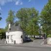
General view of Gate Lodge with South Wing behind.
Records of the Royal Commission on the Ancient and Historical Monuments of Scotland (RCAHMS), Edinbu
22/5/2013
© Crown Copyright: HES

DP 155265
General view from South East at Langgarth.
Records of the Royal Commission on the Ancient and Historical Monuments of Scotland (RCAHMS), Edinbu
22/5/2013
© Crown Copyright: HES

SC 1390359
View from SE.
Records of the Royal Commission on the Ancient and Historical Monuments of Scotland (RCAHMS), Edinbu
13/2/2002
© Crown Copyright: HES

SC 1390360
View from E.
Records of the Royal Commission on the Ancient and Historical Monuments of Scotland (RCAHMS), Edinbu
13/2/2002
© Crown Copyright: HES

SC 1390361
View from E.
Records of the Royal Commission on the Ancient and Historical Monuments of Scotland (RCAHMS), Edinbu
13/2/2002
© Crown Copyright: HES

SC 1390362
View from W.
Records of the Royal Commission on the Ancient and Historical Monuments of Scotland (RCAHMS), Edinbu
13/2/2002
© Crown Copyright: HES

DP 176031
Oblique aerial view of the Viewforth Local Government Offices, Stirling, during demolition, looking ENE.
RCAHMS Aerial Photography Digital
7/2/2014
© Crown Copyright: HES

SC 2497117
View from S.
Records of the Royal Commission on the Ancient and Historical Monuments of Scotland (RCAHMS), Edinbu
13/2/2002
© Crown Copyright: HES

SC 2497118
View from S.
Records of the Royal Commission on the Ancient and Historical Monuments of Scotland (RCAHMS), Edinbu
13/2/2002
© Crown Copyright: HES

SC 2497122
View from E.
Records of the Royal Commission on the Ancient and Historical Monuments of Scotland (RCAHMS), Edinbu
13/2/2002
© Crown Copyright: HES

SC 2497123
View from E.
Records of the Royal Commission on the Ancient and Historical Monuments of Scotland (RCAHMS), Edinbu
13/2/2002
© Crown Copyright: HES

DP 155190
General view from North East of North wing.
Records of the Royal Commission on the Ancient and Historical Monuments of Scotland (RCAHMS), Edinbu
22/5/2013
© Crown Copyright: HES

DP 155193
General view of North wing from South East.
Records of the Royal Commission on the Ancient and Historical Monuments of Scotland (RCAHMS), Edinbu
22/5/2013
© Crown Copyright: HES

DP 155197
Interior. General view of original telephone system in basement room B04.
Records of the Royal Commission on the Ancient and Historical Monuments of Scotland (RCAHMS), Edinbu
22/5/2013
© Crown Copyright: HES

DP 155199
Interior. General view of original air conditioning system in basement room B25.
Records of the Royal Commission on the Ancient and Historical Monuments of Scotland (RCAHMS), Edinbu
22/5/2013
© Crown Copyright: HES

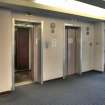
DP 155206
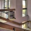
Interior. General view of lifts.
Records of the Royal Commission on the Ancient and Historical Monuments of Scotland (RCAHMS), Edinbu
22/5/2013
© Crown Copyright: HES

DP 155210
Interior. General view of open stairhall area on first floor.
Records of the Royal Commission on the Ancient and Historical Monuments of Scotland (RCAHMS), Edinbu
22/5/2013
© Crown Copyright: HES

DP 155211
Interior. General view of fire stairs on east wing.
Records of the Royal Commission on the Ancient and Historical Monuments of Scotland (RCAHMS), Edinbu
22/5/2013
© Crown Copyright: HES

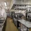
DP 155231
Interior. General view of Kitchen from North.
Records of the Royal Commission on the Ancient and Historical Monuments of Scotland (RCAHMS), Edinbu
22/5/2013
© Crown Copyright: HES

DP 155233
Interior. General view of Kitchen from under the extractor hood.
Records of the Royal Commission on the Ancient and Historical Monuments of Scotland (RCAHMS), Edinbu
22/5/2013
© Crown Copyright: HES

DP 155246
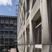
General view of exterior cladding.
Records of the Royal Commission on the Ancient and Historical Monuments of Scotland (RCAHMS), Edinbu
22/5/2013
© Crown Copyright: HES

DP 155251
General view from North West.
Records of the Royal Commission on the Ancient and Historical Monuments of Scotland (RCAHMS), Edinbu
22/5/2013
© Crown Copyright: HES

DP 155252
General view from West of South wing.
Records of the Royal Commission on the Ancient and Historical Monuments of Scotland (RCAHMS), Edinbu
22/5/2013
© Crown Copyright: HES

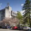
DP 155261
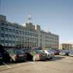
General view of New Viewforth offices, Stirling, from North West of car park and South wing.
Records of the Royal Commission on the Ancient and Historical Monuments of Scotland (RCAHMS), Edinbu
22/5/2013
© Crown Copyright: HES

SC 1390356
View from SSW.
Records of the Royal Commission on the Ancient and Historical Monuments of Scotland (RCAHMS), Edinbu
13/2/2002
© Crown Copyright: HES

SC 2497112
View from W.
Records of the Royal Commission on the Ancient and Historical Monuments of Scotland (RCAHMS), Edinbu
13/2/2002
© Crown Copyright: HES

SC 2497116
View from SSW.
Records of the Royal Commission on the Ancient and Historical Monuments of Scotland (RCAHMS), Edinbu
13/2/2002
© Crown Copyright: HES

DP 155184
General view from west of main entrance.
Records of the Royal Commission on the Ancient and Historical Monuments of Scotland (RCAHMS), Edinbu
22/5/2013
© Crown Copyright: HES

DP 155188
General view from South East of East wing.
Records of the Royal Commission on the Ancient and Historical Monuments of Scotland (RCAHMS), Edinbu
22/5/2013
© Crown Copyright: HES

DP 155191
Detail looking South along East wall of North wing.
Records of the Royal Commission on the Ancient and Historical Monuments of Scotland (RCAHMS), Edinbu
22/5/2013
© Crown Copyright: HES

DP 155203
Interior. General view of reception area.
Records of the Royal Commission on the Ancient and Historical Monuments of Scotland (RCAHMS), Edinbu
22/5/2013
© Crown Copyright: HES

DP 155215
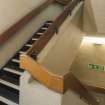
Interior. Detail of window configuration on main stair.
Records of the Royal Commission on the Ancient and Historical Monuments of Scotland (RCAHMS), Edinbu
22/5/2013
© Crown Copyright: HES

DP 155225
Interior. General view of Restaurant from South.
Records of the Royal Commission on the Ancient and Historical Monuments of Scotland (RCAHMS), Edinbu
22/5/2013
© Crown Copyright: HES

DP 155248
Interior. Detail of signage.
Records of the Royal Commission on the Ancient and Historical Monuments of Scotland (RCAHMS), Edinbu
22/5/2013
© Crown Copyright: HES

DP 155250
General view from North West.
Records of the Royal Commission on the Ancient and Historical Monuments of Scotland (RCAHMS), Edinbu
22/5/2013
© Crown Copyright: HES

DP 155253
General view from South West of entrance on West wing.
Records of the Royal Commission on the Ancient and Historical Monuments of Scotland (RCAHMS), Edinbu
22/5/2013
© Crown Copyright: HES

DP 176032
Oblique aerial view of the Viewforth Local Government Offices, Stirling, during demolition, looking NE.
RCAHMS Aerial Photography Digital
7/2/2014
© Crown Copyright: HES

SC 2497120
View from SE.
Records of the Royal Commission on the Ancient and Historical Monuments of Scotland (RCAHMS), Edinbu
13/2/2002
© Crown Copyright: HES


First 100 images shown. See the Collections panel (below) for a link to all digital images.
- Council Stirling
- Parish Stirling
- Former Region Central
- Former District Stirling
- Former County Stirlingshire
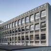
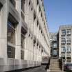
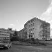
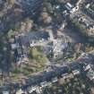
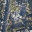
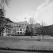
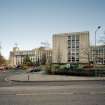
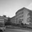
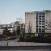
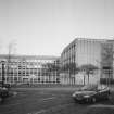
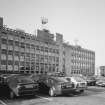
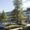
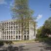
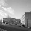
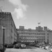
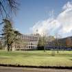
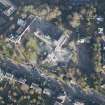
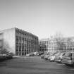
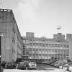
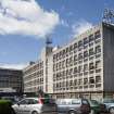
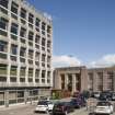
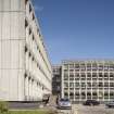
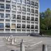
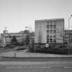
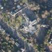
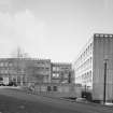
New Viewforth was recorded by RCAHMS Threatened Buildings Survey in June 2013 prior to its proposed demolition. It was designed by A J Smith the Stirling County Architect ad built between 1968 and 1971. The large 5-storey cruciform block is scheduled for demolition in December 2014.
STG 2014
See also NS79SE 483
Field Visit (16 April 2013)
The Stirling Council buildings at New Viewforth were visited by RCAHMS Investigators to assess the buildings for survey. The building is planned to be emptied in Spring/Summer 2013, with demolition following. A photographic survey will be requisitioned prior to works commencing.
Watching Brief (10 June 2013 - 14 June 2013)
AOC Archaeology undertook an archaeological evaluation in respect to a proposed development within the grounds of Stirling Council at Viewforth, St. Ninians Road, Stirling (NGR; NS 7953 9282). The area (3600 m2) was subject to an 8% sample evaluation to comprise 72 linear metres. However the presence of live services and heavy tree canopy reduced the current works to 62 linear metres. The evaluation revealed thirteen pits/post-holes of probable prehistoric date. These features formed a right angled linear alignment and are the possible remains of a substantial post-built structure or enclosure.
Three sherds of late medieval reduced ware pottery were recovered from the interface of the top-soil and natural. These included two body sherds and a skillet handle.
AOC Archaeology Group (R. Engl) OASIS ID: aocarcha1-152783

