
Pricing Change
New pricing for orders of material from this site will come into place shortly. Charges for supply of digital images, digitisation on demand, prints and licensing will be altered.
Upcoming Maintenance
Please be advised that this website will undergo scheduled maintenance on the following dates:
Thursday, 9 January: 11:00 AM - 3:00 PM
Thursday, 23 January: 11:00 AM - 3:00 PM
Thursday, 30 January: 11:00 AM - 3:00 PM
During these times, some functionality such as image purchasing may be temporarily unavailable. We apologise for any inconvenience this may cause.
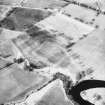
Strageath Mains


Field Boundary(S) (Period Unknown), Pit(S) (Period Unknown), Rig And Furrow (Medieval) - (Post Medieval)
Site Name Strageath Mains
Classification Field Boundary(S) (Period Unknown), Pit(S) (Period Unknown), Rig And Furrow (Medieval) - (Post Medieval)
Canmore ID 25333
Site Number NN81NE 53
NGR NN 8965 1842
Datum OSGB36 - NGR
Permalink http://canmore.org.uk/site/25333


- Council Perth And Kinross
- Parish Muthill
- Former Region Tayside
- Former District Perth And Kinross
- Former County Perthshire
Aerial Photographic Transcription (6 December 1995 - 20 November 1996)
An aerial transcription was produced from oblique aerial photographs. Information from Historic Environment Scotland (BM) 31 March 2017.
Field Visit (26 March 1997)
NN81NE 53 8965 1842
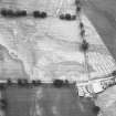
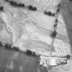
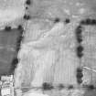
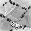
Cropmarks on oblique aerial photographs (C Martin 1981; CUCAP 1984 and RCAHMSAP 1986) reveal a series of ditched field-boundaries, a patch of rig and a scatter of pits on the terrace to the ENE of Strageath Mains. The field-boundaries are marked by straight segments of ditch, mostly running along the leading edge of the terrace and marking the edge of the haughland on the S bank of the River Earn (EARNAP 102). One of the field-boundaries appears to mark the edge of a small block of five furrows spaced about 8m apart (EARNAP 101). Pits, measuring up to 3m across, are visible on the better drained parts of the terrace, many lying in rough rows aligned from N to S (EARNAP 103-6).
(EARNAP 101-6)
Visited by RCAHMS (DCC) 26 March 1997

