
Pricing Change
New pricing for orders of material from this site will come into place shortly. Charges for supply of digital images, digitisation on demand, prints and licensing will be altered.
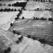
Strageath Cottage


Field System (Period Unknown), Pit(S) (Period Unknown), Sunken Floored Building (Period Unknown)(Possible)
Site Name Strageath Cottage
Classification Field System (Period Unknown), Pit(S) (Period Unknown), Sunken Floored Building (Period Unknown)(Possible)
Canmore ID 25318
Site Number NN81NE 39
NGR NN 8894 1792
Datum OSGB36 - NGR
Permalink http://canmore.org.uk/site/25318


- Council Perth And Kinross
- Parish Muthill
- Former Region Tayside
- Former District Perth And Kinross
- Former County Perthshire
Aerial Photographic Transcription (5 February 1997 - 10 February 1997)
An aerial transcription was produced from oblique aerial photographs. Information from Historic Environment Scotland (BM) 31 March 2017.
Field Visit (26 November 1997)
NN81NE 39 8894 1792
Cropmarks on oblique aerial photographs (RCAHMSAP 1983, 1989, 1992; C Martin 1984) reveal the presence of ditches forming part of a field-layout predating the current field-pattern, but broadly similar in form. The axis of the main boundaries is from ENE to WSW, with two sub-divisions lying at right-angles to them. Two shorter lengths of ditch are also laid out at right-angles to the main axial boundaries. A further ditch, lying at a slight angle to the field-system (NN 8999 1800 to NN 9005 1804), is a covered-over field-drain.
A scatter of pits lie in the angle between two of the field boundaries and are of unknown function, although at least one (NN 8920 1802) is distinctly subrectangular on plan and may be a sunken floored building.
Visited by RCAHMS (DCC) 26 November 1997

