
Dalginross


Quarry Pit(S) (Roman), Temporary Camp (Roman)(Possible)
Site Name Dalginross
Classification Quarry Pit(S) (Roman), Temporary Camp (Roman)(Possible)
Alternative Name(s) Penfillan
Canmore ID 24834
Site Number NN72SE 21
NGR NN 7735 2096
NGR Description Centred NN 7735 2096
Datum OSGB36 - NGR
Permalink http://canmore.org.uk/site/24834


- Council Perth And Kinross
- Parish Comrie (Perth And Kinross)
- Former Region Tayside
- Former District Perth And Kinross
- Former County Perthshire
NN72SE 21 centred 7735 2096
For Roman temporary camp (centred NN 7742 2078), see NN72SE 1.
For Roman fort (centred NN 7732 2104), see NN72SE 2.
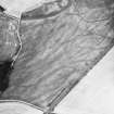
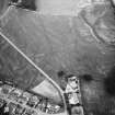
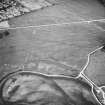
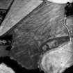
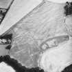
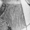
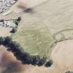
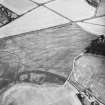
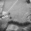
On the NE front of the large fort, a very narrow cropmark appears just outside the fort ditch, from which it diverges slightly before it curves round to the SW to take up a direction at right angles, there disappearing in the much broader mark of the fort ditch. Presumably it is to be interpreted as the small ditch of a temporary work earlier than the forts, perhaps an enclosure in use during the fort-building.
J K St Joseph 1965.
Drought conditions in 1968 revealed the cropmark of a very narrow ditch extending SE from the south angle of the small fort. It curved round to the NE as if to assume a direction at right angles, but vanished in the broader crop-mark of the large fort. This length of 150' lies at a slight angle to the defences of both forts but is parallel to and of the same small size as the ditch observed in 1961. These are the only features on this alignment and would appear to represent a small temporary camp earlier than the forts. The NE-SW dimension is some 585' with only 300' of the transverse dimension so far proved.
J K St Joseph 1969.
Scheduled with NN72SE 1, NN72SE 2 and NN72SE 5 as 'Dalginross, Roman fort, annexe, camp and stone circle 200m S of Penfillan... the buried remains of a complex of Roman military remains, appearing as... cropmarks on oblique aerial photographs... across the arable fields immediately to the southwest of Dalginross and to the east of the Water of Ruchill.'
Information from Historic Scotland, scheduling document dated 23 November 2010.
Aerial Photographic Transcription (18 November 1994)
An aerial transcription was produced from oblique aerial photographs. Information from Historic Environment Scotland (BM) 31 March 2017.
Archaeological Evaluation (May 2006)
NN 774 211 An archaeological evaluation was carried out in May 2006 of a small area of land to the rear of Plot 6 in the Campfield development in Dalginross, Comrie. The site lies within a scheduled ancient monument (Dalginross Roman Forts and Camp SAM No.1612, NN72SE 2). Historic Scotland granted scheduled monument consent to evaluate the site with the objective of establishing precisely what, if any, archaeological features survive within it. The results of the evaluation were intended to inform any subsequent application for consent to undertake landscaping works in this area. Three trenches were excavated, covering a 5.5% sample of the area. The evaluation confirmed the presence of a ditch associated with the Roman fort at the S corner of the site. As predicted, the ditch had been truncated by river erosion. A second cut feature was revealed, aligned E to W. This is believed to be a 20th-century pipe trench.
The results demonstrated that the Roman-period ground surface has been destroyed by river erosion over most of the plot with potential for surviving archaeological features limited to the level area along the SE edge of the plot. Evaluation of a high proportion of this area revealed no archaeological features other than the fort ditch and the potential for currently undetected archaeological features within the plot was considered to be negligible.
Archive and report to be deposited in NMRS.
Sponsor: Mr and Mrs Hustwayte
M Dalland 2006
Publication Account (17 December 2011)
Two linear cropmarks are visible protruding from the fort, and were first observed in the early 1960s by St Joseph from the air (1965: 81). The two could relate to an earlier camp or to elements of the fort and its annexe. They lie 172m apart, with some 53m of the south-west side visible and 106m of the north-east.
R H Jones.

