
Pricing Change
New pricing for orders of material from this site will come into place shortly. Charges for supply of digital images, digitisation on demand, prints and licensing will be altered.
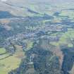
Tom Na Chisaig


Motte (Medieval)
Site Name Tom Na Chisaig
Classification Motte (Medieval)
Alternative Name(s) Feill-ma-chessaig; Callander
Canmore ID 24331
Site Number NN60NW 11
NGR NN 62659 07895
Datum OSGB36 - NGR
Permalink http://canmore.org.uk/site/24331


- Council Stirling
- Parish Callander
- Former Region Central
- Former District Stirling
- Former County Perthshire
NN60NW 11 6266 0789.
(NN 6266 0789) Tom ma Chisaig (NR)
OS 6" map, (1958)
A curious mound, very correctly circular in shape, with a level space at the top 120ft in circumference round the brink. Traditionally erected in memory of St Kessaig.
M Ferguson 1911.
An annual market called Feill-ma-Chessaig was held here in the early 19th century.
NSA 1845.
Flat-topped mote (castle mound) watching the bridge.
OS 6" map annotated by O G S Crawford 15 November 1938.
A regular, flat-topped mound, maximum height 5.0m. Mutilated on the SE by a modern path. Although the mound has the appearance of a motte, it is impossible to be certain without excavation. No additional information.
Resurveyed at 1/2500.
Visited by OS (R D) 9 October 1968.
Field Visit (August 1978)
Tom na Chisaig NN 626 078 NN60NW 11
This conical mound stands 5m high and its level top is 10m in diameter. It is probably a motte.
RCAHMS 1979, visited August 1978
(NSA, x, Perth, 355-6; Stell 1972, 183, no. 190)

