
Tirai


Standing Stone (Prehistoric)
Site Name Tirai
Classification Standing Stone (Prehistoric)
Canmore ID 24172
Site Number NN53NW 19
NGR NN 53085 36700
Datum OSGB36 - NGR
Permalink http://canmore.org.uk/site/24172


- Council Stirling
- Parish Killin
- Former Region Central
- Former District Stirling
- Former County Perthshire
NN53NW 19 5308 3670.
(Area centred : NN 5285 3660) There is a standing stone, damaged by blasting, in the centre of one of the groups of deserted buildings at Tirai (NN53NW 2).
E A Cormack 1952
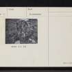
This standing stone, at NN 5308 3670, is situated on a slight plateau in the midst of an old farmstead. It measures c.1.3m high x 1.2m wide and 0.5m thick. It is possibly a survivor of a stone circle as a similar stone is used nearby as a gate-post to an enclosure and several other large stones have been incorporated in the walls of the surrounding buildings.
Stone surveyed at 1/10,000.
Visited by OS (RD) 20 August 1969 and (BS) 8 September 1975
The dimensions of this standing stone are 1.05m high, 1.0m wide and 0.4m thick. It shows evidence of attempts to blast it in a drill hole 0.3m long on the east face. The central area among the features noted on NN53NW 2.31-2.34 is not level. It is stony and in one part there is the suggestion that stone was removed from it.
Though the OS suggest that this standing stone was part of a stone circle involving the stone in the enclosure wall (NN53NW 2.34), and maybe also the very large stone which was used in the construction of NN53NW 2.32, it is difficult to see how this circle must have lain if it were so. That the are was once occupied by a cairn has also been suggested.
A Johnstone and J S Wood 1990; NMRS MS/681, no.70.
Field Visit (September 1978)
Tirai NN 530 367 NN53NW 19
This stone, measuring 1.2m by 0.5m at the base and 1.3m in height, stands in a deserted farmstead. Immediately to the S, an upright stone, which has been used as one side of a doorway, may also have been free-standing originally.
RCAHMS 1979, visited September 1978
Cormack 1950, 171
Field Visit (2012)
Further survey work was carried out on Corrycharmaig (NN 527 358), Duncroisk (NN 530 363), Easter Tullich (NN 526 367) and Tirai (NN 529 367). Of greatest significance over the past year was the discovery, during archival research, of three 17th-century references to a Croftravie or Croftrevie, listed between Innischoarach (NN 493 367) and Corrycharmaig Farms. In 1634–35 Jon and Donald McInnes, the latter a shepherd, lived there, but by 1688, two McGrigors, Jon and Duncan, were in residence. No other references to Croftravie have been found to date.
Intensive fieldwork, carried out on Corrycharmaig from March to May 2012, discovered the presence, in the oak woods bounding the S banks of the River Lochay, of a small cluster of dry stone structures including a house and outbuildings (NN 5122 3661). It is a possibility that these remains are those of Croftravie. The other findings from the survey comprise shieling-type huts, field systems and several dry stone buildings, one of which is extant to 2.9m high (NN 5141 3649).
On Duncroisk, a survey of a small group of shieling huts above the old head dyke was undertaken (NN 5381 3654). An area of improved ground (NN 5359 3756) immediately below an improvement dyke was also surveyed, including several dry stone and turf buildings and the remains of activities from the Breadalbane Hydro-electric Project of the 1950s.
An update on ACFA’s initial survey in Glen Lochay on Tirai and Easter Tullich is underway. Archaeological features that were noted above an improvement dyke in the early 1990s have been drawn and fieldwalking above the old head dyke is nearing completion. Here, a small group of five shieling huts were recorded in October (NN 5297 3734).
Three ACFA Occasional Papers have been published this year: Tomochrocher, Batavaime and Tuerichan, the latter a former farm now subsumed within Corrycharmaig.
Archive: ACFA Occasional Papers are deposited with RCAHMS and the Stirling and Clackmannanshire SMR
Dugald MacInnes, Association of Certificated Field Archaeologists (ACFA)
2012

