
Pricing Change
New pricing for orders of material from this site will come into place shortly. Charges for supply of digital images, digitisation on demand, prints and licensing will be altered.
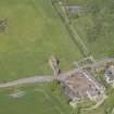
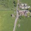
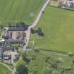
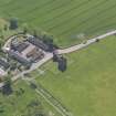
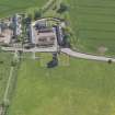
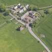
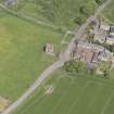
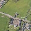
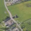
Burleigh Castle, Farmhouse


Farmhouse (19th Century)
Site Name Burleigh Castle, Farmhouse
Classification Farmhouse (19th Century)
Canmore ID 240037
Site Number NO10SW 43
NGR NO 12933 04525
Datum OSGB36 - NGR
Permalink http://canmore.org.uk/site/240037


- Council Perth And Kinross
- Parish Orwell
- Former Region Tayside
- Former District Perth And Kinross
- Former County Kinross-shire
NO10SW 43.00 12933 04525
NO10SW 43.01 NO 12896 04549 1 Farmsteading
NO10SW 43.02 NO 12899 04541 2 Farmsteading
NO10SW 43.03 NO 12903 04533 3 Farmsteading
NO10SW 43.04 NO 12905 04526 4 Farmsteading
NO10SW 43.05 NO 12950 04539 5 Farmsteading
NO10SW 43.06 NO 12945 04550 6 Farmsteading
NO10SW 43.07 NO 12941 04561 7 Farmsteading
NO10SW 43.08 NO 12936 04572 8 Farmsteading
NO10SW 43.09 NO 12919 04560 9 Farmsteading
NO10SW 43.10 NO 12914 04558 10 farmsteading
Field Visit (22 March 2023)
Centred on NO 12923 04542 A range of early 19th century farm steading buildings around a central courtyard. Substantially improved and altered in the late 19th century.
Information from D Bowler - Alder Archaeology Ltd.
OASIS ID: alderarc1-518134

