
Following the launch of trove.scot in February 2025 we are now planning the retiral of some of our webservices. Canmore will be switched off on 24th June 2025. Information about the closure can be found on the HES website: Retiral of HES web services | Historic Environment Scotland
Sron Nan Colan


Lead Mine(S) (Period Unassigned)
Site Name Sron Nan Colan
Classification Lead Mine(S) (Period Unassigned)
Alternative Name(s) Tyndrum Lead Mines
Canmore ID 23895
Site Number NN33SW 2
NGR NN 317 302
NGR Description Centred NN 317 302
Datum OSGB36 - NGR
Permalink http://canmore.org.uk/site/23895


- Council Stirling
- Parish Killin
- Former Region Central
- Former District Stirling
- Former County Perthshire
NN33SW 2 centred 317 302
See also NN22NE 1, NN32NW 1 and NN33SW 9.
(Area centred: NN 317 302) Eight shaft symbols and three roofless buildings shown and described as Lead Mines (NAT). Mineral railway shown from Tyndrum Station (Old Lead Mines on OS 6" 1901).
OS 6" map (1867)
The lead mines at Sron nan Colan were begun in 1741 and together with the mines at Eas Anie (see NN22NE 1) were exploited until 1923. (Full details of ownership and ore-production given).
V A Firsoff 1954
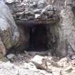
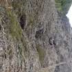
The early mining is represented by foundation remains of two buildings, drystone walling, maximum height 2m, and a long cleft, originally natural, but adapted for working with levels and shafts. About 700m to the NE are extensive remains of the 20th Century workings and track of the old railway.
Visited by OS (FRH) 3 May 1962.
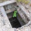
Lead Mine (dis) [NAT]
Shaft (dis) [NAT]
OS 1:10,000 map, 1971.
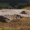
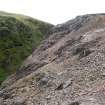
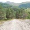
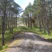
The monument comprises the remains of lead mines and associated activities, located on a NE-facing hillslope to the S of the Crianlarich-Oban railway.
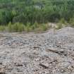
The physical remains survive of lead ore working by open-cast mining, stoping, and deep mining, an inclined railway and a level tramway leading to a crushing plant, and a later ore treatment plant.
Information from Historic Scotland, scheduling document dated August 1993.
Field Visit (2006)
NN 317 302 to NN 316 302
Ore processing areas. On the NW edge of the mine opencast there are a number of areas where lead ore has been worked or dressed by hand. They are characterised by areas of small stone and vein material, generally less than 50mm in size, associated with mortar stones, short retaining walls and the footings of stone huts or cabins. The mortar stones, which were used for crushing ore, have average dimensions of 0.35m x 0.3m x 0.1m deep with circular depression on one or both faces. The mortar stones and hand dressing areas probably relate to an early, possibly 17th-century, period of mining.
NN 3165 3006
Hush dam. Earth and turf dam, 21 x 7m, with rectangular reservoir to SW. Hush channel or gutter runs NE. Possibly a prospecting hush exploring the ground E of the main opencast.
NN 3145 3005 Hush dam. Earth dam, 27 x 3.5m, with stone facing and collecting water in a natural hollow on S flank of Stron nan Colan. Single hush channel runs SSE and then probably splits. Probably a prospecting hush exploring the S course of the Hard and Clay lead veins which here are covered by a thick peat deposit.
NN 3157 3009
Hush dam. Earth and turf dam 10 x 3m, constructed between two rock outcrops; some stone revetment on SE outer face. Hush channel runs SE then E. Probably a prospecting hush.
J Pickin 2006
Publication Account (2009)
The website text produced for Tyndrum webpages on the Forest Heritage Scotland website (www.forestheritagescotland.com).
Introduction: The highs and the lows of Tyndrum mines
Within the hills above the village of Tyndrum, there are the remains of lead mines that have been worked on and off for nearly six hundred years.
The earliest known record of mining in this area was in 1424. Mined, however, for precious metals rather than lead, the mines supplied King James I with silver.
On 30th May 1730, Sir Robert Clifton signed a thirty-eight year lease with the Earl of Breadalbane to mine any metals that he could discover on the earl's estate. In 1740, he discovered lead and established Tyndrum mine the following year. Bad debts, however, led to his imprisonment in 1745 and he gave up his lease.
The Mine Adventurers of England (1746-1760) took over after Clifton's failure. This met with the approval of the Earl of Breadalbane.
"I am sure it will be upon the whole more beneficial and much safer to do with known reputable company than with people who upon trial may be perhaps too late found unequal to the undertaking"
Earl of Breadalbane's estate papers (1746)
Later in the 18th century, the Scots Mining Company (1768-1791) operated the mine and built a smelting works nearby to turn the mined lead ore, called galena, into metal.
Mining for lead, silver and gold continued at various times into the 20th century, but with limited success. Gold mining continues in the area today.
Discover a tale of failure in our People story.
People Story: An expensive ornament!
After the Scots Mining Company shut down at Tyndrum in 1791, a friend of the Earl of Breadalbane wrote
"I suspect there is little chance of Tyndrum ever turning out to profit, even if adventurers can be found to speculate upon it"
Letter written by Mr Campbell of Lochard, dated the 6th of February 1791, quoted by T.C. Smout (1967) in "Lead Mining in Scotland"
Campbell did not know how true his words were. However, many adventurers still tried their luck to mine at Tyndrum over the following decades. They failed, due to the difficulty of mining enough lead to cover the costs of their activities.
One of the strangest examples was in 1838, when the landowner, the 2nd Marquess of Breadalbane, re-opened the mines himself. Over twenty-seven years the mines made a total loss of over £36,500; this would be over 30 million today.
He kept the mines working, despite making a loss, to create jobs for locals. Yet at the same time, he treated staff badly. His German mine managers did not approve of the treatment of the workforce.
"It may look very well on the books, [but] it is only an illusion that a man will work with too low wages"
From letters from S. Rechtendrop and H Odenheimer written in 1847, quoted by T.C. Smout (1967) in "Lead Mining in Scotland"
The German managers believed that he saw the mine as an expensive ornament to show off. He could use it to demonstrate that he was doing something noble for the people who had no jobs on his land.
Check out Corrantee mines and Kirroughtee Lade for more lead mining history.
Field Visit (2013)
NN 3179 3027 (centred on) A survey of was carried out to locate and assess the principal archaeological features at Tyndrum Lead Mine. The mine was worked from 1730–91, reworked in the mid-19th century and reopened 1916–35. Historic mining features survive from all these phases of operation.
The mine worked two mineral veins, Hard Vein and Clay Vein, which outcrop on the NE side of Sron nan Colan. The earliest workings are a series of opencasts and associated hand-dressing floors on the top and central section of the hill between NN 31645 30105 and NN 31923 30379. These probably date from the mid-18th century, although the occurrence of stone ore crushing mortars may indicate an earlier (?16th–17th century) phase of exploitation.
Underground mining appears to have begun with the Scots Mining Company in the 1760s and many of the mine levels in the central section of the hill, including the main haulage level at NN 31923 30379, belong to this phase. These levels were reused and extended in the mid-19th century and again in the early 20th century. At NN 31956 30354 are the foundations of one or more structures on the probable site of the Scots Mining Company’s crushing mill. The Scots Mining Company also explored the mineral veins NE of Tyndrum village and a there is a large hush at NN 32648 31101 to NN 32594 31202.
In the mid-19th century the Marquis of Breadalbane constructed an incline tramway to connect the mine with a new crushing mill at Glengarry. The incline survives as a linear earthwork running downslope from NN 31972 30362 to NN 32295 30517.
In 1916 the Tyndrum Lead and Zinc Company erected a large processing mill at the bottom of the hill (NN 32115 30596) to treat the old mine tips. Features from this period of working include the remains of the large concrete, brick and stone mill building and associated structures, spoil tips, tailings ponds and a tramway embankment. The company also worked underground and drove a haulage and access level, New Level, at NN 31982 30398. Material from this level was taken to the processing mill via a self-acting incline which survives as a linear bank and channel earthwork (NN 31975 30431 to NN 32115 30596).
Archive: Forestry Commission Scotland and RCAHMS
Funder: Forestry Commission Scotland
John Pickin, 2013
(Source: DES)

