
The Hows


Farmstead (Period Unassigned), Rig And Furrow (Medieval) - (Post Medieval)
Site Name The Hows
Classification Farmstead (Period Unassigned), Rig And Furrow (Medieval) - (Post Medieval)
Alternative Name(s) Swanlaws
Canmore ID 238159
Site Number NT71NE 140
NGR NT 77286 16218
Datum OSGB36 - NGR
Permalink http://canmore.org.uk/site/238159


- Council Scottish Borders, The
- Parish Hownam
- Former Region Borders
- Former District Roxburgh
- Former County Roxburghshire
NT71NE 140 7729 1621
Scheduled as 'Swanlaws, farmstead... visible as the footings of several stone buildings.'
[Location transferred from map attached to scheduling document].
Information from Historic Scotland, scheduling document dated 30 January 2003.
Sbc Note
Visibility: This is an upstanding earthwork or monument.
Information from Scottish Borders Council
Field Visit
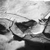
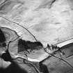
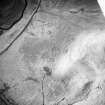
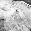
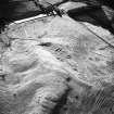
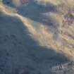
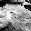
This farmstead, which comprises the stone footings of at least three buildings set in a row, is situated on a W-facing terrace below the steep flank of The Hows. The southernmost building (Kale99 475) of the row measures 15.8m from E to W by 5m transversely within stone walls spread to 2.5m in thickness and about 0.8m in maximum height. The interior is levelled into the slope on the E to a depth of 1m and the floor at the W end is slightly dished; the entrance is on the S. The central building (Kale99 477) measures 10m from E to W by 3.5m transversely within a wall reduced to a stony bank 1m in thickness and up to 0.3m in height. The footings of an earlier building can be seen offset some 1.2m to the S and extending 7.6m to the N. The northernmost building (Kale99 476) measures 10.5m from E to W by 3.8m transversely within stone walls spread to 1.7m in thickness and no more than 0.8m in height. The W end of the building has been slighted by a track and it may have extended a further 3m to the W, the destroyed portion possibly including the entrance. The E end of the building is levelled into the slope, and a bank runs to the S from the SE corner.
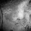
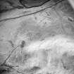
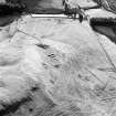
The farmstead is situated within an area of broad curvilinear rig, which extends across the lower slopes on the S, SW and W flanks of The Hows. In all, the rig covers an area of about 20ha in extent and form distinct plots or furlongs; in addition there are several field-banks and an enclosure (NT71NE38).
The rig presents at least two major episodes of cultivation, the earlier defined by deep furrows and the latter by shallow grooves which often appear to subdivide the crowns of the earlier rigs. Most of the rig is aligned across the contour, but on the W-facing slopes the furlongs are aligned along the contour. A plot of narrow straight rig covers an area of about 1ha in extent at the foot of the hill to the W of the modern road.
(Kale99 475-7)
Visible on vertical aerial photograph OS 68/024/083
Visited by RCAHMS (DCC, MFTR) 4 November 1999

