|
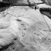
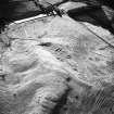
Photographs and Off-line Digital Images |
D 60718 |
RCAHMS Aerial Photography |
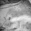
Oblique aerial view centred on the remains of the farmstead and rig, taken from the SSW. |
20/3/2000 |
Item Level |
|
|
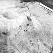
Photographs and Off-line Digital Images |
D 60719 |
RCAHMS Aerial Photography |
Oblique aerial view centred on the remains of the farmstead and rig, taken from the SSE. |
20/3/2000 |
Item Level |
|
|
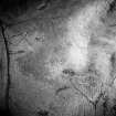
Photographs and Off-line Digital Images |
D 60720 |
RCAHMS Aerial Photography |
Oblique aerial view centred on the remains of the farmstead and rig, taken from the ESE. |
20/3/2000 |
Item Level |
|
|
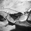
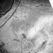
Photographs and Off-line Digital Images |
D 60265 |
RCAHMS Aerial Photography |
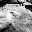
Oblique aerial view centred on the remains of rig with farmstead and rig adjacent, taken from the WSW. |
17/1/2000 |
Item Level |
|
|
Photographs and Off-line Digital Images |
D 60266 |
RCAHMS Aerial Photography |
Oblique aerial view centred on the remains of rig with farmstead and rig adjacent, taken from the SW. |
17/1/2000 |
Item Level |
|
|
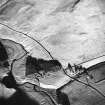
Photographs and Off-line Digital Images |
D 60267 |
RCAHMS Aerial Photography |
Oblique aerial view centred on the remains of farmstead and rig, taken from the NE. |
17/1/2000 |
Item Level |
|
|
Photographs and Off-line Digital Images |
D 60268 |
RCAHMS Aerial Photography |
Oblique aerial view centred on the remains of farmstead and rig, taken from the NNE. |
17/1/2000 |
Item Level |
|
|
Photographs and Off-line Digital Images |
D 60269 |
RCAHMS Aerial Photography |
Oblique aerial view centred on the remains of farmstead and rig, taken from the N. |
17/1/2000 |
Item Level |
|
 |
On-line Digital Images |
SC 1545020 |
RCAHMS Aerial Photography |
Oblique aerial view centred on the remains of farmstead and rig, taken from the NNE. |
17/1/2000 |
Item Level |
|
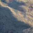 |
On-line Digital Images |
DP 246584 |
Historic Environment Scotland |
Oblique aerial view. |
5/1/2017 |
Item Level |
|
 |
On-line Digital Images |
SC 1748948 |
RCAHMS Aerial Photography |
Oblique aerial view centred on the remains of rig with farmstead and rig adjacent, taken from the WSW. |
17/1/2000 |
Item Level |
|
 |
On-line Digital Images |
SC 1748949 |
RCAHMS Aerial Photography |
Oblique aerial view centred on the remains of rig with farmstead and rig adjacent, taken from the SW. |
17/1/2000 |
Item Level |
|
 |
On-line Digital Images |
SC 1748950 |
RCAHMS Aerial Photography |
Oblique aerial view centred on the remains of farmstead and rig, taken from the NE. |
17/1/2000 |
Item Level |
|
 |
On-line Digital Images |
SC 1748951 |
RCAHMS Aerial Photography |
Oblique aerial view centred on the remains of farmstead and rig, taken from the N. |
17/1/2000 |
Item Level |
|
 |
On-line Digital Images |
SC 1748994 |
RCAHMS Aerial Photography |
Oblique aerial view centred on the remains of the farmstead and rig, taken from the SSW. |
20/3/2000 |
Item Level |
|
 |
On-line Digital Images |
SC 1748995 |
RCAHMS Aerial Photography |
Oblique aerial view centred on the remains of the farmstead and rig, taken from the SSE. |
20/3/2000 |
Item Level |
|
 |
On-line Digital Images |
SC 1748996 |
RCAHMS Aerial Photography |
Oblique aerial view centred on the remains of the farmstead and rig, taken from the ESE. |
20/3/2000 |
Item Level |
|
 |
On-line Digital Images |
SC 1860955 |
RCAHMS Aerial Photography |
Oblique aerial view centred on the remains of farmstead and rig, taken from the NNE. |
17/1/2000 |
Item Level |
|
|
Digital Files (Non-image) |
TM 000541 |
Records of the Royal Commission on the Ancient and Historical Monuments of Scotland (RCAHMS), Edinbu |
Zip file containing all survey linework data recorded during the RCAHMS Afforestable Land Survey of Kale Water 1999 |
1999 |
Item Level |
|


