
Following the launch of trove.scot in February 2025 we are now planning the retiral of some of our webservices. Canmore will be switched off on 24th June 2025. Information about the closure can be found on the HES website: Retiral of HES web services | Historic Environment Scotland
Fort William, Fort And Governor's House


Artillery Fortification (17th Century)
Site Name Fort William, Fort And Governor's House
Classification Artillery Fortification (17th Century)
Alternative Name(s) Cromwell's Fort; Garrison Of Inverlochy
Canmore ID 23715
Site Number NN17SW 1
NGR NN 10415 74323
Datum OSGB36 - NGR
Permalink http://canmore.org.uk/site/23715


- Council Highland
- Parish Kilmallie
- Former Region Highland
- Former District Lochaber
- Former County Inverness-shire
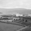
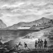
The Fort The garrison of Inverlochy was sited on a triangular piece of land now sandwiched between two roundabouts at the mouth of the River Nevis (diverted early 1970s), just a short distance to the south of the medieval castle of Inverlochy (see p.23 ). Its origin was the small, loosely pentagonal turf and timber fort with wattle ramparts that was thrown up in 1654 by General George Monk to hold about 250 of Cromwell's new model army. After the Restoration this Cromwellian fort fell into disuse and a new fort, named after William III and capable of accommodating 1,000 troops, was raised over the foundations. It commanded an important waterway at the end of the Great Glen, completing the chain that includes Forts George and Augustus. Earthworks were begun in 1690 and the stone structure in c.1698, with 20 ft-high walls, moat, corner turrets and sallyport. It was remodelled by Dugal Campbell, 1746, following a fiveweek Jacobite siege. The fort was garrisoned until 1854 (by this time mainly to discourage smugglers) and eventually largely dismantled in 1864, part being given over to housing and allotments. Engine sheds, goodsyard and the railway line came next, with the purchase of the site by the West Highland Railway Co in 1889. The surviving block of officers' quarters was occupied by railwaymen until 1935, and finally demolished in 1948. Today, only sections of the north and west ramparts of the fort survive on the site, incorporating the sallyport and one demi-bastion.
Taken from "Western Seaboard: An Illustrated Architectural Guide", by Mary Miers, 2008. Published by the Rutland Press http://www.rias.org.uk

NN17SW 1 104 742
(NN 104 742) Fort William (NAT) (Dismantled)
Sally Port (NAT)
OS 6" map (1876)
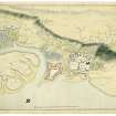
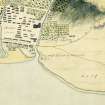
Fort William. The first fort at this site was of turf and wattles thrown up by Monck in the early 1650's and called the garrison of Inverlochy (T Wallace 1911; J B Salmond 1934). A crude plan with features in simple elevation among the Clarke Papers probably represents the same fort consolidated. It lies on the promontory at the confluence of the river Ness and Loch Linnhe. A zigzag trench cuts across the landward side of the fort which was thus surrounded by water on all sides; according to the plan it had one full 3-pointed bastion at the SE corner covering the trench and the bog on the landward side, and demi-bastions at the other four angles of the irregular enciente. The demi-bastions enfiladed one wall only.
The fort was rebuilt in stone in 1690, allegedly on a smaller scale, by General Mackay who renamed it Fort William. It contained a bomb-proof magazine and three block-houses fitted to accommodate 100 men. A fourth block was used as a store. It was defended on the land side by a ditch, glacis and revelin, and on the west side by ramparts faced with stone upon which were mounted fifteen twelve-pounder guns. The fort was entered by a bridge across the ditch; the guard house was immediately inside the fort. Adjoining it were the officers quarters, and in the opposite block of buildings was the general's house. The other buildings were occupied by the men. At the back of the fort towards the River Nevis was the Sally-port.
The fort was dismantled in 1864 and sold. The West Highland Railway Company acquired it in 1889 and a railway yard was built on the site. However stretches of walling have survived the destruction of the entrance and outworks on the landward side of the fort, and about half the rampart perimeter in two long stretches along the shore of the loch and the river survives to a height of about 20' with a demi-bastion at the angle between them.
The masonry indicates two building periods, the first, of river boulders along the loch side, is probably Mackay's work, the second, of superior masonry in roughly squared stones laid in courses and supported by small pinnings, is probably 18th century work. In this is a well-wrought sea-gate in dressed ashlar, round-arched with long and short voussoirs as shown in the plan of 1656.
S Cruden 1960
Fort William, correctly described above. In the wall to either side of the sally port or sea-gate, are regularly spaced gun-loops, one is blocked.
A stretch of walling near the north angle, the east side of a demi-bastion, has been rebuilt, in coursed, roughly-squared masonry with small pinnings, matching the 18th century work. A further adjoining stretch is reconstructed in concrete. This followed undermining due to floods some years ago.
Surveyed at 1:2500.
Visited by OS (ASP) 15 July 1961
No change.
Visited by OS (NKB) 15 May 1970.
Scheduled as Remains of Cromwell's Fort, Fort William.
Information from Historic Scotland, scheduling document dated 21 May 2002.
NN 1046 7430 An archaeological watching brief was undertaken on the excavation of a monument base as part of the Great Glen route, in the area of the fort of Fort William.
No archaeological features or deposits of interest were revealed. Demolition material was recorded from the railway yard that was situated here in the late 19th century.
Full report deposited in Highland SMR and the NMRS.
Sponsor: Highland Council.
S Farrell 2002.
REFERENCE
Fort William At Inverlochie in Lochaber. Inverness-shire.
The National Library of Scotland holds a series of Maps and Drawings (many are coloured) of the Board of Ordnance, relating to the years around the Jacobite Rebellions of 1715 and 1745. Reference "Mss. 1645-1652".
These Drawings include the following in Case, or Volume, No.1645:-
Number. Year.
Z.2/24. No date. "Plan of Fort William and the Country adjacent".
Bears the name of "Robert Johnson, Feeit".
" No date. "Plan of Fort William at Inverlochie in Lochaber"
Scale 100 Feet to 1 and seven-eighth Inch.
" 1709. "Plan of Fort William at Inverlochy in its present
Condition, Augt 1709". About same scale as last.
Z.2/25. 1712. "Plans and Elevation of New Storehouse, built in ye year 1712, Fort William" Scale 10 Feet to about 2 Inches. Bears the name of Lewis Petit.
" No date. "Plans and Elevations, Soldiers' Barracks, Fort William" Scale 10 Feet to about 2 Inches.
Bears name Lewis Petit.
Z.2/26. 1719. "Fort William Anne 1719". Plans and Sections, Officers' Barracks. Scale 10 Feet to an Inch. There is a copy.
" 1719. "Fort William Anne 1719". Plans and Sections of Governor's House, Store House, and Gunner's House. Scale 10 Feet to an Inch.
There are in Case, or Volume, No.1646, the following:-
Z.2/27. 1733 "Profiles--relating to the Plan of Fort William", with Sections and Elevations to Scale of 10 Feet to an Inch. Bears the name of G.Massey.
" 1745. "Plan--of the rebuilding of the Entrance to Fort William, 1745", to scale of 20 Feet to an Inch, and Sections and Elevations to scale of 8 Feet to an Inch. There is a copy made 1769 by J.Delenay, and another made 1812 by John Field.
Z.2/28. 1744. Three Drawings of Fort William dated 1744 and signed Dug Campbell, they are:-
(1) Plan of the Long Pile of Barracks lately repaired, to scale of 16 Feet to an Inch; and details to scale of 12 Feet to an Inch.
(2) Plan Elevation and Sections of the New Pile of Barracks ordered to be built for the Officers at Fort William. Scale 12 Feet to an Inch.
(3) Plan of the Governour's House at Fort William. No scale given.
Z.2/29. 1745. "Plan of Fort William 1745" to scale of 40 Feet to an Inch, with Plan elevation and Sections of the new Barracks, Scale 20 Feet to an Inch, and with Explanation There are 2 copies by John Deleny, 1769.
Z.2/30. 1746 "Plan Elevations and Sections of additional Barracks of Timber, ordered by the Duke of Cumberland to be built at Fort William". Signed by Dug Campbell, 1746. There is a copy.
Z.2/31. 1751. "Plan Elevation and Section of the South Bastion of Fort William shewing the Breach occasioned by the Shooting of Part of the Scarf-wall", 1751. Scale 30 Feet to an Inch. Bears the name T.Walker. There's a copy.
Z.2/31. No date. Small Plans of Fort William, Fort Augustus, and Fort George (Inverness) on the one sheet. Also indexed under Fort Augustus and Fort George (Inverness).
Z.2/32. No date. "A Draught of the long Seljers Barrack already built at Fort William, along Nevish Watter Side". Shews Plan and Elevation. Scale 10 Feet to about an Inch.
" No date. "Barrack at Inverlochy with Officers' Houses".
Scale 10 Feet to an Inch.
There is also, in Case, or Volume, No.1650, this Drawing:-
Z.46/20. 1818. Plan of Fort William and Vicinity. Docketted as "from Sir H.Elphinstone. Date is 1818. This is virtually a map, though a small building, of little interest, is shewn.
----/----
Reference - A panelled room from the Governor's House is now in Fort William Musuem.
Scottish Record Office Reference
Work proceeding on fortifications and houses at Fort William.
Letter to the Earl of Mar from Major General Maitland.
1706 GD124/15/399
Scottish Record Office Reference
[Fort William] Building the Fort.
Account of the expense of building work. It amounts to 10,825 [pounds].
1692 GD 28/2422
Trial Trench (August 2007)
NN 104 742 (fort) In August 2007 a trial trench evaluation (hand-cut trenches) was carried out on the public space known as the Parade in the centre of Fort William. Further trenches were excavated in and outside the remains of the nearby fort which gives its name to the modern town (in Gaelic: An Gearasdan – ‘the Garrison’). The trenches targeted anomalies produced by an earlier geophysical survey.
The aim of the project was to examine the potential for the survival of remains relating to the early history of the
town (Maryburgh) which grew up around the fort which was first constructed in 1654. The town is reported to have been destroyed by the garrison of the fort in March 1746 in order to deprive Jacobite forces of cover when they began a siege of the fort during the later part of the ’45.
A series of trenches in the fort established that very little if anything remains of buried archaeological features related to the life of the fort – at least in the areas investigated. Much of the fort was destroyed following the arrival of the railway in the late 19th century. The portion of the fort surviving was used as a railway yard up until the 1970s and over time engine sheds, inspection pits and a turntable removed any trace of the fort’s interior, which included barrack blocks and other buildings. Midden deposits were encountered heaped up against the exterior of the wall, at the rear of the beach, and there may be potential for earlier midden deposits in other locations outside the fort.
On the Parade, the course of a former burn contained various layers of rich midden material, including ceramics and bottle fragments. Much of this material appears to relate to the 17th and 18th-century occupation of the Parade by buildings which formed the settlement of Maryburgh. Other trenches exposed
quantities of fire-damaged wine bottles of 18th-century type, which along with charcoal-rich deposits and burnt daub provide evidence for the destruction of the town by the garrison in 1746. A series of postholes may relate to the early settlement or later activity.
Archive deposited with RCAHMS, Highland Council.
Funder: Highland Council, Lochaber Community Fund (Highland 2007), Heritage Lottery Fund.
Metal Detector Survey (August 2007)
NN 104 742 The third element of the project was the limited metal detector survey of a ridge known as Tom na hAire, near the old castle of Inverlochy, to the NE of the town. The location is traditionally held to be the site of the victory of a Royalist army led by the Marquis of Montrose over a Covenantor force under the Marquis of Argyll in 1645. Two musket balls were the only finds which could confidently be associated with the battle.
Archive deposited with RCAHMS, Highland Council.
Funder: Highland Council, Lochaber Community Fund.
Note (August 2017)
The story of the fort
Any map of the Great Glen will reveal that there are three ‘Forts’ along its length. The current Fort George replaced a demolished fort of the same name located in Inverness. In the centre of the Great Glen is Fort Augustus, the remains of which have been incorporated into the later abbey, while Fort William is positioned to defend the southern end of the glen. Together they represent successive efforts at governing the Highlands from the mid 17th-19th century.
In 1654, General Monck, the commander of Cromwell’s army in Scotland, began the construction of 'Inverlochy Citadel', as the first fort on the site was called. It was fairly simple, being an irregular pentagon on plan, with defences of earth and turf surmounted by wattle walls. It was situated by the shore of Loch Linnhe at the mouth of the River Lochy and housed 250 men. This fort was one of five erected in Cromwellian times, of which only that at Ayr now survives.
The fort was abandoned in 1660 following the restoration of the monarchy, but was rebuilt in 1690, after years of debate and arguments, when General Mackay was given permission to establish a new fort on the site. With a force of 7000 men, construction was completed 11 days later and Mackay named it 'Fort William' in honour of the King.
The fort comprised a main gate on the south, which was protected by a ravelin and ditch, while contemporary plans suggest that the Sally Port in the north-west was reused. On the south and west, ditches and glacis presented a formable barrier to attack, but the site was overlooked by the steeply rising ground on the south-east. Mackay installed a garrison of 1200 men who were initially housed under canvas. This was not ideal because the weather eventually turned nasty and constant rainfall caused the ramparts to collapse and so timber huts were erected in their stead. A small settlement named 'Maryburgh' (after King William's wife) developed outside the defences. Thereafter, the routine of fort life was largely concerned with policing the surrounding area.
Stone walls were erected in 1698, providing better protection and reducing the time spent on maintenance, while new stone barracks, stores and a magazine were completed by 1714. By then the Jacobite uprisings had begun and the government’s strategy was that the fort and its soldiers would subdue the unruly clans. As part of this plan, General Wade built the two other forts in the Great Glen.
The siege and the aftermath
When Bonnie Prince Charlie landed in 1745, the Fort William garrison watched, safe in the knowledge that the Jacobites did not have the artillery to lay siege. Nevertheless, they prepared for such a possibility, destroying much of Maryburgh in the process to prevent their enemy from using it as a base for attack. On the 20th March 1746, the Jacobites began to lay siege to the fort - the last in the Highlands that still remained in government hand. However, this was resisted and on the 3rd of April the assailants abandoned their positions. Thus ended the last siege on British soil. After the siege Maryburgh needed to be rebuilt and the fort was in need of repair; once the works were complete both town and fort became known as Fort William.
As the Jacobite threat receded, the size of the garrison was reduced and the fort staggered on until 1864, when it was sold by the War Office to Mrs Christina Campbell, who converted the buildings to housing. In 1889 the fort was bought by the West Highland Railway, which demolished a large part adjacent to the old Sally Port for a yard. The officer’s block was used by the railway until 1935, but by 1948 the remaining gable wall had been demolished and with it the last trace of the fort's interior. By the time the railway yard was removed only the northern and western defences remained.
Today, what survives of the fort lies to the north of the town centre, between the railway station car park and Loch Linnhe. This is free to visit, as is a former gate which was reconstructed in 1896 at The Craigs Burial Ground, Belford Road.
Sources:
Miers, M. (2008) The Western Seaboard: an illustrated architectural guide. Edinburgh
Wallace, T. (1911b) Military roads and fortifications in the Highlands, with bridges and milestones', Proc Soc Antiq Scot, vol. 45, 1910-11. Page(s): 330-31
Tabraham, C. and Grove, D. (1995) Fortress Scotland and the Jacobites, B T Batsford for Historic Scotland
Allan Kilpatrick - Data and Recording Projects Officer

