
Glen Aray, Kilmun, Chapel


Burial Ground (Medieval), Chapel (Medieval)
Site Name Glen Aray, Kilmun, Chapel
Classification Burial Ground (Medieval), Chapel (Medieval)
Alternative Name(s) St Mundu's Chapel.
Canmore ID 23426
Site Number NN01SE 1
NGR NN 0793 1306
Datum OSGB36 - NGR
Permalink http://canmore.org.uk/site/23426


- Council Argyll And Bute
- Parish Inveraray
- Former Region Strathclyde
- Former District Argyll And Bute
- Former County Argyll
NN01SE 1 0793 1306.
(NN 0792 1307) Chapel (NR) (In Ruins) Burial Ground (NR)
OS 6" map, Argyllshire, 2nd ed., (1900)
A small ruined chapel, whose walls stood 2' high in 1870, and its burial ground which was still in use for the burial of children and infants in the 18th century, the whole enclosed by a low turf dyke.
The burial ground, oval on plan with a maximum diameter of 43' contains two low mounds, possibly bee-hive cells or graves, which lie to the NE of the chapel.
Bracken prevented a search for grave-markers.
The dedication is to St Mundu or Munnu: Finten (who died in 635), as indicated by the neighbouring farm-name "Kilmun".
New Statistical Account (NSA) 1845; Name Book 1870; W J Watson 1926; M Campbell and M Sandeman 1964.
The chapel measures 6.6m E-W by 3.1m within a turf- covered stone wall 1.2m wide and 0.3m high. The burial ground, c. 20.0m in diameter, is enclosed by a turf- covered stone wall 0.5m high, now spread to a width of 3.0m. At the NE corner of the chapel, there is a small turf-covered mound of stone; its purpose is unknown. The whole site is thickly covered in bracken.
Revised at 1:10,000.
Visited by OS (WDJ) 5 November 1969.
Field Visit (May 1984)
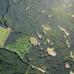
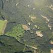
These remains are situated on the W side of Glen Aray, at a height of 175m OD, a short distance S of the rock outcrop of Creag a' Chaibeil ('crag of the burial place') and 350m NNE of Kilmun farmhouse. The adjacent hillside was afforested shortly before the date of visit, but a wide clearing has been left round the site.
The outline of the chapel, which measured 6.6m by 2.7m internally, is represented by turf-covered walls with occasional facing-stones, 1.1m thick and up to 0.3m high. The entrance was towards the W end of the S wall, but the position of its W jamb, and its width, are uncertain.
The chapel lies at the centre of a sub-circular enclosure about 17m in diameter. On the NE, where the adjacent ground is highest, it is cut into the slope, but elsewhere it takes the form of a stony mound about 1.5m thick and up to 0.5m high. Of the various breaks in the enclosure-wall, the most probable entrance is in the SE sector, close to the SE angle of the chapel. There are no identifiable gravemarkers, and a stony mound NE of the chapel appears to be composed of field-clearance material. The chapel and its enclosure resemble others of probable Early Christian date elsewhere in Argyll, and especially in Islay (see Introduction). The dedication was probably to the Irish Saint Finten, or Munnu (d. 635), who visited Iona immediately after the death of Columba in 597. No tradition of recent use for burial was recorded by the Ordnance Survey in 1871 (en 1.).
RCAHMS 1992, visited May 1984
Measured Survey (1984)
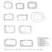
RCAHMS surveyed the chapel and burial-ground, Kilmun, Glen Array in 1984 producing a plan at a scale of 1:100. The plan was redrawn in ink and published at a scale of 1:1000 (RCAHMS 1992, 174A). The plan was also included in an illustration of comparative plans of early chapels published at a scale of 1:250 (RCAHMS 1992, 6E).

