
Scheduled Maintenance
Please be advised that this website will undergo scheduled maintenance on the following dates: •
Tuesday 3rd December 11:00-15:00
During these times, some services may be temporarily unavailable. We apologise for any inconvenience this may cause.
Strachur, Kilmaglash Parish Church And Sculptured Stones


Carved Stone(S) (Medieval), Church (18th Century), Gravestone (17th Century), Gravestone (18th Century), War Memorial(S) (20th Century)
Site Name Strachur, Kilmaglash Parish Church And Sculptured Stones
Classification Carved Stone(S) (Medieval), Church (18th Century), Gravestone (17th Century), Gravestone (18th Century), War Memorial(S) (20th Century)
Alternative Name(s) Strachur And Stachlachlan Parish Church; Strachur Kirk; Kilmolash Church; Strachur Loft; Kilmaglas Church; War Memorials
Canmore ID 23376
Site Number NN00SE 10
NGR NN 09576 01530
Datum OSGB36 - NGR
Permalink http://canmore.org.uk/site/23376


- Council Argyll And Bute
- Parish Strachur
- Former Region Strathclyde
- Former District Argyll And Bute
- Former County Argyll
NN00SE 10.00 09576 01530
(NN 0956 0154) Kilmaglash (NR)
OS 6" map, Argyllshire, 2nd ed., (1900)
NN00SE 10.01 09590 01545 Burial Ground
NN00SE 10.02 09576 01571 Burial Ground Extension
NN00SE 10.03 09548 01581 Burial Ground Extension
For Strachur Cemetery see NN00SE 44
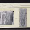
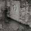
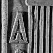
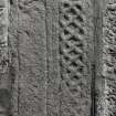
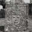
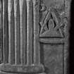
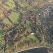
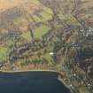
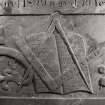
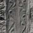
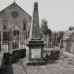
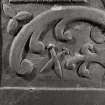
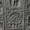
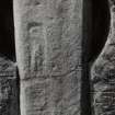
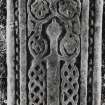
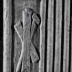
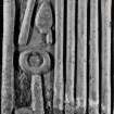
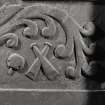
The name of Strachur church is Kilmolash, later corrupted to Kilmoglash. This suggests a dedication to St Molaise. The circular form of the old burial ground is indicative of an early Celtic site, and the fact that the church stands on a mound may mean that there are earlier foundations beneath. The medieval scupltured stones built into the wall of the church, which was built in 1789, came from Chapelverna (NN10SW 1).
M Paterson 1970; G Hay 1957.
Eleven scupltured stones are built into the wall of the church, which is still in use. Other than a small stretch of curvilinear bank to the SE of the church, there is no evidence to suggest an early Celtic site. Unable to verify dedication.
Visited by OS (D W R) 28 February 1973.
INVENTORY OF GRAVEYARD AND CEMETERY SITES IN SCOTLAND REFERENCE:
N.B. This reference applies collectively to NN00SE 10.00, NN00SE 10.01, NN00SE 10.02, NN00SE 10.03 .
Address: Strachur, Kilmaglash Parish Church, Burial Ground and Burial Ground Extensions, Strachur, Cairndow
Postcode: PA27 8DG
Status: In current use for burials
Size: Burial ground: 0.20 hectares, 0.50 acres; Burial ground extension (10.02): 0.08 hectares, 0.20 acres; Burial ground extension (10.03): 0.06 hectares, 0.14 acres
TOIDs:
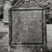
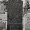
Number of gravestones: 263
Earliest gravestone: 1781
Most recent gravestone: 2002
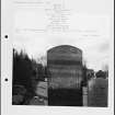
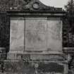
Description: Church with sculptured stones and grave slab; burial ground associated with a church consisting of circular burial ground surrounding church, with burial enclosure and two burial ground extensions adjacent.
Data Sources: OS MasterMap checked 21 September 2005; Graveyard Recording Form dated 17 March 2003
Field Visit (June 1988)
For a full description of the building, and the funerary monuments of medieval and post-reformation date, see RCAHMS 1992 No. 101.
Field Visit (June 1988)
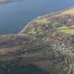
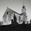
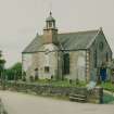
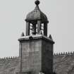
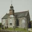
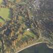
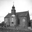
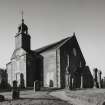
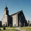
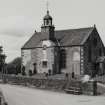
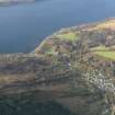
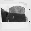
This church is situated 0.7km from the E shore of Loch Fyne, on a slight knoll within an oval churchyard on the N side of Clachan village street (en.1*). It is a rectangular building with a projecting centrepiece on the S front, formerly a porch and now a vestry, which is surmounted by a bird-cage belfry. The masonry is of rubble with advanced quoins and dressings of red sandstone.
As originally built in 1789, the church was hip-roofed with doorways and two storeys of windows in the end-walls, but in an extensive restoration of 1902-3 the gables were raised and each received a central wheel-window above two tall round-headed windows, while the two existing windows in the S wall were altered to the latter form (en.2). The W doorway was blocked, and subsequently the E door was enclosed in a porch. The interior was completely remodelled, with new stained-glass windows and other fittings, and the only early feature is a bow-fronted E gallery with narrow fielded panels, supported on two timber pillars.
The parochial status of Strachur in the medieval period is uncertain, and when first recorded in the 17th century it was part of Lochgoilhead parish. However, Pont's map of about1590 showed an ecclesiastical building at 'Kilmalash', and early 17th-century accounts refer to a church at 'Kilmaglash' or 'Kilmaglais', while a sasine of 1632 mentions the 'chapel of St Malaise’ (en.3). A Latin charter is said to refer to the 'capella Sancti Malaci', and the dedication was evidently to one of the Irish saints named Molaise, probably Laisren or Molaise of Leighlin (Co. Carlow) rather than his namesake of Devenish (Co. Fermanagh) (en.4*).
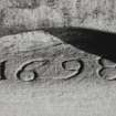
In 1642 it was recorded that the people of the 80 merklands of Strachur had 'builded a church to themselves', which was to be served by the minister of Lochgoilhead, but in 1650 it was separated from the latter and united to Strathlachlan. As defined at that time, the parish extended along the SE shore of Loch Fyne from Strachur to St Catherines, and inland to include the N end of Loch Eck, which was disjoined from Kilmun (en.5). The church was described as ruinous in a petition of 1698 (en.6), and an inscribed lintel (infra, number 1) may indicate repairs at that date, but there is no other evidence of the form of the building. The rebuilding of 1789 did not attract the notice of the local Presbytery, and was presumably carried out in conjunction with General John Campbell, the principal heritor, who is buried in the church (infra, number 20). It was described in 1843 as being 'in need of repair' (en.7), but any work carried out at that time has been obliterated by the repairs of 1902-3, for which the contractor was the local builder Archibald Fergusson.
RCAHMS 1992, visited June 1988
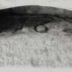
[see RCAHMS 1992 No. 101 for a description of 23 medieval and post-reformation funerary monuments]

