
Pricing Change
New pricing for orders of material from this site will come into place shortly. Charges for supply of digital images, digitisation on demand, prints and licensing will be altered.
Upcoming Maintenance
Please be advised that this website will undergo scheduled maintenance on the following dates:
Thursday, 9 January: 11:00 AM - 3:00 PM
Thursday, 23 January: 11:00 AM - 3:00 PM
Thursday, 30 January: 11:00 AM - 3:00 PM
During these times, some functionality such as image purchasing may be temporarily unavailable. We apologise for any inconvenience this may cause.
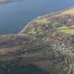
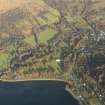
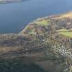
An Dun, Inverglen, Strachur


Dun (Prehistoric)
Site Name An Dun, Inverglen, Strachur
Classification Dun (Prehistoric)
Canmore ID 23375
Site Number NN00SE 1
NGR NN 0973 0182
Datum OSGB36 - NGR
Permalink http://canmore.org.uk/site/23375


- Council Argyll And Bute
- Parish Strachur
- Former Region Strathclyde
- Former District Argyll And Bute
- Former County Argyll
NS00SE 1 0973 0182.
(NN 0974 0185) Fort (NR) (An Dun) (NAT)
OS 6" map, Argyllshire, 2nd ed., (1900)
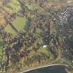
This site, 1/4 mile N of Strachur, consists of two separate structures, (i) a fort, 132' by 63', with a tumbled surrounding wall 6' wide, enclosing (ii) a smaller structure, suggestive of a broch or galleried dun, though without excavation it is impossible to say which. Both faces of its 13' thick walls are well-preserved; it has been much disturbed on the W, but its inner diameter appears to have been c. 36'. A cell, or stair, is traceable in the NE, and an entrance is on the NW.
M Paterson 1970; V G Childe 1932; Information contained in letter from Miss E Rennie to OS, 19 November 1967.
A dun, measuring internally 11.0m in diameter within a wall up to 3.9m wide (between faces) on the E and N. On the S, the rubble wall core is spread to 4.5m in width and no facing stones are visible. Several earthfast stones on the E probably indicate intra-mural structures. A robbing scoop may conceal the entrance the entrance on the W.
To the W is an outwork consisting of a rubble wall up to 3.0m wide, with several inner facing stones remaining on the N, enclosing an area measuring 20.5m E-W by 16.0m N-S. The entrance is probably on the S. There is no evidence to suggest that this enclosure pre-dates the dun.
Surveyed at 1:2500.
Visited by OS (D W R) 28 February 1973.
Field Visit (19 September 1942)
This site was included within the RCAHMS Emergency Survey (1942-3), an unpublished rescue project. Site descriptions, organised by county, vary from short notes to lengthy and full descriptions and are available to view online with contemporary sketches and photographs. The original typescripts, manuscripts, notebooks and photographs can also be consulted in the RCAHMS Search Room.
Information from RCAHMS (GFG) 10 December 2014.
Field Visit (May 1984)
On the summit of a tree-covered knoll 100m SW of Inverglen farmhouse there are the remains of a dun and its outwork. The dun has been severely robbed, presumably to build the field-walls at the base of the knoll, but the outline of the wall, which encloses an area about 12m in diameter, remains clear; several stretches of the outer face may be seen, including a number of massive boulders, and the line of the inner face is reasonably certain, particularly on the N. In general, the S half of the site is less well preserved than the N. The entrance was probably on the W, where there is a large gap in the wall. Several hollows in the rubble core material may indicate the presence of cells, but only one (on the SE) is shown on theplan; there is now no sign of the 'cell' (or stair) noted by Childe in the thickness of the wall on the NE (Childe 1932).
The outwork consists of a wall enclosing an annexe to the W of the dun. The all is very ruinous, but a few facing-stones remain in position; springing from the dun wall near the gap on the W, it probably continued across the gap at the E end of the N side to rejoin the dun wall on the N or NE. The entrance to the annexe is on the S, in line with the top end of track leading up the flank of the knoll.
Visited May 1984
RCAHMS 1988
Measured Survey (11 May 1984)
RCAHMS surveyed An Dun, Inverglen, Strachur dun on 11 May 1984 with plane-table and alidade producing a plan at a scale of 1:100. The plan of the dun was redrawn in ink and published at a scale of 1:250 (RCAHMS 1988a, 171).

