
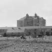
Barbreck House; Offices


Farmstead (18th Century)
Site Name Barbreck House; Offices
Classification Farmstead (18th Century)
Alternative Name(s) Barbreck House; Barbreck House Farm
Canmore ID 233259
Site Number NM80NW 72
NGR NM 83106 06416
Datum OSGB36 - NGR
Permalink http://canmore.org.uk/site/233259


- Council Argyll And Bute
- Parish Craignish
- Former Region Strathclyde
- Former District Argyll And Bute
- Former County Argyll
NM80NW 72 83086 06403.
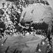
This courtyard farmstead has entrances N and S. The farmhouse and bothy lie side by side to the W. To the N is a stable and two wide arched openings (one much altered) with a loft above. The barn, cart shed and stable are to the E and there is a stable and coach house to the S. There is a separate gabled henhouse to the E. The buildings are of sandstone rubble with slate roofs.
Information from RCAHMS (SS) 12 January 2006.
Field Visit (May 1989)
OFFICES AND OUTBUILDINGS. Arched entrances to the courtyard are located on the NE sides of the pavilions, and the farm offices, rubble-built and single-storeyed with lofts, are grouped around the remaining three sides of the yard. The entire group, including the house, forms a rectangle measuring 50m by 31m over all. The SE range contained a coach-house and connected stables which evidently contained seven stalls. There are, however, no surviving remains of the timber stall-partitions noted in 1961 and a large opening has subsequently been broken through the NE end-wall. Here, as in many parts of the outbuildings, there are traces of the original paved and cobbled floors.
The adjacent unit in the NE range is a byre which connects with a small animal-house. A stable for five cart-horses, a two-bay cart-shed with arched entrances, and a hen-house with stone nesting-boxes make up the remainder of this range. The gutted NW range is known to have been divided into three units, the northernmost having been a laundry with a bothy in the loft above. Pig-sties, and the site of a barn noted in 1961, stand nearby to the NE, and there are dog kennels to the E.
RCAHMS 1992, visited May 1989

