
Dun Mac Sniachan


Dun (Prehistoric), Fort(S) (Prehistoric), Vitrified Stone(S) (Prehistoric), Well (Period Unknown)
Site Name Dun Mac Sniachan
Classification Dun (Prehistoric), Fort(S) (Prehistoric), Vitrified Stone(S) (Prehistoric), Well (Period Unknown)
Alternative Name(s) Dun Mac Uisneachan; Dunmacsniachan; Dun Macuisneachan; Benderloch; Ardmucknish Bay
Canmore ID 23234
Site Number NM93NW 2
NGR NM 90315 38196
Datum OSGB36 - NGR
Permalink http://canmore.org.uk/site/23234


- Council Argyll And Bute
- Parish Ardchattan And Muckairn (Argyll And Bute)
- Former Region Strathclyde
- Former District Argyll And Bute
- Former County Argyll
NM93NW 2 9032 3822.
(NM 9027 3817) Dun Mac Sniachan (NAT) Fort (NR) Dun (NR)
(Undated) OS annotation.
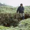
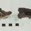
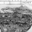
On a steep-sided, isolated ridge lying between the village of Benderloch and the NE shore of Ardmucknish Bay are the remains of a series of defensive works comprising two successive forts and a dun. The earlier of the two forts measures about 245 metres by 50 metres maximum width within a wall which ran round the margin of the summit area of the ridge. This wall survives practically throughout its length as a grass-grown band of stony debris in which five separate masses of vitrified material can be seen. The entrance was probably in the SE through the natural gully in that area. In the scrub-covered interior there are no indications of buildings.
The later fort, situated near the SW end of the ridge, measures 52 by 21 metres within a wholly vitrified wall which overlies the earlier wall on the NW and survives as a grass-covered stony bank spreading to a width of up to 6 metres. On the SE side, a 7 metres stretch of inner facing stones is exposed. The location of the entrance is not now apparent. During excavation in 1873-4 (R A Smith 1872-4) several metal objects (eg a tanged iron sword, an iron dagger, an enamelled bronze circular mount) were found and are now in the NMAS.
The dun is situated at the lower end of the ridge, in the NE, and measures about 18.3 by 15.2 metres within a wall about 3 metres thick. This wall survives as a grass-grown bank of stony debris. The removal of some of the debris on the east side revealed a vitrified mass of core material of the wall of the original fort. On the SW of the dun are the remains of two protecting outer walls running transversely across the ridge at distances of 9 and 18 metres respectively from the wall of the dun. Each of these outer walls has a centrally placed entrance, though no corresponding gap in the actual wall of the dun is visible, and the position it would occupy if in line with the other two is now blocked by four large earthfast stones.
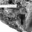
On the SE flank of the ridge, 6 metres outside the wall of the earlier fort, there is a cavity in the rock 1.3 metres square, and normally filled with water fed through a crack in the rock above. This cavity was originally a natural feature but was enlarged and deepened to provide a well.
RCAHMS 1975.
As described. The 'Stone Circle (Remains of)' on OS 6" 1900 Edition, and also shown on Smith's plan was mis-identified. It is, in fact, part of the dun wall.
Visited by OS (DWR) 3 November 1971.
Surveyed at 1:2500.
Measured Survey (8 July 1958)
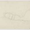
Surveyed with alidade and plane-table at 1mm:1ft on 8 July 1958 during Survey of Marginal Lands. Redrawn in ink and published at the reduced scale of 1:1000 (RCAHMS 1975, fig. 35).
Field Visit (May 1969)
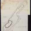
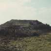
NM 903 382. An important group of remains (to which the spurious name Beregonium. a misreading of Ptolemy's Rerigonium. was mistakenly applied by Hecto rBoece in his Scotorum Historiae), comprising two successive forts and a dun (Fig. 35), is situated on the summit of Dun Mac Sniachan, a steep-sided isolated ridge which stands close to the NE shore of Ardmucknish Bay, overlooking Benderloch Village from a height of 40 m OD. The higher (SW) part of the summit area joins the lower (NE) part at the head of a gully named Bealach na Banrigh, which cuts into the SE flank of the ridge. The gully affords a steep but practicable means of access to the summit, but the easiest approach is up a gentle slope from the NE.
The earlier of the two forts measures about 245 m in length by a maximum of 50 m in breadth internally. Traces of its wall (I) can still be detected almost all the way round the margin of the summit area of the ridge in the form of a grass-grown band of stony debris, in which five separate masses of vitrified material, apparently fused with the underlying rock, are visible as shown on the plan. The entrance was probably at the head of the gully on the SE. The interior is largely covered by scrub and there are no indications of buildings.
The later fort, situated near the SW end of the ridge, measures 52 m by 21 m within a vitrified wall (II) which, on the NW side, overlies the wall of the earlier fort. The remains of wall II appear as a grass-covered stony bank spread to a maximum thickness of 6 m, in which a stretch of inner facing-stones is exposed for a length of 7 m on the SE side. The position of the entrance is not apparent. Excavations carried out by Smith in 1873-4 (PSAS, x (1872-4), 78-80; xi (1874-6), 299-300; xi (1876-8), 14-15, pl. I (plan)), although inconclusive, established that the wall was preserved to a height of nearly 2 m and that its core material was heavily vitrified. Smith also found that at the NE end the wall had been rebuilt, vitrified material from the older structure being incorporated in the new. Some evidence of this reconstruction may be provided by the remains visible at the present time, which show an unexpected salient at the N corner, whereas Smith's plan shows in addition the line of a vitrified wall continuing straight across the base of the salient. Further excavation, however, would be required to establish the nature and extent of the rebuilding. Within the interior Smith found traces of rectangular stone buildings, now no longer visible, and the finds included part of a tanged Iron sword, an Iron dagger, an iron ring, an enamelled bronze circular mount, and a bronze ring, together with several querns and a considerable quantity of animal bones (sheep, pig and cattle). The metal objects are now in the National Museum of Antiquities of Scotland.
The dun, situated at the lower (NE) end of the ridge, measures about 18'3 m by 15'2 m within a wall (IIIA),which now appears as a grass-grown band of stony debris about 3 m in thickness. The removal of some of the debris on the E arc of this wall has revealed a mass of the vitrified core-material of wall I underneath. The dun is protected on the SW by two outer walls (IIIB and IIIC),running transversely across the ridge at distances of about 9 m and 18 m respectively from wall IIIA. The nearer wall (IIIB) appears to have been connected to wall IIIA on the Sand W, but there is no trace of a similar junction between walls IIIB and IIIC. Each of the outer walls has an entrance centrally placed; there is no corresponding gap visible in wall IIIA, and the position it would occupy, if it were situated in line with the other two, is now blocked by four large earthfast boulders.
While it is clear that the larger fort preceded both the smaller fort and the dun, there is at the present time nothing to show whether or not these latter structures were contemporary. The possibility, however, that the dun succeeded the smaller fort is suggested by a comparable group of remains at Dun Skeig (Kintyre) (Inventory of Argyll, I, No. 165), where a threefold sequence has been demonstrated. For further discussion, see pp. 17-18.
WELL. On the steep SE flank of the hill, 6 m outside wall I, there is a cavity in the rock measuring about 1'3 m square and normally filled with water. When cleared out in 1871 (PSAS, ix (1870-2), 85, 396), it was found to be 1'7 m in greatest depth. The cavity was originally a natural feature, subsequently enlarged and deepened to provide a well fed by water percolating through a crack in the rock above.
RCAHMS 1975, visited May 1969.
Note (2 December 2014 - 25 October 2016)
This fort is situated on an elongated ridge that rises from the edge of the shore to the NE of Benderloch Station. Steep slopes and rock faces extend round its flanks, and the easiest access is across the relatively gentle slopes at the NE end. The crest of the ridge is divided into two levels, the upper including the summit at the SW end, and the lower the rest of the spine extending out some 150m to the NE and contracting into a relatively narrow finger no more than 20m wide. The visible fortifications represent at least three phases of construction, the latest of them a relatively small enclosure measuring about 18m by 15m internally, which, along with two walls cutting across the spine of the ridge on its SW, occupies the crest of the narrow finger on the NE. These defences directly overlie the earliest fort, which not only takes in the whole of the narrow finger on the NE, but contours around the flank of the higher end of the ridge on the SW to enclose an irregular area measuring about 250m in length from NE to SW by a maximum of 50m transversely (0.75ha); reduced to a band of grass-grown rubble, RCAHMS investigators noted five separate in situ vitrified masses in its core. No certain entrances have been identified in its near continuous circuit, options being either at the NE end or in a broad gap at the head of a steep gully in the natural re-entrant formed by the topography of the hill on the E. This large fort is also overlain by a small fort occupying the upper, SW, end of the ridge. This appears roughly oval on plan today, but with a dogleg forming a sharp angle where it follows the line of the earlier wall on the NW side. Internally it measures 52m from NE to SW by 21m transversely (0.08ha) and though its heavily vitrified wall is reduced to a bank up to 6m in thickness, there is a run of inner face visible over a distance of 7m on the SE; the position of the entrance is not known. Robert Angus Smith carried out excavations in this small later fort 1873-4, revealing relatively deep deposits within the interior, and in a confused account describing what appear to have been rectangular structures at the NE end and a 'long passage' (Smith 1874; 1876; 1878). Contrary to what is visible today, his plan (1878 pl 1) portrays the line of the wall at the NE end in a regular arc, and he ascribed the dogleg to a later period of reconstruction in which pieces of vitrified stone had been incorporated into the core of a new wall on a different line. In the course of this work they found part of a tanged iron sword, an iron dagger, an iron ring, an enamelled bronze mount, a bronze ring and several quernstones, together with a quantity of animal bones.
Information from An Atlas of Hillforts of Great Britain and Ireland – 25 October 2016. Atlas of Hillforts SC2597

