
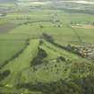
Antonine Wall, Military Way


Frontier Defence (Roman), Roman Road (Roman)
Site Name Antonine Wall, Military Way
Classification Frontier Defence (Roman), Roman Road (Roman)
Canmore ID 231229
Site Number NS57SE 42.05
NGR NS 5565 7239
NGR Description from NS 5500 7192 to NS c.5909 7194
Datum OSGB36 - NGR
Permalink http://canmore.org.uk/site/231229


- Council East Dunbartonshire
- Parish Cadder (Strathkelvin-du)
- Former Region Strathclyde
- Former District Strathkelvin
- Former County Lanarkshire
NS57SE 42.05 from 5500 7192 to c. 5909 7194
NS 5500 7192 to NS 5550 7213 Modern road is on the line of the Military Way (Macdonald 1934).
NS 5500 7192 to NS 5530 7200 Boclair Road is probably on the line of the Military Way.
NS 5565 7239 Excavation by Mr. Graham showed conduits to run not only beneath the Wall, but also under the Military Way (Horsley 1732).
NS 5670 7243 to NS 5700 7257 There is no trace of the Military Way (Horsley 1732).
NS 5782 7213 The Military Way is visible at Summerston (Horsley 1732).
NS 5804 7171 and NS 5820 7166 Details of the Ditch line and Military Way were found during excavations of Balmuidy fort in 1912-14 (see NS57SE 12) (Miller 1922).
NS 5830 7168 to NS c.5909 7194 The Military Way is visible for half a mile E from Balmuidy; two or three chains from the Ditch and parallel with it (Horsley 1732).
Information from OS 1980
Horsley 1732; G Macdonald 1934; S N Miller 1922
In dredging the R. Kelvin N of Balmuildy fort (NS57SE 12) a number of stone blocks were recovered, some with dove-tail cramp-holes. These derived from the stone piers of the bridge carrying the Military Way; other stones together with wooden beams were similarly recovered in 1942.
S S Frere 1983.
Antiquarian Observation (1732)
NS 5565 7239 Excavation by Mr. Graham showed conduits to run not only beneath the Wall, but also under the Military Way (Horsley 1732).
Antiquarian Observation (1732)
NS 5782 7213 The Military Way is visible at Summerston (Horsley 1732).
Antiquarian Observation (1732)
NS 5830 7168 to NS c.5909 7194 The Military Way is visible for half a mile E from Balmuidy; two or three chains from the Ditch and parallel with it (Horsley 1732).
Antiquarian Observation (1732)
NS 5670 7243 to NS 5700 7257 There is no trace of the Military Way (Horsley 1732).
Excavation (1922)
NS 5804 7171 and NS 5820 7166 Details of the Ditch line and Military Way were found during excavations of Balmuidy fort in 1912-14 (see NS57SE 12) (Miller 1922).
Field Visit (1934)
NS 5500 7192 to NS 5550 7213 Modern road is on the line of the Military Way (Macdonald 1934).
Field Visit (1980)
NS 5500 7192 to NS 5530 7200 Boclair Road is probably on the line of the Military Way.
Salvage Record (1982)
In dredging the R. Kelvin N of Balmuildy fort (NS57SE 12) a number of stone blocks were recovered, some with dove-tail cramp-holes. These derived from the stone piers of the bridge carrying the Military Way; other stones together with wooden beams were similarly recovered in 1942.
S S Frere 1983.
Publication Account (1985)
There are two stretches of the stone base of the Wall exposed in the cemetery at New Kilpatlick. Excavated in 1902 and 1922 respectively, they were subsequently consolidated and now offer the best opportunity to view the basal plinth of the Wall. To reach the first section enter the cemetery and continue along the main pathway until the toilets have been passed on the right; the path then divides, take the middle course follow on until it cllIves to the light, the Wall is then in the grass to the right exposed in the bottom of a trench.
The stone base measures about 4.5m in breadth with an inner and outer boulder kerb retaining a rubble core, which is little more than one course deep. An interesting feature visible in this section is the step method of construction. This has been recorded in many places along the Wall and was evidently used on steep slopes, such as this, to provide a more level base for the turf superstructure in order to prevent it from slumping downslope. Also visible in this section is a water culvert which passes through the base of the Wall. These were necessary to allow for the passage of surface water which was otherwise interrupted by the Wall; without them water would have ponded up behind the Wall and eventually led to its collapse.
The second section lies towards the east wall of the cemetery- to reach it, continue up the slope towards the Mausoleum and turn slightly to the right. This portion is similar to the first, except that as it is not built on a slope it is not stepped, and it thus more typical of the Wall as a whole. Although situated on the crest of a knoll, this stretch is also cut by a drainage culvert, suggesting that they must have been built at regulation intervals regardless of whether they were actually required.
Information from ‘Exploring Scotland’s Heritage: The Clyde Estuary and Central Region’, (1985).
Field Visit
NS 5565 7230 I drew two adjacent stretches of the stone base of the Antonine Wall, a total of 47m in length, which had long been exposed in New Kilpatrick Cemetery. John and Anne Macdonald of ACFA undertook surveying in tandem. In both stretches the stone base proved to consist for the most part of water-worn boulders edged by the familiar tapered kerbstones, in local yellow-buff sandstone which has weathered over the decades to grey.
The upper stretch of base, on view since 1921, had a width of 4.3m and was crossed by a single culvert, 0.2–
0.25m wide, which drained water from S to N. Probing at either end of the culvert-passage indicated the presence of basal slabs. Contemporary accounts and early photographs clearly show that capstones were found in situ along the entire length of the culvert; but at present only a single massive capstone sits in place at its southern end, with a smaller domed capstone sitting sideways in the culvert passage behind it.
The lower stretch, uncovered in 1903, has always attracted the greater attention due to the incorporation into it of a ‘step’, in the form of additional large cobbling, evidently intended to counter the sharp southwards slope. The stretch incorporated a single culvert 0.2m wide, long since cleared out, draining water from W to E. The base here was originally 4.3m wide at the northern end and 4.2m wide at the southern end of the stretch, but had been broadened on its eastern side. The western, enemy-facing side remained untouched, with a width of up to 4.6–4.7m. The broadening was in two short strips, to either side of the culvert, which was left untouched. Early photographs show the original east kerb both above and below the culvert. Kerbstones downslope of the culvert are now markedly out of position and some additional larger stones have been set against them, perhaps (quite incorrectly) to fill seeming gaps. The markedly smaller core of the base below the ‘step’ attracts attention as possibly reflecting a change in work-squads or in available materials.
Archive: With excavator pending publication
Funder: Historic Scotland (Culture 2000 Programme)
LJF Keppie (Hunterian Museum and Art Gallery), 2008

