|
Photographs and Off-line Digital Images |
DC 47351/15 |
Records of the Ordnance Survey, Southampton, Hampshire, England |
Ordnance Survey 6-inch to the mile Provisional Edition , Revision of 1933-35 with additions in 1938.
Additional annotations by Ordnance Survey for the Antonine Wall map covering the parishes of Cadder and Bearsden with Balmuildy and Bearsden. |
c. 1938 |
Item Level |
|
|
Photographs and Off-line Digital Images |
DC 47351/16 |
Records of the Ordnance Survey, Southampton, Hampshire, England |
Ordnance Survey 6-inch to the mile Provisional Edition , Revision of 1933-35 with additions in 1938.
Additional annotations by Ordnance Survey for the Antonine Wall map covering the parishes of Baldernock with Crow Hill. |
c. 1938 |
Item Level |
|
 |
On-line Digital Images |
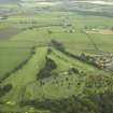
DP 020967 |
RCAHMS Aerial Photography Digital |
General oblique aerial view centred on the course of the Antonine Wall and the military way and the cemetery, taken from the W. |
8/9/2006 |
Item Level |
|
|
Photographs and Off-line Digital Images |
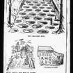
E 72876 S |
Papers of Joseph Harrison Maxwell, archaeologist, Glasgow, Scotland |
The Evening Times - Newscutting, drawings by WA Donnelly. |
14/11/1903 |
Item Level |
|
 |
On-line Digital Images |
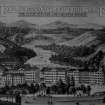
SC 1329432 |
Papers of Joseph Harrison Maxwell, archaeologist, Glasgow, Scotland |
The Evening Times - Newscutting, drawings by WA Donnelly. |
14/11/1903 |
Item Level |
|
 |
Digital Files (Non-image) |
WP 003887 |
Publications by the Royal Commission on the Ancient and Historical Monuments of Scotland |
Exploring Scotland's Heritage: Clyde Estuary And Central Region |
1985 |
Item Level |
|
 |
On-line Digital Images |
SC 1970706 |
Records of Historic Scotland, Edinburgh, Scotland |
Antonine Wall 1:25000 broadsheet map |
2008 |
Item Level |
|
|
Digital Files (Non-image) |
GV 008531 |
Records of Historic Scotland, Edinburgh, Scotland |
Map showing the Antonine Wall, the World Heritage Site area, the areas of the World Heritage Site in public ownership or care, the Buffer Zone and the Council boundaries. Created for the World Heritage Site nomination - Management plan. |
2006 |
Item Level |
|
 |
On-line Digital Images |
SC 2170806 |
Records of Historic Scotland, Edinburgh, Scotland |
Map showing the Antonine Wall, the World Heritage Site area, the areas of the World Heritage Site in public ownership or care, the Buffer Zone and the Council boundaries. Created for the World Heritage Site nomination - Management plan. |
2006 |
Item Level |
|
|
All Other |
551 100/9/2/1 |
Records from the Department of Archaeology, University of Glasgow, Glasgow, Scotland |
Field drawings from excavation at Cadder Military Way, Antonine Wall. |
2001 |
Batch Level |
|
|
All Other |
551 100/9/2/2 |
Records from the Department of Archaeology, University of Glasgow, Glasgow, Scotland |
Inked drawings from an excavation at Cadder Military Way, Antonine Wall. |
2001 |
Batch Level |
|
|
All Other |
551 100/9/2 |
Records from the Department of Archaeology, University of Glasgow, Glasgow, Scotland |
Archive from an excavation at The Cadder Military Way, Antonine Wall |
9/2001 |
Sub-Group Level |
|


