|
Manuscripts |
MS 500/5/4(2) |
Records of the Scottish Industrial Archaeology Survey at the University of Strathclyde, Glasgow, Sco |
5 sheets - map extracts, 1 of which contains location details of mine areas
1 sheet - drawing, Whitesmith mine - plan, south east elevation (20.4.1981)
A 70446-9 B&W prints |
20/4/1981 |
Item Level |
|
|
Photographs and Off-line Digital Images |
A 70446 |
Records of the Scottish Industrial Archaeology Survey at the University of Strathclyde, Glasgow, Sco |
North east elevation of range of buildings - detail of south west end |
20/4/1981 |
Item Level |
|
|
Photographs and Off-line Digital Images |
A 70447 |
Records of the Scottish Industrial Archaeology Survey at the University of Strathclyde, Glasgow, Sco |
Detail of strong room remains |
20/4/1981 |
Item Level |
|
|
Photographs and Off-line Digital Images |
A 70448 |
Records of the Scottish Industrial Archaeology Survey at the University of Strathclyde, Glasgow, Sco |
View from east of site |
20/4/1981 |
Item Level |
|
|
Photographs and Off-line Digital Images |
A 70449 |
Records of the Scottish Industrial Archaeology Survey at the University of Strathclyde, Glasgow, Sco |
View from east of site |
20/4/1981 |
Item Level |
|
 |
On-line Digital Images |
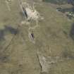
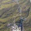
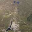
DP 076694 |
RCAHMS Aerial Photography Digital |
Oblique aerial view of the Whitesmith Lead Mines, Strontian, taken from the WNW. |
31/5/2009 |
Item Level |
|
 |
On-line Digital Images |
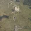
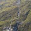
DP 076695 |
RCAHMS Aerial Photography Digital |
Oblique aerial view of the Whitesmith Lead Mines, Strontian, taken from the W. |
31/5/2009 |
Item Level |
|
 |
On-line Digital Images |
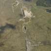
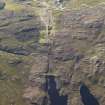
DP 076696 |
RCAHMS Aerial Photography Digital |
Oblique aerial view of the Whitesmith Lead Mines, Strontian, taken from the W. |
31/5/2009 |
Item Level |
|
 |
On-line Digital Images |
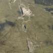
DP 076697 |
RCAHMS Aerial Photography Digital |
Oblique aerial view of the Whitesmith Lead Mines, Strontian, taken from the W. |
31/5/2009 |
Item Level |
|
 |
On-line Digital Images |
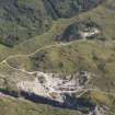
DP 094277 |
RCAHMS Aerial Photography Digital |
Oblique aerial view of the Whitesmith Mine, Strontian, looking W. |
30/8/2010 |
Item Level |
|
 |
On-line Digital Images |
DP 094278 |
RCAHMS Aerial Photography Digital |
Oblique aerial view of the Whitesmith Mine, Strontian, looking WSW. |
30/8/2010 |
Item Level |
|
 |
On-line Digital Images |
DP 094279 |
RCAHMS Aerial Photography Digital |
Oblique aerial view of the Whitesmith Mine, Strontian, looking SSE. |
30/8/2010 |
Item Level |
|
 |
On-line Digital Images |
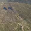
DP 094280 |
RCAHMS Aerial Photography Digital |
General oblique aerial view of the Whitesmith Mine, Strontian, looking ESE. |
30/8/2010 |
Item Level |
|
 |
On-line Digital Images |
DP 094281 |
RCAHMS Aerial Photography Digital |
General oblique aerial view of the Whitesmith Mine, Strontian, looking E. |
30/8/2010 |
Item Level |
|
 |
On-line Digital Images |
DP 094282 |
RCAHMS Aerial Photography Digital |
General oblique aerial view of the Whitesmith Mine, Strontian, looking W. |
30/8/2010 |
Item Level |
|
 |
On-line Digital Images |
SC 2384902 |
Records of the Ordnance Survey, Southampton, Hampshire, England |
Strontian, Whitesmith Mine, NM86NW 3.1, Ordnance Survey index card, Recto |
c. 1958 |
Item Level |
|


