
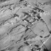
Lismore, St Moluags Cathedral


Burial Ground (Medieval) - (Post Medieval), Cathedral (Medieval), Church (18th Century), War Memorial(S) (20th Century)
Site Name Lismore, St Moluags Cathedral
Classification Burial Ground (Medieval) - (Post Medieval), Cathedral (Medieval), Church (18th Century), War Memorial(S) (20th Century)
Alternative Name(s) Lismore Cathedral; Lismore Church; Kilmoluag Church; Clachan; Lismore Kirk; War Memorial Plaques
Canmore ID 23100
Site Number NM84SE 5
NGR NM 86079 43497
Datum OSGB36 - NGR
Permalink http://canmore.org.uk/site/23100


- Council Argyll And Bute
- Parish Lismore And Appin (Argyll And Bute)
- Former Region Strathclyde
- Former District Argyll And Bute
- Former County Argyll
NM84SE 5 86079 43497
(NM 8609 4350) Church and remains of (NAT)
St Moluag's Cathedral (NR)
OS 1:10,000 map, (1976).
For sanctuary marker at NM 8609 4342, see NM84SE 17.
For cross, see NM84SE 5.01.
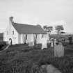
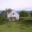
This was the cathedral church of the medieval diocese of Argyll, frequently known as Kilmaluag. The remains consist of an aisle-less choir, now serving as a parish church, the site of a NE chapel or sacristy, and the excavated foundations of an aisle-less nave and added west tower. Although St Moluag founded a religious community on Lismore during the 6th century, there are no remains which can with certainty be ascribed to the early Christian period, and it is likely that the cathedral occupied the site of an earlier church dedicated to St Moluag, an Irish saint (St Lugaidh). However, it is interesting to note that the field boundaries to the north, east and south from a rough circle, of about 240 metres in diameter which may indicate the original line of a vallum similar to those which enclosed certain early monastic sites.
The combined dimensions of the medieval nave and choir were about 38 metres by 7.2 metres within walls which, on average, were about 1 metre thick. The south wall of the choir is divided into three bays by projecting buttresses, each bay containing a round-headed window of 18th century date, while in the cental bay, there is an original round-headed doorway which continued in use until 1900 when restoration work was carried out. The NE and SE angles are also buttressed. The west wall of the choir contains a large, semi-circular headed doorway which served as the main entrance until the restoration work of 1900 during which the belfry which surmounted the west wall was moved to the east gable. At the same time, the two rectangular windows above the doorway in the west wall were replaced by a central, circular window and a new main doorway was formed in the east wall, the outer walls of an old forestair being incorporated into a porch. Excavations in 1970 confirmed the belief that a chapel had existed in the NE of the original building.
Only the western portion of the nave has been excavated, but it had a total length of 20.7 metres and a width identical with that of the choir. There is evidence of buttressing at the north and south corners of the west wall where it joined the nave portion of the building, and the position of a south door to the nave has been identified. The small tower which adjoined the west wall of the nave is of later construction, probably late medieval. Many medieval carved stone slabs are to be seen in the churchyard.
RCAHMS 1975, visited June 1970.
A Brown and A A M Duncan 1915-61.
Field Visit (9 November 1971)
As described. The outline of the cathedral, as located by excavation, is still visible.
Surveyed at 1:2500.
Visited by OS (DWR) 9 November 1971.
Publication Account (1985)
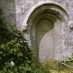
Although now much altered, the parish church of Lismore occupies the choir of the 14th century cathedral of the medieval diocese of Argyll dedicated to St Moluag and is thus one of the earliest churches still used for worship. The cathedral nave to the west barely survives and the tower which was at the west end of the nave is visible only at foundation level. The medieval church was; however, roofless by 1679, and its present state is a result of rebuilding in 1749 at which time the walls were lowered by as much as 3m before it was re-roofed. The external buttresses on the south side are original features, but the round-headed windows appear to date to the 18th century restoration. The interior offers at first sight only the impression of a presbyterian church at the turn of the century, but on the south wall the piscina, sedilia (the seating for the more important clergy) as well as an original doorway still remain visible. The northern doorway is more elaborate with the arch moulding springing from the carved heads of a bishop and a cleric.
Several interesting medieval graveslabs are preserved in the church, and others are in the graveyard.
St Moluag was an Irish saint who founded a Christian community on Lismore traditionally between 561 and 564, and from here he travelled extesively in Pictlandi to him are attributed the foundations, among others, of churches at Rosemarkie, in Ross and Cromarty, and Mortlach, in Banffshire. Thus the present church bears testimony not only to the activities of one of the earliest missionaries to what is now Scotland and to the creation of the diocese of Argyll with its see on Lismore in the late 12th century, but also to the later rebuilding and to the subsequent sensitive restoration of the medieval features by Ian Lindsay in 1956.
Information from ‘Exploring Scotland’s Heritage: Argyll and the Western Isles’, (1985).
Excavation (1994)
Archaeological assessment was commissioned in advance of a proposed extension to an existing cemetery and was conducted by AOC (Scotland) Ltd between 7 and 12 March 1994.
The death of Lugaid or Moluoc/Moluagh, the traditional founder of Lismore and a contemporary of Columba's, is recorded in the Irish Annals for c 592. To date, no material remains of this very early period in the site's history have been recovered or recognised. Lismore was included in the Dioceses of Dunkeld until separated in the late 12th century when the Dioceses of Argyll was created by Innocent III and Lismore was chosen as the episcopal seat and the bishops of Argyll, who were generally styled Episcopi Lismorenses. By the 17th century the Cathedral church was ruinous. In 1749, the choir was adapted to supply the present parish church. The site of these successive medieval and Early Modern buildings may well perpetuate the site of the principal church of the earlier monastic community founded by St Moluagh.
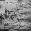
The excavated areas - a total of c 200m sq - comprise five trenches on the N (Trench C), S (Trench A), E (Trench D) and W (Trenches B & E) sides of an existing modern cemetery which lies at the N side of the parish church. The principal features recorded by the assessment are as follows:
Trench A: A series of rubble layers interpretadvely associated with landscaping and demolition on the site in various periods. These are not closely dated.
Trench B: A series of oblong cuts, probably modern machine cuts. A spread of mortar debris, again probably modern or Early Modern. A shallow ditch, near the N end, possibly an early drainage feature.
Trench C: A group of features at the E end, probably representing post-medieval or Early Modern habitation, which included a stone (floor?) spread, midden material and a large post-pit.
Trench D: A single adult inhumation, near the S end, possibly disturbed or re-interred, and probably relatively late in date. Two small pits with charcoal-rich fills.
Trench E: Modern topsoil and rubble dumps.
Sponsor: Argyll & Bute District Council. Acting curator of the site, Strathclyde District Council.
J O'Sullivan 1994.
Field Visit (September 2000)
Masons' marks were recorded by R A Fresson and W A Bartlam, September 2000. These were noted in the interior 'between head and chest height' on the voussoirs of N wall door arch and on the S wall doorway arch and jambs.
NMRS MS/1055
External Reference (2000)
Lismore, St Moluag's Cathedral.
SRO:
Building of the church.
Letter from Archibald Campbell to Colin Campbell of Glenure. He is asked to attend a meeting of the heritors to discuss the project.
1743, GD 170/917/1.
Erected 1749 to serve the adjacent portion of the united parish of Lismore and Appin.
Repair of the church.
Duncan Campbell of Barcaldine is asked by the heritors to obtain estimates for the repair of the church which is in a ruinous condition.
1781, GD 170/1152/2/page 59.
Lismore, St Moluag's Cathedral.
Ross sketch books MS 28/463/13/8.
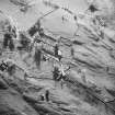
Excavation (12 August 2016 - 19 August 2016)
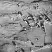
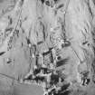
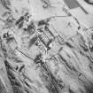
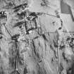
NM 86066 43501 Portions of the stone-built walls of the nave of Argyll’s medieval cathedral on Lismore were exposed in a recent community excavation, 12–19 August 2016, funded by the HLF and with a contribution from Argyll and Bute Council. The cathedral may have been built in the late 12th, 13th or even 14th century and served the newly created diocese of Argyll. Lismore was probably chosen because of its connection with St Moluag, who was a contemporary of St Columba and some argue a more influential missionary than St Columba, as well as its central geographic location and ease of access by sea.
The surviving walls of the nave are substantial, >1m high and of white dressed sandstone, probably imported from Morven, form a drip course near the base. Fragments of white sandstone that would have lined a window have also been discovered within the old graveyard. The stone walls of the nave were bonded using a shell-rich mortar, and samples of charcoal from the mortar will provide a series of radiocarbon dates, finally revealing when the nave was built. Previous excavators in the 1950s discovered a small building built into the W end of the nave and interpreted this as a tower. However, the recent excavation has shown that at least some of the wall has a soil/sod core, and it is clear that this vernacular construction technique is one which would have been very unlikely to be able to support the weight of a tower; it is anticipated that a future investigation will aim to discover the purpose of this building.
The community excavation has allowed the condition of the remains to be assessed. The nave wall and abutting ‘tower’ wall were structurally very stable. However, water penetration of the walls, caused by overlying silty/clay soil and rubble debris has, and is clearly still having, a detrimental effect upon the survival of mortar and the dressed white sandstone drip course. The human (both articulated and disarticulated) and animal bone encountered was found to be in a moderate to good state of preservation.
Public access into the area of the nave was improved with the construction of a wooden gateway that allowed level entry from the modern cemetery. A colour information board was produced and is displayed upon this gate. The site was cleared of debris and a new fence with two gated points of access was also erected around the nave to ensure stock control and avoid unnecessary poaching of the site and
potentially sensitive archaeological deposits.
Archive: NRHE (intended)
Funder: Heritage Lottery Fund, and Argyll and Bute Council
Clare Ellis – Argyll Archaeology
(Source: DES, Volume 17)
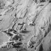
Excavation (15 July 2017 - 22 July 2017)
NM 86066 43501 (NM84SE 5) The second season of this community excavation, 15–22 July 2017, revealed the tower wall has been extensively robbed of stone and the majority of the mortar has dissolved with a gritty soil like substance remaining. However, given the sheer width of the three walls it is felt very likely that the structure was actually a tower, albeit probably not a very high one, which had been added at a later date to the W end of the pre-existing nave. The southern entrance into the nave was re-exposed and recorded; the wall and door just about survive, but the majority of the stone has been robbed. Excavation also demonstrated that
the N nave wall near to the current graveyard wall has been wholly robbed out. However, it was amongst all the small rubble back fill of this trench that a carved sandstone dogtooth moulding that would have adorned perhaps a window or door was recovered and then another was found in an old spoil heap that was being excavated in the hope of just such a find.
Further samples of mortar for radiocarbon dating and analysis were taken from the nave and tower walls. Small samples of sandstone were also taken from the nave for specialist analysis. Further assessment of the condition of preservation of the remains was also made.
Archive: NRHE (intended)
Funder: The Society of Antiquaries of Scotland, The Hunter Trust and The MacDougall McCallum Foundation, USA
Clare Ellis – Argyll Archaeology
(Source: DES, Volume 18)
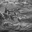
Excavation (30 June 2018 - 14 July 2018)
NM 86079 43497 MacDonald (1974) hypothesised that the vallum monasterii of the early Christian monastery, founded by St Moluag in 562, can still be identified in the current field boundaries around the parish church located in Clachan on Volunteers digging in Trench 3, Lismore Glebe. The aim of this year’s fieldwork, 30 June – 14 July 2018, was to test this hypothesis and to assess the nature of specific features within the boundaries of the glebe. Below the existing dry stone walls a turf bank was identified on the northern side of the boundary surmounted by a pebble path and a limestone cobble surface at two locations on the eastern boundary; unfortunately, no secure dating material was retrieved from either feature type. Significantly, no ditch was found in any of the trenches located over the field boundaries indicating that if the existing boundary of the glebe land follows that of the vallum monasterii then the latter would have had to have been in the form of a bank or wall. The existence of a lower cemetery was also confirmed by the excavations. Although only the upper level of the cemetery was exposed, this revealed that there had been much intercutting of graves and, somewhat surprisingly,
a late phase of metalworking and what appeared to be an in situ cooking hearth, complete with fragments of burnt bone. The lower cemetery was shown to be enclosed by a limestone clay bonded wall which was edged by a stone culvert.
The probable foundation cobbles of an 18th-century track, purported to have been built on the order of the residing minister, so that the populous didn’t have to pass so close to the manse, was also discovered. Adjacent was a probable 18th-century rubble drain and a probable late 19th-century low dry stone wall. A fragment of limestone with a mason’s mark was recovered from within a dump of mostly limestone
rubble.
Archive: NRHE (intended)
Funder: Heritage Lottery Fund
Clare Ellis – Argyll Archaeology
(Source: DES, Volume 19)
Mortar Analysis (2018)
NM 86079 43497 A programme of landscape, buildings and materials analysis is being carried out at Lismore Cathedral within the framework of this project. This has included examination of both main parts of the building, including the W area of the nave and W tower (excavated in a community dig over two seasons), and the standing structure widely recognised as the former cathedral choir. Both of these parts of the building have previously been regarded as multiphase medieval structures. The maintenance of a strip of burial ground between these two multiphase parts of the building has precluded direct assessment of any surviving
stratigraphic relationship between them, however; and the architectural style of the surviving fabric is also typologically broad. As a result, the overall phasing and chronology of the former cathedral is poorly understood.
Buildings analysis suggests the structure of the building is generally consistent with 20th-century descriptions. The stratigraphic relationship between the W tower and nave is clearly displayed in the robbed-out basal plinth socket in the external face of the W nave wall, which is overbuilt by the abutting S and N walls of the tower. Further evidence for this event is presented by incidental (probably secondary) sandstone use in the tower foundation. Any abutment between the choir walls and pultpitum in the upstanding part of the building is currently obscured by internal cladding and external mortar coatings, although some fragmentary evidence for rubble tusking at the SW corner (just above ground level) suggests that these side walls did previously continue westward. All these different parts of the building
have been constructed of lime-bonded rubble. On-site analysis of the surviving and exposed constructional mortars in the building, however, suggests these are predominantly wood-fired calcined oyster shell-lime mortars of remarkably consistent character.
The cathedral has been subject to a continuing programme of materials sampling and lab-based analysis. At the time of writing the sample assemblage contains 39 samples, including: 7 mortar fragments, 7 sandstone fragments, 3 marine shell fragments, and 22 relict fuel inclusions. Lab-based analysis has included thick and/or thin section microscopic analysis of the mortar and sandstone assemblage, shell and fuel assemblage, and radiocarbon analysis of selected fuel samples from the W Nave and W Tower.
The evidence from the analysis suggests the fabric of Lismore Cathedral can be separated into four main suites of masonry evidence, of contrasting character. This includes:
A – The surviving masonry of the choir and nave walls. This is characterised by a formally coursed rubble masonry style, dominated by large basalt face blocks, bound and/or coated with a wood-fired shell-lime mortar, and framed with buff coloured sandstone dressings consistent with an Inninmore source. The relict fuel evidence in the constructional mortar of the W Nave includes a mixture of taxonomies, but is dominated by Quercus.
B – The surviving masonry of the W Tower. This is characterised by an informal rubble masonry style, dominated by limestone slabs, bound with a wood-fired shell-lime mortar, but with no surviving sandstone dressings (except incidental probable secondary use). The relict fuel evidence in the constructional mortar of the W Tower includes a mixture of taxonomies but is dominated by Betula.
C – The surviving masonry of the S nave doorway. This is characterised by at least two different sandstone types, consistent with Lochaline and Carsaig sources in Morvern and Mull, and a more fine-textured mortar with some evidence for altered limestone.
D – The visible masonry of the choir Pulpitum. This is characterised by two different blue-green and very light buff/white sandstones, core rubble dominated by limestone blocks, and a probable wood-fired shell-lime mortar.
The Lismore Cathedral evidence for calcined oyster shell-lime mortars (on an island dominated by limestone geology), changing fuel taxonomies and changing multiple
sandstone sources, is striking, and these four suites of masonry evidence appear to be consistent with at least three and probably four constructional phases. Despite some previously recognised contrasts in moulding details and floor heights, however, this study also draws attention to similarities in the character and form of the nave and choir walls. The evidence for contrasting mortar in the S nave doorway is more fragmentary, and requires further work, but does at least suggest that this feature (with its wider range of sandstones and later mouldings) is likely to be secondary.
Archive: NRHE (intended)
Funder: University of Stirling and Historic Environment Scotland
Mark Thacker – University of Stirling
(Source: DES, Volume 19)
Project
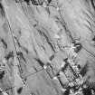
NM 8609 4342 (centre) A geophysical survey was carried out within fields surrounding the parish church at Clachan on the Isle of Lismore as part of a programme of ongoing archaeological evaluation and excavation of an Early Christian monastery and a subsequent later medieval cathedral complex (Canmore ID: 23100). The aim of the geophysical survey was to determine the nature and extent of any buried archaeological remains within the survey area. A gradiometer survey was undertaken over a total area of 3ha with resistance survey covering an area of 0.9ha.
Gradiometer survey of the area to the NW of the church has not detected any anomalies clearly indicating the possible location of the vallum in this area. However, weak trends have been noted which could be archaeologically significant. The gradiometer data from the area to the SE of the church is magnetically noisier. Several discrete areas of increased response have been noted. Their origin is unclear and they may simply be due to modern debris, although an archaeological origin cannot be dismissed. Several weak positive and negative trends have been noted. These are thought to be associated with relatively modern drainage features, although it is possible that they may indicate earlier field divisions. Throughout the area several relatively well-defined discrete positive anomalies have been noted. The origin of these is unclear. However, given that hearths have been revealed by recent excavations, some of these responses may be archaeologically significant.
The resistance survey has recorded a wide variety of responses, although the data is dominated by very strong responses from near surface geology. A trend to the NE of the New Manse is thought to be associated with a wall surrounding an earlier cemetery depicted on early estate plans. However, the cemetery wall revealed during recent excavation has not been clearly defined. A well-defined rectangular area of higher resistance has also been detected in the area. Recent excavations suggest this may indicate archaeologically significant material from the cathedral.
Two well-defined anomalies have been detected just to the S of the well. These comprise a circular anomaly, approximately 6m in diameter, and a rectangular anomaly approximately 5.5m by 4.5m in size. The nature of these responses suggests a possible archaeological origin, although whether they are contemporary and how old they are is not possible to determine from the data.
Archive: Rose Geophysical Consultants
Funder: Argyll Archaeology on behalf of Lismore Historical Society
Dr Susan Ovenden - Rose Geophysical Consultants
(Source: DES Vol 20)
Earth Resistance Survey
NM 8609 4342 (centre) Resistance survey.
Archive: Rose Geophysical Consultants
Funder: Argyll Archaeology on behalf of Lismore Historical Society
Dr Susan Ovenden - Rose Geophysical Consultants
(Source: DES Vol 20)
Magnetometry
NM 8609 4342 (centre) Gradiometer survey.
Archive: Rose Geophysical Consultants
Funder: Argyll Archaeology on behalf of Lismore Historical Society
Dr Susan Ovenden - Rose Geophysical Consultants
(Source: DES Vol 20)

