
Following the launch of trove.scot in February 2025 we are now planning the retiral of some of our webservices. Canmore will be switched off on 24th June 2025. Information about the closure can be found on the HES website: Retiral of HES web services | Historic Environment Scotland
Kipperoch Farm, Civil Starfish


Decoy Site (20th Century)
Site Name Kipperoch Farm, Civil Starfish
Classification Decoy Site (20th Century)
Alternative Name(s) Clyde Aa Defences; Renton
Canmore ID 229120
Site Number NS37NE 168
NGR NS 3667 7782
Datum OSGB36 - NGR
Permalink http://canmore.org.uk/site/229120


- Council West Dunbartonshire
- Parish Cardross (West Dumbartonshire)
- Former Region Strathclyde
- Former District Dumbarton
- Former County Dunbartonshire
NS37NE 168.00 c. 369 782
The remains of a WWII Starfish decoy site (SF 13a) are visible on RAF aerial photographs (58/A/419: 5184-5186) taken on 19 June 1949. The control bunker is situated 800m SE (see NS37NE 168.01).
There is no trace of the decoy site on air photographs taken in 1988 (ASS 51588: 023, 024).
Information from RCAHMS (KM) 3 December 2002.
Field Visit (1 November 2019)
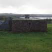
A control shelter (NS37NE 168.01) is all that has been observed of this World War Two Civil Starfish Decoy, which is visible on RAF air photographs (106G/UK.572 2569) flown on 1 August 1945 and (58/A/419: 5184-5186) flown on 19 June 1949. This was one of 18 decoys that were constructed to protect the industries in the centre of Glasgow and along the banks of the River Clyde from aerial attack by the Luftwaffe.
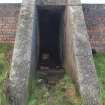
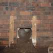
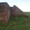
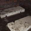
The control shelter (NS 37376 77576), which is situated in improved pasture 19.5m from the crest of a steep scarp overlooking Old Kipperoch and about 160m to its NNE, is cut back into the rising ground and measures 8.75m from NNE to SSW by 4m transversely over brick walls 0.36m thick and 2m high. The flat, reinforced concrete roof has an escape hatch located in the middle of its SSW edge, but only vestiges of the grass-grown earthen blast wall, measuring up to 3.5m thick and only 0.4m high, survive. There is no trace of a brick baffle protecting the canopied entrance, which is centrally placed on the ESE. This leads over a pronounced rectangular concrete threshold into a corridor, which provides access to two compartments at its WNW end. The control room to the SSW measures 3.35m sq. and 2.09m high; and both the walls and the ceiling have been whitewashed. There are no fittings apart from the six steel rungs attached to the SSW wall permitting egress from the escape hatch; but there are two wooden battens attached to the walls close to the SE corner, while another crosses the centre of the ceiling from WSW to ESE. There is an aperture in the roof at the NE corner which was originally provided for the chimney pipe of a stove and there are two rectangular vents just above floor level close to the compartment’s SE and SW corners. The generator room on the opposite side of the corridor is slightly smaller, measuring 3.35m from WNW to ESE by 3.07m transversely and 2.09m high; again, both walls and ceiling have been whitewashed. It contains the plinths for three engines, with the one on the ESE retaining the four upright bolts by which it was fixed, while the others exhibit cut-outs in their flanks for the same purpose. Two rectangular vents are situated close to the SE and SW corners – the latter retaining vertical battens to each side to guide a missing wooden shutter into place. A large circular vent, measuring 0.24m in diameter, situated in the centre of the NNW wall emitted the exhausts from the generators, while three small circular ducts just above floor level conducted gasses to the external expansion chambers of which there is now no trace. The circular vent is only 0.9m above the rising ground on the NNE and this suggests that the N sector of the shelter at least was surrounded originally by a ditch, in which case the expansion chambers would have been placed on its far side.
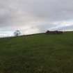
The occupier of Kipperoch Farm reports that the control shelter was robbed of its turf blast wall to enhance the garden of a neighbouring property; and he also believes that the decoy (centred NS 36690 77780) was only fired once. The decoy, itself, was situated in what is now an arable field about 725m WNW of the control shelter. Nothing of it now remains visible, although the earlier farm track by which it was approached still remains in use to this day.
Visited by HES, Survey and Recording (ATW, AMcC, KLG), 1 November 2018
Note (14 January 2021)
The decoy site is visible at NS 3667 7782 on RAF vertical air photograph SCOT_106G_UK_0572_3014 (flown 1 August 1945) lying in an arable field c.725m WNW of the control bunker (see NS37NE 168.01).
The decoy comprises three groups linked by roadways.
The starfish decoy, previously recorded at NS 369 782 was in error and the site NGR changed to match the location on the 1945 aerial photograph.
Information from HES (AKK) 14 January 2021

