
Ederline, Loch Awe


Crannog (Period Unassigned)
Site Name Ederline, Loch Awe
Classification Crannog (Period Unassigned)
Alternative Name(s) Ederline Boathouse Crannog
Canmore ID 22775
Site Number NM80SE 18
NGR NM 8821 0394
Datum OSGB36 - NGR
Permalink http://canmore.org.uk/site/22775


- Council Argyll And Bute
- Parish Kilmichael Glassary
- Former Region Strathclyde
- Former District Argyll And Bute
- Former County Argyll
NM80SE 18 8821 0394.
(NM 8822 0394) Crannog (NR)
OS 1:10,000 map, (1975)
Investigation in 1972 by a naval sub-aqua team under the direction Dr T D McArdle of Edinburgh University confirmed that the island in Loch Awe, about 100 metres NNE of Ederline Boat House, is a crannog. In its construction, a natural bedrock ridge was utilised.
At the time of the investigation, a large amount of timber was seen. A very large quantity of trunks and beams had been exposed in the past when the surface stone was taken away to build up one end of the crannog during a later re-occupation. McArdle noted that one of these trunks had a slot cut into it to aid the builders in fixing an upright timber. He also noted a number of stones set edgeways into the surface.
The crannog was provided with a harbour, consisting of a small bay on the crannog surface next to the spur of bedrock by which it was built, and with a shelving bottom to allow a boat to be drawn up. Three shallow heaps of stones off the south side of the harbour are probably the remains of supports for timber piles.
Part of a saddle quern and part of a rotary quern were found on the crannog and another piece of a rotary quern was found on the nearby shore by the boathouse.
M Campbell and M Sandeman 1964; T D McArdle and C M McArdle 1972.
A small, artificial island protruding very little above water level. No evidence of a causeway was noted.
Surveyed at 1/10,000 scale.
Visited by OS (W D J), 2 March 1970.
NM 8821 0394 A short trial excavation was carried out at Ederline boathouse crannog (NM80SE 18) in Loch Awe in July 2004. A trench measuring 5 x 3m was opened on the NW side of the site and excavated to loch bed level. Underneath the substantial boulder capping layer, well-preserved organic layers were uncovered, consisting of typical crannog deposits such as comminuted plant material, animal droppings, bracken, hazelnuts and twigs. A large amount of charcoal was also recovered, as well as many burnt structural timbers and fragments of burnt bone. Broken structural timbers - one with a mortise joint at one end - were found, along with a substantial bone assemblage comprising all the main domesticates as well as red deer antler, suggesting that the excavated material constitutes refuse or redeposited occupation material. Two sherds of E ware ('a base and body sherd of an E2 beaker') were also recovered, indicating that the excavated material dates from the late 6th or 7th century AD.
Sponsor: Underwater Archaeology Research Centre.
J Henderson and M G Cavers 2004.
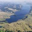
(Location cited as NM 8821 0394). This crannog (which has also been known as Ederline Boathouse crannog) is the most southerly of the dense concentration (comprising at least 20 examples) that are recorded in Loch Awe. This loch occupies a steep-sided rock trough and is the third-largest body of fresh water in Scotland, and also the longest, having a length of 41 miles (66km). It measures up to 94m in depth, the mean being 32m; the level is subject to artificial variation of about 1 or 2m controlled by the Cruachan hydro-electric scheme (NN02NE 12.00).
All the crannogs in Loch Awe can be categorised as of 'stone and timber' type, comprising boulder mounds overlying a substantial timber and organic component. Nine of the 20 surveyed in 1972 displayed visible structural timbers, the Ederline example being that at which the timber component appeared most substantial. This is also the only crannog in Loch Awe to yield chronological evidence, in the form of the radiocarbon determination of 370±45 bc (UB-2415), which may be calibrated to 40-190 cal BC, and is supported by the artifactual evidence of quernstones.
The crannog is visible in summer above water as a low grass-covered stony mound of about 4m diameter. This area represents only a small fraction of the monument. The main mound, which is otherwise submerged, measures 37m by 27m, and is over 2.5m high. It is unusual in being founded on a natural bedrock outcrop, which here takes the form of an elongated reef which runs NE-SW for about 80m in 3 or 4m depth of water. The crannog takes the form of a massive boulder-mound overlying this reef at its SW end, although a large quantity of boulders and several timbers protrude from the silts that fringe the reef along its length. The loch-bed is otherwise flat within the bay, and the locality is little affected by waves raised by the prevailing SW wind.
Prior to the investigations of 2004, numerous structural timbers (massive oak vertical piles and horizontals) protruded from the mound, mostly on the surface and in less than 1m depth of water; the radiocarbon determination was derived from one of these timbers. When surveyed in 1972, the water level was about 2m lower than the average, and about 0.7m lower than in 2004. This allowed inspection of the flat upper surface, the recording of a large number of oak structural timbers, and the identification of two saddle querns and a rotary quern, all of which were left in situ.
Evaluation excavation was carried out in 2004 to investigate the potential survival of organic remains and to contribute towards discussion of the construction and taphonomy of Scottish crannogs. An accurate digital elevation was also created and the surrounding are surveyed bathymetrically using echo-sounding equipment and GPS.
Excavation was carried out underwater, using SCUBA and from a scaffolding platform. A trench (measuring 5x3m) was excavated across the basal edge of the mound, on the NW side, where two large parallel structural timbers protruded at loch-bed level. Following manual boulder of the overlying boulders (context 100), which measured up to 0.8m in diameter, a water-dredge was used for excavation. Beneath the boulders were found smaller stones (context 101), which overlay a layer of white-grey inorganic sands and silts (context 102). Removal of these exposed organic layers comparable to those noted in crannogs at Oakbank and Loch Arthur (NN74SW 16 and NX96NW 1 respectively). These layers were compacted to a thickness of about 40cm, and comprised ecofactual material (including bracken, hazelnuts, twigs and worked pieces of wood, notably wood-chips) in an extremely good state of preservation. These soft deposits were easily excavated using bare hands.
The upper layer of organic material (context 103) measured between 20 and 15cm in thickness, and was found to contain large quantities of charcoal and bone (the latter both burnt and unburnt) in an excellent state of preservation. The many timbers within this context included large structural horizontals, worked points and wood chips. Several timbers were superficially charred, clearly having been close to fire; none of these was demonstrably structural. Groups of burnt timbers and lumps of timber were found together, but these did not form a discrete deposit. Two sherds of E-ware (one of them a portion of base) were found within this context.
Below this context (and clearly separating the two organic deposits) lay context 104, a further inorganic layer which resembled context 102 but contained much the same artifactual and ecofactual material (including bone, charcoal and wood-chips) as context 103. The lower organic layer (context 105) measured 25cm in thickness, was of similar character to context 103, contained similar material, and directly overlay the natural loch-bed.
No piles were excavated, the timbers recorded being all horizontals, predominantly of alder (Alnus sp.). Two large horizontals (timbers 10 and 12) remained in situ, so that their extent could not be established; they were evidently not structural. Timber 9 was broken and also not in situ, resting on the loch-bed at the base of the organic deposits. This was the only major timber that displayed any evidence of structural use, in the form of a circular mortice-hole (measuring about 15cm in diameter); it had broken in antiquity at the opposite end to the mortice. None of the charred timbers was demonstrably structural, and these may be considered to represent dumped fire-waste. If this burning is the result of a conflagration which affected the superstructure of the crannog, these timbers must have been redeposited before being buried beneath further organic deposits and the boulder layer. This point can only be determined by more extensive excavation.
194 bones were recovered from context 103, and represent a rare and important assemblage from a Scottish crannog and Early Historic context. They are presumed to derive from domestic activity on the crannog, being redeposited from a midden deposit. They vary considerably in condition; only 11 could be measured, while 84 were unidentifiable; 61 had been burnt and presumably represent food residue. Cutmarks (from both butchery and skinning) were noted, while three bones had been chewed by dog. The range of species was typical of the period: ox (which was predominant), ovicaprid, pig and red deer. Horse was conspicuously absent. Dairying may have been significant in the local economy, while little primary butchery took place on the site. As might be expected, the joints noted indicate food consumption by people of high status.
The two sherds of E-ware form part of an E2 beaker, a small biconical drinking-cup of Frankish derivation; this type of vessel remains rare but is the second most common form of E-ware found. It was imported into W Britain and Ireland in the late 6th and 7th centuries AD, and so offers a good terminus post quem for the upper organic layer (context 103). Ceramics of this type are found elsewhere in the area, notably at Dunadd fort (NR89SW 1.00), Loch Glashan crannog (NR99SW 1) and Ardifuir dun (NR79NE 2).
A sample from each of two organic layers was analysed to determine the nature of the botanical material in each and the degree of similarity between them. Following wet sieving, microscopic analysis revealed that both deposits contained an abundance of waterlogged wood (mostly fragments, but also roundwood and chips), bracken (both frond and stem fragments) and a monocotyledonous rhizome. This last indicates that turves formed a source of plant material in both contexts; fragments of these were tentatively identified. Pieces of charred herbaceous material and occasional 'sooted' moss-stems suggest the heating of plant material in a protected or compacted state, as in turves. The presence of turf material is confirmed by the achenes of common tormentil (Potentilla cf. erecta), a slow-growing tufted herb found in grass- and heath-land. It is thus likely that much of the plant material is structural and/or fuel-derived. The absence of wood and bracken is consistent with structural debris, while the location and condition of the associated structural debris suggests that this is not in situ. The mosses found include large woodland taxa, which are not typically found on bark but may have been deliberately collected to stop gaps in walls.
Both deposits (particularly the lower) contained crop material in the form of flax seeds and capsule segments, as well as rare small fragments of wheat or rye bran. The lower deposit also contained uncharred rachis fragments of barley and two indeterminate wheat glume-bases. While the rachis could have entered the deposit with cereal straw used for thatching, the absence of straw nodes in both samples suggests that the rachis may represent thatching debris. Other plant remains identified (notably the seeds of rowan, strawberry and bramble, and hazelnut shells) may represent collected wild plant food.
Waterlogged flax seeds were recovered from Early Historic contexts at Buiston crannog (NS44SW 2) and from the earlier crannog at Oakbank (NN74SW 16), which also yielded waterlogged capsule fragments. The discovery of barley rachis at Ederline suggests a contrast to the situation at Buiston, where chaff remains (both waterlogged and charred) were virtually absent, perhaps because crops were brought onto the site already cleaned. Instead, the crop remains at Ederline suggest that both processing and consumption took place at the site, generating both chaff and bran.
The excavation was significant for the provision of accurately-recorded of the submerged deposits, for the discovery of dateable artifacts, and for revealing the nature of the structure and its use. It also demonstrates the complexity of crannog chronology and serves as a warning against over-reliance on individual dates. Exposed organic deposits on crannogs are frequently observed without the need for excavation, but their detailed description is consistently lacking from crannog studies. Only at Oakbank has methodical investigation revealed sealed deposits.
It was hoped that the Ederline trial trench would uncover Iron Age deposits, consistent with the radiocarbon date obtained previously. In the event, the sherds of E-ware recovered from context 103 indicate a terminus post quem between the 6th and 8th centuries AD for the addition of the stone capping, suggesting that the mound remained in use for over 900 years. Here, as elsewhere, the exact nature of the boulder capping remains in doubt. The evidence available at Ederline suggests that the boulders were left as a residue of eroded foundation-deposits. There is no trace of a pile-built structure, but the two large horizontal timbers (10 and 12) may represent fallen palisade-poles similar to those noted at the Loch Glashan crannog. There is no evidence for the deliberate placement of stones at Ederline, where the boulder layer is probably to be seen as comprising both foundation and consolidation.
The deposits contain large quantities of burnt timber, animal bone and pottery, and are indicative of occupation, but are clearly not in situ. They may represent the dumping of refuse over the side, and, on a terrestrial site, would be considered as a midden deposit. The deposits excavated may be seen as representative of occupation levels which have been eroded from the surface of the crannog before becoming waterlogged and overlain by the slumping of foundation boulders as the structure slowly collapsed. The turves found in the deposits may represent the use of turf or peat for fuel, roofing material or structural purposes, while the bracken in these layers may have been deposited after its replacement on the crannog. Further (more extensive) excavation is required to provide a full explanation.
The sequence of occupation observed at Ederline accords with currently observed pattern of occupation of Scottish crannogs. A large number of Iron Age examples (few of them excavated) is known. With occupation spanning the second half of the 1st millennium BC, their assumed status as farmsteads is supported by their association with querns, agricultural implements and areas of better agriculture. The earlier Iron Age date at Ederline is consistent with the increasing use of artificial islets noted in this period. The development of artificial islets with substantial stone superstructures in the mid 1st millennium BC has parallels with the currently envisaged origins of terrestrial Atlantic roundhouses. This is particularly true of Argyll, where there is considerable overlap in physical form between duns and crannogs, bot types being aspects of the same phenomenon. As the Ederline excavation demonstrates, the frequency with which crannogs in Argyll were reused (or continued in occupation) after their Iron Age phases makes it difficult to select specifically Iron Age examples for investigation.
The quality of the Early Assemblage at Loch Glashan (including E-ware, a penannular brooch of the 8th century AD, and a possible book satchel) suggests that this crannog was site of elevated status, with suggestions of literacy and probably a close connection to the royal centre at Dunadd. It may have been a secondary residence of the Dal Riadic kings, in a fashion similar to that suggested in Ireland. Whether Ederline was of similar status remain s unclear, although the character of the faunal assemblage, with its concentration of pre-butchered high value cuts, suggests that this was the case.
(Illustrated with plans, photographs and section: pottery and context descriptions cited, artifacts drawn, and results of faunal and archaeobotanical analyses tabulated).
M G Cavers and J C Henderson 2005.
NM 8821 0394 Underwater excavations were carried out on Ederline Boathouse crannog, in Loch Awe, between 19-25 March 2007 as part of the Scottish Wetland Archaeology Programme. Two trenches were excavated, one at the side of the mound (Trench 1) and one on the top of the mound (Trench 2). The trenches were positioned in an attempt to find in situ occupation deposits on the site and to gain some insight into how the mound was constructed and changed over time. The 3 x 5m trench laid out in 2004 (Trench 1) was extended 2m into the crannog mound. The primary aim of Trench 1 was to uncover the original foundations of the crannog to provide information on how the surviving mound was formed. The rich Early Historic and Iron Age organic levels (Contexts 103 and 105) identified in 2004 were found to run through the entire trench and they are interpreted as discard from the main mound, consisting of moderately compact plant material and red-brown silt containing wood-chips, bracken, hazel nuts, twigs, animal bone and charcoal. Significant amounts of charcoal and burnt bone were recovered from both deposits and several timbers were seen to be superficially charred and had clearly been close to fire before deposition. Disarticulated, broken and worked
structural timbers were found in both contexts throughout the trench. In general, Context 103 produced more bone, charcoal and burnt timber than 105 -this context produced two sherds of E-ware in 2004 and the bottom stone of a schist rotary quern in March 2007. Although the organic deposits became thicker as they approached the main crannog mound, no in situ structural timbers or deposits which could be said to indicate the basal construction levels of the crannog mound were identified.
A trench measuring 7 x 2m (Trench 2) was opened on the surface of the mound in an effort to identify in situ occupation
deposits. Under the stone capping of the mound, horizontal alder timbers laid in layers at roughly right-angles to each other were found throughout the trench sitting within a matrix of grey sandy silt, gravel and small stones. There were no finds from this deposit but it contained small flecks (less than 50mm in diameter) of charcoal and burnt bone throughout, suggesting the deposit been heavily re-worked and mixed over time presumably by water. The layers of horizontal timbers are interpreted as the structural layers of a packwerk mound. Two discrete deposits of comminuted plant material, twigs and bracken were identified in the trench and may represent the fragmentary remains of flooring material. Both were sampled in their entirety for archaeobotanical analysis.
Archive to be deposited with RCAHMS at project end.
Funder: Historic Scotland.
Jon C Henderson, 2007.
Field Visit (April 1985)
In the course of an underwater survey of Loch Awe in 1972 by members of the Naval Air Command Sub-Aqua Club some sixty possible sites were examined and twenty crannogs were confirmed; (Hardy, McArdle and Miles 1973), of these, sixteen are situated in that part of Loch Awe that falls within the Lorn area of Argyll, (RCAHMS 1975), but four at the southern end of the loch are in Mid Argyll. The tops of NM80SE 17 and NM80SE 18 are usually visible above water-level, and the stony causeway of NM80SE 17 may still be seen from the shore.
NM 882 039. About 100m offshore at Ederline boathouse there is a large crannog (37m by 27m and 3m high) built on one end of a submerged spine of rock. (Campbell and Sandeman 1964), Worked timbers were noted in the course of the underwater survey, and a rotary and a saddle quern were found. A sample from a section of wood exhibiting approximately one hundred tree-rings provided a radiocarbon determination of 370bc +/- 45 (UB-2415). (I Morrison 1985)
RCAHMS 1988, visited April 1985.
Excavation (19 March 2007 - 25 March 2007)
NM 8821 0394 Underwater excavations were carried out on Ederline Boathouse crannog, in Loch Awe, between 19-25 March 2007 as part of the Scottish Wetland Archaeology Programme. Two trenches were excavated, one at the side of the mound (Trench 1) and one on the top of the mound (Trench 2). The trenches were positioned in an attempt to find in situ occupation deposits on the site and to gain some insight into how the mound was constructed and changed over time. The 3 x 5m trench laid out in 2004 (Trench 1) was extended 2m into the crannog mound. The primary aim of Trench 1 was to uncover the original foundations of the crannog to provide information on how the surviving mound was formed. The rich Early Historic and Iron Age organic levels (Contexts 103 and 105) identified in 2004 were found to run through the entire trench and they are interpreted as discard from the main mound, consisting of moderately compact plant material and red-brown silt containing wood-chips, bracken, hazel nuts, twigs, animal bone and charcoal. Significant amounts of charcoal and burnt bone were recovered from both deposits and several timbers were seen to be superficially charred and had clearly been close to fire before deposition. Disarticulated, broken and worked
structural timbers were found in both contexts throughout the trench. In general, Context 103 produced more bone, charcoal and burnt timber than 105 -this context produced two sherds of E-ware in 2004 and the bottom stone of a schist rotary quern in March 2007. Although the organic deposits became thicker as they approached the main crannog mound, no in situ structural timbers or deposits which could be said to indicate the basal construction levels of the crannog mound were identified.
A trench measuring 7 x 2m (Trench 2) was opened on the surface of the mound in an effort to identify in situ occupation deposits. Under the stone capping of the mound, horizontal alder timbers laid in layers at roughly right-angles to each other were found throughout the trench sitting within a matrix of grey sandy silt, gravel and small stones. There were no finds from this deposit but it contained small flecks (less than 50mm in diameter) of charcoal and burnt bone throughout, suggesting the deposit been heavily re-worked and mixed over time presumably by water. The layers of horizontal timbers are interpreted as the structural layers of a packwerk mound. Two discrete deposits of comminuted plant material, twigs and bracken were identified in the trench and may represent the fragmentary remains of flooring material. Both were sampled in their entirety for archaeobotanical analysis.
Archive to be deposited with RCAHMS at project end.
Funder: Historic Scotland.

