
Following the launch of trove.scot in February 2025 we are now planning the retiral of some of our webservices. Canmore will be switched off on 24th June 2025. Information about the closure can be found on the HES website: Retiral of HES web services | Historic Environment Scotland
Rousay, South Howe


Broch (Iron Age)(Possible), Ditch (Prehistoric), Settlement (Norse)
Site Name Rousay, South Howe
Classification Broch (Iron Age)(Possible), Ditch (Prehistoric), Settlement (Norse)
Alternative Name(s) Westside; Brough
Canmore ID 2275
Site Number HY33SE 10
NGR HY 3727 3037
Datum OSGB36 - NGR
Permalink http://canmore.org.uk/site/2275


- Council Orkney Islands
- Parish Rousay And Egilsay
- Former Region Orkney Islands Area
- Former District Orkney
- Former County Orkney
HY33SE 10 3727 3037.
(HY 3726 3036) Brough (NR)
OS 6"map, Orkney, 2nd ed.,(1900).
The remains of a probable broch situated on the edge of the low, rocky coastline on the N side of Eynhallow Sound. Some broken fragments of masonry on the shore-side suggest a wall thickness of at least 10 1/2, or possibly 15 ft. Kitchen refuse from the nearby deserted farmhouse is inextricably mixed with the remains. A whalebone weaving-comb, found on the site is now in private possession.
RCAHMS 1946. Visited 1928.
The scant remains of a broch marked by a slight rise. In the shoreline the W arc is visible with traces of the inner and outer faces giving a wall thickness at two places of 3.9 and 4.2 m. The N side of an entrance to a gallery is preserved to a height of 1.7 m, and the gallery to the S of it is visible for a length of some 2.0 m and is 1.2 m wide. Outside the broch to the N are traces of other dry built structures, probably part of a secondary settlement.
Surveyed at 1:2500.
Visited by OS(AA) 10 October 1972.
(HY 3726 3036) Broch (NR) (remains of)
OS 25"map, 1976.
Field Visit (September 1979)
South Howe HY 3727 3036 HY33SE 10
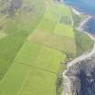
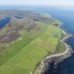
On the low cliff below the ruined farmstead of Brough, this site is visible on the surface as low shapeless hummocks, but in the cliff-section structures extend along a length of nearly 100m, centred on massively heavy stonework which probably represents a broch. This extensive settlement is suffering steady erosion.
RCAHMS 1982, visited September 1979
(RCAHMS 1946, ii, p. 193, No. 552; OR 475)
Publication Account (2002)
HY33 3 SOUTH HOWE ('Westside', 'Broch' or 'Brough')
HY/37273036
Probable broch in Rousay. About 500 m south-east of Midhowe, and also on the coast, are the scanty remains of a stone building in which traces of the inner and outer face of a curved wall, exposed by the sea, are visible on the west arc [1]; these indicate wall thicknesses in two places of 3.9 and 4.2 m. An intra-mural gallery 1.2 m wide is also visible for a length of 2 m; the north side of an entrance to it from the interior can be seen, standing to a height of 1.7 m. [1, 3]. There are traces of outbuildings to the N. Hedges points out that no dimensions were obtained by previous visitors from the exposed section.
A long-handled bone comb of Iron Age type is reported to have been found on the site (and to be in private hands) [2], as has a potsherd, possibly also of the same period [3].
Sources: 1. OS card HY 33 SE 10: 2. RCAHMS 1946, 2, no. 552, 193: 3. Hedges et al. 1987, 117-18: 4. Lamb 1982, 22.
E W MacKie 2002
Excavation (23 June 2010 - 14 July 2010)
HY 3727 3037 (Brough), HY 3723 3036 (Ditch), HY 3753 2966 (Swandro) A team from the University of Bradford, Orkney College (UHI) and City University New York cleaned, recorded and sampled three sites from 23 June–14 July 2010 as part of the ‘Orkney – Gateway to the Atlantic Project’. The project aims to investigate and record coastal sites in Rousay, Egilsay and Wyre which are threatened by rising sea levels and coastal erosion. The Mound of Brough The man-made mound at ‘Brough’,
also known as South Howe, on the SW shore of Rousay contains an eroding Iron Age broch and houses. These structures seem to be overlain by Late Norse buildings which in turn are overlain by 19th-century middens. This broch is only a few hundred metres away from the Broch of Midhowe (HY33SE 2). Coastal erosion has exposed the remains of a settlement mound that is surmounted by the ruins of the farm of Brough.
The active area of erosion extends for at least c70m along the low cliff face. In the centre of the eroding area are the remains of walling which appears to be the outer wall and entrance passage of a broch. This wall survives to a height of 2.5m and varies in width from 4.2m at its base to just under 3m at its highest point. Erosion to the W of this structure appears to be recent, with a cove-like zone extending 2m inland. This zone contained orthostats and flagging. A second zone of active erosion appears c20m to the E. Examination of this area revealed a number of walls; their construction strongly suggests that these remains represent a later phase of settlement, probably dating to the later medieval or early
post-medieval period. The aim of the 2010 season at South Howe was the
characterisation and examination of the potential of the surviving archaeology by tapestry excavation of the cliff exposure. The large expanse of exposed wall core that forms the apex of the visible mound was not cleaned and was left in situ in order to maintain the stability of the wall. Turf and slippage was removed to reveal the outer wall face and the
exposed wall core. To the E of this truncated wall a wall face ran N; this wall face turned at 90° into a second wall that appeared to run W into the mound and form the inner wall of a broch-like roundhouse. The N-oriented face is interpreted as the W side of an entrance passage. The in situ remains of a broken lintel stub projected from this wall. Midden containing 19th-century pottery, probably originating from the farm of Brough at the summit of the mound, appeared to seal the interior of the broch. The broch
seems to have suffered from one or more severe erosion events and this material may represent re-deposition from in situ deposits at the top of the mound. This area was not excavated and requires further investigation to resolve the depositional sequence. The elevations of the eroding cliff sections were photographically recorded, with geo-referenced markers
placed in each frame. This season formed Stage 1 of several years projected work on these exposed remains. The Ditch NE of Midhowe A fluxgate gradiometry survey of the area NE of the guardianship boundary of the Midhowe Broch by staff and students of Orkney College demonstrated
a clear magnetic anomaly running NE for c50m and then turning in a S–SSE direction. The strength of the anomaly was high, although the data suggested that this was a ditchlike feature of anthropogenic origin. An assessment trench, 9.55 x 2.8m, was machine-cut across the anomaly. When excavated, the ditch contained little in the way of cultural evidence, with no artefacts to suggest an infill date. Further geophysical survey after the excavation indicated that the ditch did not continue, but turned to form a small enclosure. The infill sequence suggests material being deposited from the NW. The uniform nature of the stone in the greater part of the ditch corresponds to the type seen in prehistoric clearance cairns. One possibility is that this ditch represents a field division associated with the broch, possibly designed to contain cattle.
Archaeological Evaluation (22 July 2011 - 27 July 2011)
HY 3727 3037 (Brough) and HY 3753 2966 (Swandro) A team from the University of Bradford, Orkney College (UHI) and City University New York cleaned, recorded and sampled the site at Swandro, 22 June–27 July 2011, as part of the ‘Orkney Gateway to the Atlantic Project’. The project aims to investigate and record coastal sites in Rousay, Egilsay and Wyre which are threatened by rising sea levels and coastal erosion.
The Mound of Brough The man-made mound at ‘Brough’, also known as South Howe, on the SW shore of Rousay contains an eroding Iron Age broch and houses. These structures seem to be overlain by Late Norse buildings which in turn are overlain by 19th-century middens. This broch is only a few hundred metres away from the Broch of Midhowe.
The Knowe of Swandro Work on the Knowe of Swandro this year again concentrated on two areas, the mound itself (Area B) and the eroding beach deposits (Area A). An area 4 x 10m was deturfed on the mound and features defined. The structural elements noted in the 2010 season were investigated and appear to be the remains of a substantial double faced curving wall. A small area of paving close to the beach section appears to be later in date.
On the storm beach, the cleared area was extended to 4 x 10m, to assess the extent of the remaining deposits. Midden and other features were found to extend to the high tide mark and further test pitting at low tide revealed that anthropogenic deposits stretched under the storm beach and sand deposits to the low tide line. A sondage in the E corner of the excavated area showed a complex series of stony midden deposits to a depth of >1.5m below the eroded surface; at this depth, a freshwater spring made excavation difficult, but the sondage demonstrates the depth of midden deposits under the eroding beach. Finds from these middens include a worked bone pin, pottery and well preserved bone.
The remains of a prehistoric structure, first investigated last year, were further excavated and samples taken for environmental evidence and radiocarbon dating. A single radiocarbon date indicated a date in the 1st to 2nd century AD. Archaeomagnetic dates obtained from an earlier hearth indicate use in the 4th to 2nd centuries BC.
Clearance of large beach boulders on the W edge of Area A revealed large dressed stones, much battered by the storm beach, forming a substantial wall which could be shown to be the continuation of the large curving wall seen in Area B.
Stratigraphically above the structure excavated last year, and physically further up the beach, a paved area, a fragment of hearth surround and a series of cells formed from orthostats indicated the presence of a later structure. The evidence suggests that Swandro is a multi-period settlement.
This years excavations have demonstrated that the deposits at Swandro are much deeper than initially suspected and the extent of the site much greater. Marine erosion has proceeded in a stepped fashion, so that the earliest deposits survive in greatest extent below the storm beach, whilst the later deposits are fragmentary.
Archive and reports: Orkney SMR and RCAHMS (intended). Digital record: ADS (intended)
Funder: Orkney Islands Council, University of Bradford, Orkney College and City University of New York
University of Bradford/ Orkney College, 2011
Magnetometry (16 April 2018 - 26 April 2018)
HY 37051 30722 (North Howe), HY 37274 30377 (South Howe), HY 37352 29774 (Knowe of Rowiegar), HY 37531 29661 (Knowe of Swandro), HY 37626 29296 (Westness Viking Houses), HY 4398 3224 (Rinyo) and HY 40065 27452 (Burrian)
The RGK undertook a survey campaign on Rousay, 16 – 26 April 2018, as part of the Boyne to Brodgar Project. It aimed to provide a landscape perspective of two Neolithic core areas on the island – Westside and Rinyo. Moreover, the diachronic development in both areas will be researched, concentrating on the processes of formation and degradation of land use over time.
At Westside the survey area stretched from Westness Farm in the S to the rugged area N of North Howe, where the rocky surface and shrubbery prevented further activity (c56ha). The survey focused on the lower fields close to the coast and to the known Neolithic chambered cairns of Knowe of Swandro, Knowe of Rowiegar and Mid Howe. Some fields had to be omitted because the device could not drive across their steep slopes and rocky ground. Several new anthropogenic anomalies and structures can be observed in the imagery. In the SE field of the surveyed area a possible new mound is most striking. A circular structure, 9.5m in diameter, of high magnetic susceptibility was evident about 250m NW of the mound. In the N further settlement structures surrounding North Howe Broch have been revealed. Track-like linear structures follow downhill from the N towards the SW, and E of these, and NW of North Howe several possible settlement structures are evident. Three circular roundhouse structures are located 20m N of the broch, their diameter is between 8.5 and 11m. Immediately W of North Howe a concentration of stone might result from broch related debris, but could also reveal remains of further building activity in this location. Further investigations will hopefully reveal details about the chronology and function of some of the anomaly clusters.
The Neolithic settlement of Rinyo is positioned in a valley between Faraclet Head and Kierfea Hill in the N of Rousay. During the survey, 50.5ha of gradiometer data were captured from fields surrounding Bigland and Houseby Farms in the S of the valley. The NW area of the survey showed traces of ploughing and some field boundaries. Apart from the interior structuring of Rinyo settlement site several new features have been identified in the adjacent fields to the N and S. A circular to oval structure of 20 – 22m in diameter is positioned about 40m NW of Rinyo’s extent. Inside the settlement, internal details can be identified, and the magnetic susceptibility of the structure is relatively high with values up to 18.0 nT. In the field SE of Rinyo, a cluster of several structures is evident. Several circular and semi-circular features with diameters between 12 – 22m, as well as linear anomalies, signify a focus of settlement activity. About 100m SE of the modern Bigland Farm a further nucleus of settlement or burial activity of uncertain date and type was found. A linear structure in the SW of the surveyed area could result from an igneous dyke. Several anthropogenic anomalies can be found around the dyke.
Two fields were surveyed N of Burrian Broch on the S coast of Rousay. Part of the broch has eroded into the sea and the part facing the coast was not accessible with the 3m rig. The N part of the cavity wall and the possible outer boundary ditch are visible in the magnetometry data. The fields contain dipole anomalies, probably resulting from modern metal waste. Some faint traces of rig and furrow-like features can be detected in the areas close to the coast. Several linear features of higher magnetic susceptibility may also be of modern origin (heavily burnt material was visible on the ground surface).
This report highlights some of the larger structures brought to light with the surveys. Many further features, visible of in the imagery, are still undergoing analysis, and more complementary work is needed to further identify their function and chronology, and their meaning in the composite usage of the land.
Gradiometer survey was predominantly conducted with a GPS-supported 14-sensor fluxgate GM650B gradiometer device mounted on a quad-drawn 3m wide rig. At Westside, the fields close to the sea were not accessible with the large rig. These were surveyed with a 2m rig mounted with five sensors with a similar technical configuration to the larger one.
The works were carried out in collaboration with the University of the Highlands and Islands Archaeology Institute, Orkney College, County Archaeologist Julie Gibson, Orkney Islands Council, the National Museum of Scotland and University College Dublin.
All survey results are reported to Historic Environment Scotland and the Rousay Community
Funder: RGK
Ruth Beusing and Knut Rassmann – Römisch-Germanische Kommission, Frankfurt (RGK) of the German Archaeological Institut (Deutsches Archäologisches Institut)
(Source DES Volume 19)

