
Pricing Change
New pricing for orders of material from this site will come into place shortly. Charges for supply of digital images, digitisation on demand, prints and licensing will be altered.
Upcoming Maintenance
Please be advised that this website will undergo scheduled maintenance on the following dates:
Thursday, 30 January: 11:00 AM - 3:00 PM
During these times, some functionality such as image purchasing may be temporarily unavailable. We apologise for any inconvenience this may cause.
Luing, Ballycastle


Dun (Prehistoric), Fort (Prehistoric)(Possible)
Site Name Luing, Ballycastle
Classification Dun (Prehistoric), Fort (Prehistoric)(Possible)
Alternative Name(s) 'North Fort'
Canmore ID 22618
Site Number NM71SE 1
NGR NM 75231 12058
Datum OSGB36 - NGR
Permalink http://canmore.org.uk/site/22618


- Council Argyll And Bute
- Parish Kilbrandon And Kilchattan
- Former Region Strathclyde
- Former District Argyll And Bute
- Former County Argyll
NM71SE 1 7523 1205
(NM 7523 1206) Fort (NR)
OS 1:10,000 map, (1976)
This is a fort and is generally as described. The outwork to the east and south could represent the remains of an earlier fort since (a) its close proximity to the outer face of the fort makes its defence value negligible (b) it is heavily robbed, unlike the wall of the fort and (c) it disappears in the north, the weakest point of the hill, where an outwork contemporary with the fort should be of considerable strength. Surveyed at 1:2500.
Visited by OS (DWR), 17 September 1971.
Measured Survey (3 May 1966)
RCAHMS surveyed this site by plane-table and alidade on 3 May 1966 at a scale of 1mm:1ft. The resultant plan was redrawn in ink and published at 1:1000 (RCAHMS 1975 Fig. 50).
Field Visit (May 1966)
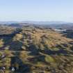
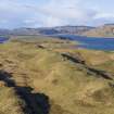
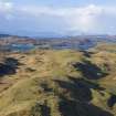
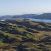
NM 752 120. This dun, also known locally as the 'North Fort', stands on a rocky knoll which forms the highest part of a small ridge (55 m OD) immediately E of Ballycastle farmhouse. The flanks and S end of the ridge are moderately steep, but from the N there is easy access over gently sloping ground.
Oval on plan (Fig. 50, plan), the dun measures 32'0 m by 18'3 m within a wall which varies in thickness from about 4'0 m to 4'7 m on each side of the entrance. Considerable stretches of both the inner and outer faces are visible, but the lowest courses are everywhere hidden by a mass of fallen debris which covers most of the interior and extends down the flanks of the knoll in a scree-like spread. On the SE where it is best preserved, the inner face is exposed for a height of 2 m in ten courses, and the amount of debris suggests that it probably reached a height of at least 3 m originally. The best visible portion of the outer face is on the S, where the fallen stones have been cleared back over a distance of about 8 m to reveal it standing 1'1 m in height in four courses.
The entrance, on the E, is clearly defined. Measuring 1'45 m in width at its outer end, the passage is checked for a door at a point 1'22 m from the outside. Only the N door-check can now be seen as there has been a considerable collapse of the masonry on the S side and the passage itself is now largely filled with debris. Beyond the check the passage increases to a maximum width of 2'13 m at its inner end. Another gap in the wall on the SW appears to be merely a modern breach caused by stone-robbing.
The wasted remains of an outer defensive wall can be seen intermittently on the edge of a narrow terrace on the E and S; all that now survives is a number of massive blocks, some of them still in position and others now lying dislodged nearby, which represent the lowest course of the outer face. Wherever possible natural outcrop has been incorporated in the line of this wall. No trace of the wall can be seen on the N and W, and its function has evidently been to afford a protective screen to the main entrance to the dun.
RCAHMS 1975, visited May 1966.
Note (25 November 2014 - 18 May 2016)
This small fortification is situated on a rocky knoll forming the summit of a ridge. Oval on plan, it measures 32m from NNE to SSW by 18m transversely within a wall from 4m to 4.7m in thickness. Long runs of both the inner and outer faces of the wall are visible, the inner on the SE standing at least 2m in eight courses, and there is sufficient fallen rubble to suggest that its original heigt was in the order of 3m. The outer end of the entrance passage is 1.45m wide, and a check is visible in its N wall some 1.2m from the outside. Concentrically placed on the S and E, but leading off northwards on the NE, there is a heavily-robbed outer wall with massive outer facing-stones, which is conventionally interpreted as an outwork but might easily be the remains of an earlier and larger enclosure.
Information from An Atlas of Hillforts of Great Britain and Ireland – 18 May 2016. Atlas of Hillforts SC2547
Project (2020 - 2021)
Mary Braithwaite – Association of Certificated Field Archaeologists (ACFA) and Luing History Group
NM 7430 1000 (centred on) The walkover survey undertaken since 2017 continued during 2020, focusing on the recording of field and township boundaries and further investigation of several sites. These included a promontory earthwork at Blackmill Bay (NM 7339 0838); a substantial 18m diameter turf-and- stone structure at Park (NM 7419 1169); an 18th-century croft at Ballachuan (NM 7483 1348); and evidence of a roundhouse settlement with possible coaxial field system E and S of Ballycastle fort at Ardinamar (Canmore ID: 22618). A LiDAR survey flight of the island was undertaken on September 9 2020.
In March 2021 field walking of land being dug for woodland planting at Cuan turned up several flints including an arrowhead blank (NM 7513 1398). In June 2021 the survey team spent a week completing the recording of features on the neighbouring island of Torsa, including late 19th-century boat graffiti (Canmore ID: 304894), and on Luing recording two crofts, one at Achafolla (NM 7454 1016) the other west of Park (NM 7380 1124), and investigating previously-unidentified internal features at Dùn Ablaich earthwork (Canmore ID: 22554).
Funder: Luing History Group and Association of Certificated Field Archaeologists
Note (14 September 2022)
NM71SE 1 75231 12058
This massively constructed dun dominates the NE part of Luing and has extensive views across the island and eastwards towards Loch Melfort and is generally as described by RCAHMS. Though no excavation has been documented, the entrance passage has been cleared (the rubble is set immediately outside and overlies the outer wall) while sections of the wall face have evidently been exposed by pulling rubble back to establish their line, a practice that was common in the late 19th century. This helped RCAHMS produce a plan that shows both the inner and outer faces of the dun. They also recorded a denuded outer wall which may be an outwork, as they suggested, or the remains of a larger and earlier fort.
Information from HES Archaeological Survey (GF Geddes), 14 September 2022.

