
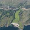
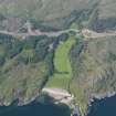
Rubh' Aird Ghamhsgail, Arisaig


Dun (Period Unassigned), Fort (Period Unassigned)
Site Name Rubh' Aird Ghamhsgail, Arisaig
Classification Dun (Period Unassigned), Fort (Period Unassigned)
Alternative Name(s) Rubh' Ard Ghaunsgail
Canmore ID 22529
Site Number NM68SE 2
NGR NM 6929 8400
Datum OSGB36 - NGR
Permalink http://canmore.org.uk/site/22529


- Council Highland
- Parish Arisaig And Moidart
- Former Region Highland
- Former District Lochaber
- Former County Inverness-shire
NM68SE 2 6929 8400.
(NM 6929 8400) Vitrified Fort (NR) (Remains of)
OS 6"map, Inverness-shire, 2nd ed., (1902)
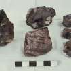
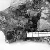
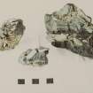
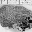
Arisaig Fort is also knows as Arka Unskel, Ard Ghaunsgoik and Ard Ghamhgail. It is divided into two by a natural depression, the part to the landward being about 50 feet in either direction within a heavily vitrified wall, the outer part only about 24 feet (Feachem 1963).
The vitrified walls are traceable all round the circumference but are most perceptible at A B C and D. They vary from 3-7 feet in height and from 5-6 feet in thickness (Hamilton 1880). The gap on the E. may have formed the entrance to both forts (Cotton 1954).
R W Feachem 1963; E Hamilton 1880; M A Cotton 1954.
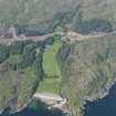
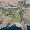
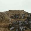
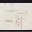
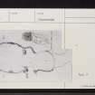
On the summit of a rocky promontory named Rudh' Ard Ghamhsgail are the remains of a dun, sub-circular on plan, and measuring c 12.5m in diameter within a turf-covered wall about 3.30m - 4.0m thick, showing masses of vitrifaction. The NE arc is destroyed and no entrance is apparent. With the exception of a line of stones in the N.possibly an outer wall face, there is no trace of built masonry. To the N of the
dun at a lower level are traces of a turf-covered wall in which no vitrifaction can be seen. With the cliffs to the E, it encloses an area approximately 14.0m N-S by 9.0m E-W which is bisected by a stony scarp running E-W. No entrance is visible.
This may constitute an outwork but it is more likely to be part of an earlier fort whose S end is overlaid by the dun. The whole complex is surrounded by cliffs and steep rocky slopes, which are less severe in the NW, the only logical means of access.
Along the W base of the promontory is a gully, whose W side is a ridge of outcrop rock. Gaps in this ridge have been blocked by crude walling, traces of which also cross the gulley from W to E at two points. Within the southerly of the two enclosures thus formed is a depression c 4.0m in diameter end 1.0m deep, which may have been a cistern. None of the names quoted by Feachem are known locally.
Surveyed at 1/2500
Visited by OS (NKB) 26 May 1970.
Note (21 November 2014 - 25 November 2016)
The heavily vitrified dun on the summit of this rocky promontory possibly occupies the site of an earlier promontory fort. The dun measures about 12.5m in diameter within a wall reduced to a thick band of rubble with large masses of vitrified core. Some 14m to the N, set on the leading edge of a terrace below the level of the summit, there are also traces of a wall blocking the easiest line of access from the NW. While this may be an outwork to the dun, it betrays no sign of vitrifaction and is possibly the remains of an earlier promontory fort. If so, its interior may have measured at least 35m from N to S by between 9m and 18m transversely (0.04ha), though the greater part at the S end is now occupied by the dun. The position of the entrance is not known and the only feature visible within the interior is a stony scarp cutting across from E to W. Other fragments of crude walling were identified by the OS blocking gaps in a ridge of outcrop to the W and crossing the gully that separates this ridge from the W side of the of the promontory; they also identified a possible cistern, but the relationship of the dun and possible fort to any of these features is not known.
Information from An Atlas of Hillforts of Great Britain and Ireland – 25 November 2016. Atlas of Hillforts SC2539

